Sunday, 25 September 2022

River Ryburn at Sowerby Bridge October 2013

 This small set of pictures was taken along the River Ryburn from Watson Mill Lane to its conclusion flowing into the River Calder just after the railway viaduct at Sowerby Bridge.

The River Ryburn starts in the hills above Baitings Reservoir and flows down the valley approx. 7 miles to its meeting with the River Calder, passing through or near Rishworth, Ripponden, Kebroys and Triangle. Along is route it is fed into by 12 tributaries and passes underneath 13 bridges.

These pictures were taken using a Samsung Galaxy Tablet in October 2013. They can be seen below and on Clickasnap where they are full size, resolution and un-watermarked.

Geese and ducks in the River at Victoria Bridge

The Ryburn flowing in to the River Calder from underneath Sowerby Bridge railway viaduct, the former bridges bar can be seen on the right, as of September 2022 this is being demolished having stood empty for a number of years.


Thanks for looking and please take a moment to share and follow me on social media.

All the pictures remain the copyright of Colin Green.

Saturday, 24 September 2022

Baitings Reservoir Now Very Low 24 September 2022

Baitings Dam is a reservoir built to supply Wakefield with fresh water, completed in 1956 it is the higher of the 2 dams that block the flow of the River Ryburn here, the lower being Ryburn Dam. Construction cost around £1.4 million and took 8 years to complete, it involved flooding a small hamlet known as Baitings and sub merging the old packhorse bridge that provided a road link between Lancashire and Yorkshire, the bridge still stands and is revealed every time the water level is low. The bridge was replaced by a concrete structure called Back O'th Heights Bridge which gives a good indication of how high the dame is when full by the time marks just underneath the road level. When full the dam can hold over 113,000,000 cubic feet of water, or approx. 703,858,407 gallons.

Baitings is fed by runs offs from the local moorland and is the start of the River Ryburn that flows down the valley eventually reaching the River Calder at Sowerby Bridge approx 6 miles down the valley. It also flows in to the Ryburn Dam a little lower down the valley and built in 1933, also to supply water to Wakefield.

The dam must be somewhere near a historically low level now, the bridge completely uncovered and recently a sluice gate has appeared. I am assuming this was to regulate the flow in to the Ryburn Dam prior to Baitings being built. There was a footpath bridge between this sluice gate and the dam head but the water hasn't got low enough yet to reveal wether this is still there. Maybe a couple more weeks of low rainfall and it might appear if still there.

These pictures were taken on the 24th September 2022 using a Nikon d330 SLR camera, they can be seen below and on Clickasnap full size, resolution and un-watermarked.


The packhorse bridge appearing from beneath the water has gone from a once in decade or so event to every couple of years.

Whilst it's likely that levels have been low enough before for the original dam and sluice gate to appear, this was the first time I had seen them.


The original packhorse bridge, often submerged seen through the legs of it's modern replacement.


Thanks for looking and please take a moment to share and follow me on social media.

Clicking any image will open a link in another window to the version on Clickasnap.

All the images remain the copyright of Colin Green.

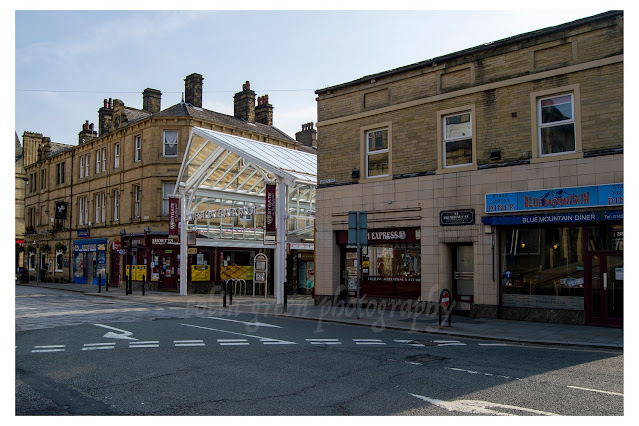
Westgate Arcade, Halifax

 Westgate is one of the oldest streets in the centre of Halifax, originally built to provide access to the nearby Piece Hall on land owned by the vicarage of Halifax, it required an Act of Parliament to enable construction. The road provided access from Southgate to Market Street and then on towards the western gate of the Piece Hall. The area around Westgate was little used and under developed when a number of properties were acquired around the late 1990's and a plan was announced to develop the area in to a covered pedestrian zone including carrier street which connects the arcade with the nearby Borough Market. In 2006 this plan was completed and the mix of independent shops, leisure, bars that occupy the arcade have become a welcome addition to the Halifax scene.

These pictures were taken on the 27th May 2018 using a Nikon d3300 SLR camera. They can be seen below or on Clickasnap full size, resolution and un-watermarked by clicking any image, link opens in another window.


Thanks for looking and please take a moment to share and follow me on social media.

All the pictures remain the copyright of Colin Green.

Monday, 19 September 2022

Stocks Lane Horse Trough October 2013.

 The stone trough at the bottom of Stocks Lane, Luddenden was overgrown and largely forgotten about when I pictured it in October 2013. Trough's were spread around many villages, towns and cities before the coming of the motor vehicle to help water horses, dogs and even in some places cattle. Most have long since been removed or closed off no longer needed, but some can still be seen and a around a dozen still remain the Calderdale district.

The trough at the bottom of Stocks Lane is no longer fed with a large amount of water and most of the trough has been filled in with soil, bushes and plants. At the back is an inscription to William Patchett a local carpenter and undertaker, with the year 1861 and surveyor inscribed too. This was the year Patchett died, i don't know if the inscription is a memorial to him or a thanks to him for providing the trough.

These pictures were taken on the 13th October 2013 using a Samsung Galaxy Tablet. They can be seen below or on Clickasnap full size, resolution and un-watermarked.


Clicking any image should open a link in another window to the version on Clickasnap.

Thanks for looking and please take a moment to share and follow me on social media.

All the pictures remain the copyright of Colin Green.

Sunday, 18 September 2022

Our Lady of the Sacred Heart, Lealholm.

 Our Lady of the Sacred Heart is a Catholic church serving the rural community of Lealholm, North Yorkshire. The foundation stone was laid by Bishop Shine in September 1931 after the local Catholic community raised sufficient funding to build a modest church for worship. The Church opened in 1932.

These 3 pictures were taken on the 27th August 2022 using a Nikon d3300 SLR camera. They can be seen below or on Clickasnap where they are full size, resolution and un-watermarked.


Clicking any image should open a link in another window to the version on Clickasnap.

Thanks for looking and please take a moment to share and follow me on social media.

All the pictures remain the copyright of Colin Green.

Saturday, 17 September 2022

Berry Lane Coal Drops, Halifax

 Added to the Victorian Society's top 10 at risk buildings in 2021 the Berry Lane Coal drops have stood overgrown, abandoned and largely forgotten about for several decades. Despite this the drops are thought to be just a few minor repairs from being fully operational again, even though that is unlikely with the phasing out of coal in most industries.

Built in in 1874 by the Ovenden and Halifax Junction Railway, there are a total of 15 drops built into the embankment used to support the former Halifax Station goods yard. Largely unused since the 1970's, they were granted Grade II listed status on the 28th September 1993. You could still approach quite close to the bottom of the structures until the early 2000's when a piece of masonry fell and the council then fenced off the bottom. Plans to convert the drops in to houses was announced in 2004 but never went much further than the proposals.

These pictures were taken on the 22nd June 2014 using a Polaroid is2132 Bridge Camera. There are a total of 8 to view below and on Clickasnap where they are full size, resolution and un-watermarked.


The spire of Square Church can be seen beyond the drops.

I've always liked how the spire of Square Church, and Halifax Parish Church tower bookend this picture of the drops.


These 2 were taken on top od the drops, I accessed it thru some overgrowth in the Eureka car park.

Clicking any image should open a link in another window to the Clickasnap version of the image.

Thanks for looking and please take a moment to share and follow me on social media.

All the pictures remain the copyright of Colin Green.

Sunday, 11 September 2022

Artworks of Calderdale

 The following are a collection of digital artworks I created based on photograph's I took in 2013 of various well known places of interest in Calderdale. They can also be seen on Clickasnap, where copies can also be purchased or just view if you require.

Todmorden Town Hall.

Hebden Bridge Railway Station

Stoodley Pike Monument

Halifax Railway Station

St Mary's Church Clocktower, Luddenden.

Todmorden Unitarian Church

Ruins of the Church of Thomas a' Becket, Heptonstall

Copley Toll House

Brighouse Library and Smith Art Gallery

Piece Hall before refurbishment

Old Bridge Over Hebden Water, Hebden Bridge

All these pictures can also be seen full size, resolution and un-watermarked on Clickasnap.

Thanks for looking and please take a moment to share and follow me on social media.

All the pictures remain the copyright of Colin Green.

Through a Glass, Darkly: Hebden Bridge Railway Station in Negative

 There's something hauntingly beautiful about old photographs, especially when they're presented in a way that flips our perception....