Showing posts with label Calder. Show all posts

Sunday, 6 February 2022

Copley Toll Booth and Bridge, October 2013 Before the Floods that Destroyed It.

A small set of pictures taken with a Samsung Galaxy Tablet 27th October 2013, they were taken from the now demolished Copley Toll Bridge.

Copley Toll Booth

Copley Toll Booth is now a private residence that stands to the south of present day Wilson Bridge, but in 2013 stood at the end of the s arch stone Copley River (Toll) bridge. The booth was built circa 1831 when the bridge was constructed. This picture can be seen on my Clickasnap Profile un-watermarked, full size and resolution.

Fee structure for crossing the bridge.

The above fee board could be found on the side of Copley Toll Booth when I visited in 2013, I am not sure if the board is still there.


This picture taken stood towards the end of Copley River (Toll) Bridge shows the Toll Booth to the right, and to the left is the lych-gate to St Stephens Church, Copley. North Dean Woods can be seen beyond and the road heads in the direction of Norland and Greetland.


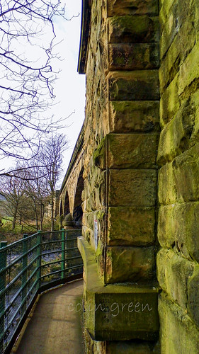
A scene that can never be repeated is this one of the Copley River (Toll) Bridge. The roof of St Stephen's Church can be seen with North Dean Woods behind.

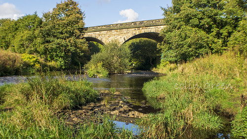
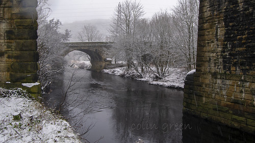
Copley River Bridge was a 2 arch stone bridge that carried North Dean Road across the River Calder. The bridge was was built by Richard Kennett-Dawson, the last Lord of the Manor of Copley. The bridge was constructed in 1831 and a fee was charged to cross, this was abolished in 1856. The bridge stood for 184 years until the Calder Valley was devastated by flooding on Boxing Day 2015. The bridge was badly damaged and eventually the decision was taken to demolish the remains. A replacement steel single span bridge was constructed and opened in 2017, the bridge was named Wilson Bridge after Graham Wilson who had lived in the toll house until his death in 2017. The new bridge only allows crossing for pedestrians, cyclists and horses, motorised vehicles are prohibited.

All the pictures except the toll price list can be seen on my Clickasnap account where they are full size, resolution and un-watermarked. Please take a moment to share and follow me on social media.

All images are the copyright of Colin Green, please credit me if using any of them.

Saturday, 4 July 2020

Copley (Manchester and Leeds) Viaduct, the Small One.

The Manchester & Leeds Copley Viaduct is the lesser known, and the older of the 2 railway viaducts that cross the River Calder on the eastern end of the village of Copley, West Yorkshire.

Copley Railway Bridge

The 3 Arch Copley Viaduct lies a few metres south of the more widely known 23 arch Lancashire & Yorkshire Railway Viaduct and was opened in 1840, 12 years earlier than it's bigger brother. The viaduct was built by George Stephenson and given  Grade II listed status on the 19th July 1988.
The line that crossers over the bridge was closed to passengers in 1970 when Brighouse Station was closed, although officially this came in to effect on the 1st September 1986. Between 1970 and May 2000 the line was only used for goods transport and the occasional passenger service on diversion. During the 1980's plans to single track the line across the 23 arch viaduct and completely close the line across the 3 arch viaduct were discussed occasionally, whilst this would have made a fantastic walkway from Milner Royd Junction to Greetland, Elland and Brighouse, I am of the opinion that a railway line is of much better use.

The following video features the images and can be seen here and on YouTube. Please take a moment to subscribe to my channel.


Summer and the Calder at Copley Railway Bridge

Copley Railway Bridge Through the Pillars

Copley Railway Bridge Arch

Clicking any image should open a link in another window to my Clickasnap Railway Pictures album.

Thansk for looking, please take a moment to share and follow me on social media.

Friday, 22 March 2019

Sowerby Bridge, Nearly Flooded Again.

On March 16th 2019 after many days of constant rain, the water levels of the Rochdale Canal and the Rivers Calder & Ryburn began to rise causing great concern amongst the residents of the town of Sowerby Bridge. The town was badly hit by flooding on Boxing Day 2015 and it still lingers in the memory of many people who were affected by this. These are video clips I took and have uploaded to YouTube of the night of the high water and the morning after when the town breathed a great sigh of relief.

The first video shows the town as the levels were rising.

And the next 2 show Mearclough Bridge and Sowerby Bridge Cricket Ground on the nights when the levels were rising and the morning after when the rivers were much lower.


Please take a moment to subscribe to my YouTube channel here. The more subscribers I get the more recognition is given to my channel. You can also follow me on Clickasnap, the worlds biggest, free to use, paid per view, image sharing site. I have over 1300 pictures viewable there. I can also be followed on Facebook, Flickr, Pinterest, Twitter and Tumblr via the links in the sidebar.

Thanks for looking and please take a moment to share.

Tuesday, 11 December 2018

Hollins Tunnel and Weir, Sowerby Bridge.

These are 2 short film clips I made recently and have uploaded to YouTube featuring clips to put together of the weir and tunnel at Sowerby Bridge known as Hollins.

Hollins Tunnel.
Hollins Tunnel or Hollins Mill Tunnel as it is also known is a canal tunnel that carries Hollins Mill Lane over it at Sowerby Bridge, West Yorkshire. Built over 200 years ago, the canal was opened in 1804 connecting the Calder & Hebble Navigation at Sowerby Bridge with the Bridgewater Canal at Manchester. The tunnel is the longest on the canal in Yorkshire and is quite an intimidating place in the dark. I filmed the clips at both ends and inside the tunnel on the 6th December 2018.


Hollins Mill Weir.
The weir at Hollins mill can be heard but barely seen from the canal tunnel, they are very close. The weir used to power the nearby mills that have long since been demolished and now stands as a monument to history. It was badly damaged during the devastating floods that hit the Calder Valley on Boxing Day 2015 with a large section now missing although this can't really be seen in the clips. I took these clips on the 6th December.


Please take a moment to subscribe to my YouTube channel and feel free to share.

You can follow me on Facebook, Flickr, Pinterest, Twitter and Tumblr via the links in the sidebar. You can also follow me on Clickasnap, where I currently have over a 1000 images to view and download. You can also subscribe to my YouTube channel here.

Thanks for looking and feel free to share. All links open in another window.

Through a Glass, Darkly: Hebden Bridge Railway Station in Negative

 There's something hauntingly beautiful about old photographs, especially when they're presented in a way that flips our perception....