Showing posts with label Flood. Show all posts

Saturday, 30 November 2024

Rochdale Canal Overflows in Sowerby Bridge

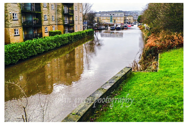
The 2015 Boxing Day floods marked a turning point for Sowerby Bridge, a town accustomed to the gentle rhythm of its waterways. For the first time in generations, the Rochdale Canal, once a vital artery of the local economy, was overwhelmed. The canal's banks gave way, flooding the towpath and inundating the locks. This historic event, coupled with the devastating impact of the Rivers Ryburn and Calder, forever etched itself into the town's memory.

These Polaroid photographs, preserved in timeless black and white, serve as a poignant reminder of the 2015 Boxing Day floods. The monochromatic format lends a historical and almost melancholic quality to the images, underscoring the enduring impact of this natural disaster.


The pictures displayed here are all in 900 x 600 x 150 resolution. Clicking any image should open a link in another window to my Colin Green Zazzle store where 6 x 4 x 300 prints are available for a small fee. This can be edited and added to additional products of your choosing.

Thanks for looking, all the pictures remain the copyright of Colin Green.


All links will open in another window.

Saturday, 8 October 2022

Sowerby Bridge, Boxing Day Floods 2015

 The following pictures which I recently rediscovered were taken of high water levels around Sowerby Bridge during the Boxing Day 2015 flooding that devastated the Calder Valley. This was the worst flooding to hit Sowerby Bridge since the 1960's with millions of pounds in property damage along the route of devastation along the River Calder from Todmorden to Mirfield and beyond. Mytholmroyd and Hebden Bridge suffered a lot more than Sowerby Bridge with the floods but living in Sowerby Bridge it was easier to picture some of the water levels here.

These pictures were taken using a Polaroid is2132 bridge camera on the 26th December 2015. They can be seen below and on Clickasnap full size, resolution and un-watermarked. Copies can also be purchased their if required.

The flooded Calder & Hebble Navigation and Rochdale Canals from Chain Bridge.

The Calder & Hebble overflowing at Chain Bridge.

Rochdale Canal from Tower Hill Bridge. The towpath can normally be seen to the
right of the canal, the small wall probably prevented the car park and nearby town
centre from further damage.

Tuel Lane Lock gates flowing over.

The River Calder flowing past Kingfisher Chase towards Lockhart Mills. The levels is
normally 15 - 20ft lower than this.

The flooded Kirkham Turn. This is where the Rochdale canal joins the Calder &
Hebble Navigation.

Flooding at Tuel Lane Lock on the Rochdale Canal.

Very High River Calder flowing past the Weaving Shed Apartments (right of picture) and
Dugdales Mill left of picture. Dugdales was severely flooded during this event.

River Calder at Gas Works Bridge, considering the damage done to Cromwell, Copley and
Elland Bridges, I was surprised that Gas Works Bridge still stood after the floods.

River Calder at Gas Works Bridge, looking more like a dam head than river crossing.

High level River Calder at Lockhill Mill, much of the red brick building was damaged beyond
repair by the flood and demolished the year after.

River Calder from above the Turks Head Beer Garden, the lower half of the iron footbridge
was just in to the flooded area. Dugdales mill storage yard can be seen heavily
flooded in the background.

Thanks for looking and please take a moment to share and follow me on social media.

All the pictures remain the copyright of Colin Green.

Sunday, 6 February 2022

Copley Toll Booth and Bridge, October 2013 Before the Floods that Destroyed It.

A small set of pictures taken with a Samsung Galaxy Tablet 27th October 2013, they were taken from the now demolished Copley Toll Bridge.

Copley Toll Booth

Copley Toll Booth is now a private residence that stands to the south of present day Wilson Bridge, but in 2013 stood at the end of the s arch stone Copley River (Toll) bridge. The booth was built circa 1831 when the bridge was constructed. This picture can be seen on my Clickasnap Profile un-watermarked, full size and resolution.

Fee structure for crossing the bridge.

The above fee board could be found on the side of Copley Toll Booth when I visited in 2013, I am not sure if the board is still there.


This picture taken stood towards the end of Copley River (Toll) Bridge shows the Toll Booth to the right, and to the left is the lych-gate to St Stephens Church, Copley. North Dean Woods can be seen beyond and the road heads in the direction of Norland and Greetland.


A scene that can never be repeated is this one of the Copley River (Toll) Bridge. The roof of St Stephen's Church can be seen with North Dean Woods behind.

Copley River Bridge was a 2 arch stone bridge that carried North Dean Road across the River Calder. The bridge was was built by Richard Kennett-Dawson, the last Lord of the Manor of Copley. The bridge was constructed in 1831 and a fee was charged to cross, this was abolished in 1856. The bridge stood for 184 years until the Calder Valley was devastated by flooding on Boxing Day 2015. The bridge was badly damaged and eventually the decision was taken to demolish the remains. A replacement steel single span bridge was constructed and opened in 2017, the bridge was named Wilson Bridge after Graham Wilson who had lived in the toll house until his death in 2017. The new bridge only allows crossing for pedestrians, cyclists and horses, motorised vehicles are prohibited.

All the pictures except the toll price list can be seen on my Clickasnap account where they are full size, resolution and un-watermarked. Please take a moment to share and follow me on social media.

All images are the copyright of Colin Green, please credit me if using any of them.

Friday, 22 March 2019

Sowerby Bridge, Nearly Flooded Again.

On March 16th 2019 after many days of constant rain, the water levels of the Rochdale Canal and the Rivers Calder & Ryburn began to rise causing great concern amongst the residents of the town of Sowerby Bridge. The town was badly hit by flooding on Boxing Day 2015 and it still lingers in the memory of many people who were affected by this. These are video clips I took and have uploaded to YouTube of the night of the high water and the morning after when the town breathed a great sigh of relief.

The first video shows the town as the levels were rising.

And the next 2 show Mearclough Bridge and Sowerby Bridge Cricket Ground on the nights when the levels were rising and the morning after when the rivers were much lower.


Please take a moment to subscribe to my YouTube channel here. The more subscribers I get the more recognition is given to my channel. You can also follow me on Clickasnap, the worlds biggest, free to use, paid per view, image sharing site. I have over 1300 pictures viewable there. I can also be followed on Facebook, Flickr, Pinterest, Twitter and Tumblr via the links in the sidebar.

Thanks for looking and please take a moment to share.

Monday, 19 November 2018

Venice: Day 1, 29 October 2018

Monday, October 29th, 2018. Our arrival in the fabled city of Venice was less a gentle gondola ride and more a wade into watery wonder. Instead of the postcard-perfect canals reflecting centuries of history, we were greeted by an altogether more dramatic scene: Venice submerged.

They say acqua alta, the high water, is a part of Venetian life. But the deluge that greeted us on our first day was something else entirely. Reports trickled in of the worst flooding in over a decade, the water levels in places, particularly around the iconic St. Mark's Square, creeping alarmingly close to three feet. The romantic notion of exploring the labyrinthine alleyways quickly dissolved into the more pressing reality of navigating a city rapidly turning into a temporary lagoon.

Our initial plans for a leisurely exploration were, shall we say, dampened. The heart of Venice, the areas we had dreamt of seeing first, were simply unreachable. Instead, our initial hours were spent confined to the periphery – the areas around the airport and our hotel becoming our unexpected initial playground.

But even in these less celebrated corners, the power and strangeness of the situation were undeniable. The familiar sounds of rolling suitcases were replaced by the slosh of water, the usual bustle punctuated by the lapping tide against doorways. Reflections danced on surfaces that should have been dry, turning ordinary streets into shimmering, albeit inconvenient, waterways.

Armed with whatever photographic tool came to hand – my trusty Sony phone for quick snaps, the surprisingly capable camera on my Amazon tablet, and my reliable Nikon D330 SLR for when conditions allowed – I tried to capture the surreal beauty of this unexpected introduction to Venice. These first images aren't of grand palazzos or bustling markets. They are a testament to the resilience of a city facing a formidable force of nature, a glimpse into the everyday adapting to the extraordinary.

They are pictures of a city holding its breath, waiting for the waters to recede, but even in its submerged state, radiating a unique and unforgettable charm. This wasn't the Venice we expected, but it was certainly a Venice we will never forget. Stay tuned for more as (hopefully!) the waters subside and we can venture deeper into the heart of this incredible, if currently very wet, city.

Clicking any of the images below should open a link in another window to my Colin Green Photography store on Zazzle.

Taken at the Venice airport boat moorings waiting for my transfer to the city.


This was my first proper land based view of Venice, taken from the boat landing area near
St Marks Square looking across the water to the church of San Giorgio Maggiore.

Looking down from my hotel room at San Marco Palace to the flooded courtyard below.

Flooding outside Doge's Palace at the entrance to St Mark's Square. The water got deeper than
this crossing the square, reaching chest height on me before I successfully reached my hotel.

The hotel steps.

I took this shortly after take off from Manchester Airport looking out across the Peak
District. The sun had not long since risen. At a guess I think the plane would have been
somewhere between Marple Bridge and New Mills.

The Hotel Steps again, looking up towards the sky light.

Looking down towards the Alps Mountain range somewhere near the borders of Switzerland,
Liechtenstein, Austria and Italy.

The rooftops of Venice viewed from my hotel room at San Marco Palace.

Thanks for looking and please take a moment to share and follow me on social media, and check out my portfolios on Photo4Me and Clickasnap via the links below.


All the pictures remain the copyright of Colin Green.

Through a Glass, Darkly: Hebden Bridge Railway Station in Negative

 There's something hauntingly beautiful about old photographs, especially when they're presented in a way that flips our perception....