Showing posts with label Moor. Show all posts

Saturday, 17 February 2024

Oxygrainz Bridges and Clough, Rishworth Moor

Amongst the heather-clad moors of Rishworth, on the edges of West Yorkshire, lies a hidden gem: Oxygrainz Clough and Bridge. This charming spot offers a peaceful escape for nature lovers and history buffs alike, combining stunning scenery with intriguing remnants of the past.

As you approach the clough, the ancient packhorse bridge, believed to date back to the 16th or 17th century, stands proudly, a silent witness to centuries of travellers and goods traversing the moors. Imagine weary traders leading laden horses across its weathered stones, carrying essential supplies between villages and markets. The historic bridge was replaced when the Oldham Turnpike was constructed a few metres to the north, allowing for larger goods traffic to cross between Lancashire and Yorkshire.

The clough itself unfolds like a verdant secret garden. A babbling brook meanders through moss-covered stones, whispering tales of a bygone era. Lush greenery carpets the banks, offering a vibrant contrast to the heather-dominated moors above. Sunbeams dance through the leaves, creating a magical, dappled light on the forest floor.

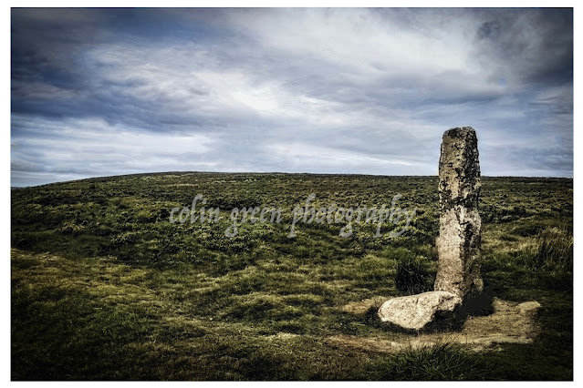
Your exploration doesn't have to end here. Rishworth Moor itself beckons with further adventures. Hike to the summit for panoramic views of the surrounding countryside, marvel at the ancient standing stones steeped in myth and legend, or visit the historic village of Rishworth with its charming pubs and traditional cottages.

The pictures below show the area around both bridges and the clough. They were taken in December 2020 with a Nikon d3300. The un-watermarked and higher resolution versions can be seen on Clickasnap by clicking any images (opens in another window).

The A672 Oldham Turnpike connects Oldham with Ripponden, the bridge replaced the much smaller Oxygrainz Bridge below which was once the packhorse route connecting the 2 towns.

Old and new, the original packhorse bridge, and the replacement turnpike bridge beyond.


Oxygrainz Clough flowing under the packhorse bridge and down Rishworth Moor, eventually reaching Booth Wood Reservoir.

The turnpike bridge viewed from the north side looking south. The M62 motorway is just beyond the hills peak.

Thanks for looking, please take a moment to check out my Zazzle Stores, portfolio on Photo4Me, and share and follow me on social media.

All the pictures remain the copyright of Colin Green.


All pictures open in another window.

Wednesday, 17 August 2022

Operation Starfish, Dummy Aerodrome at Sowerby, West Yorkshire 16 August 2022

 I previously visited the remains of the Operation Starfish Site on the 15th June 2015 and posted about that visit in an earlier post. Whilst passing on the 16th August 2022 and now in possession of a much better camera I decided to visit the scene again. I knew nothing much would have changed and apart from a bit more rubbish being left, and a bit of damage to the brick work outside nothing really has changed.

The pictures below were taken using a Nikon d3300 SLR and can also be seen full size, resolution and un-watermarked on my Clickasnap account. The text below the pictures is taken from my post dated 3rd February 2018 featuring the images taken in 2015.


The blast door pictured in front of the bunkers main entrance

Inside the bunker on the left hand side of the entrance is this former control
room. Now filling up with rubbish that has been left behind.

Looking north over the bunker. In the foreground can be seen some
brickworks, probably housed washrooms and generators. Their isn't much
evidence of the site ever being linked to mains electric.


The former control room to the right hand side of the entrance.

Looking west away from the bunkers entrance, taken from the roof I
assume the site in front of me would have housed the metal pans
that created the dummy lighting effect.

The following text is taken from my previous post on the Operation Starfish plans.

Operation Starfish was a large scale 2nd World War decoy plan to fool German bombers in to dropping their payloads in the wrong areas. The plan was developed by Colonel John Turner after the near destruction of Coventry in November 1940. The sites were developed in the countryside approx. 4 miles from what were considered targets for the German bombers. The surrounding fields usually had a metal trough through the undergrowth which would be filled with a mixture of creosote, coal, diesel oil and set alight when bombers were in the area, after a short time of usually 15mins water would be added to create an explosion and a burst of flame fooling the overhead bombers in to thinking that it was the target after the initial bombs had dropped.

The site at Sowerby was developed as a decoy for the cities of Manchester and Leeds as well as the railway goods yards at, Greetland, Halifax, Todmorden, Littleborough and Rochdale. The site had a 2 room bunker which is still standing, which was entered through a short passage behind a blast wall.

Thanks for looking and please take a moment to share and follow me on social media.

All the pictures remain the copyright of Colin Green

Monday, 5 April 2021

Churn Milk Joan, A Moorland Mystery

Standing sentinel on Midgley Moor, overlooking the breathtaking Calder Valley, is a stone steeped in history and legend. Known by many names – Churn Milk Joan, Churn Milk Peg, and Nelmires Stoop – this imposing 7ft monolith has watched over the valley for centuries, its origins shrouded in time.

First recorded in the 17th century, the stone is believed to have served as a boundary marker, a silent witness to the ebb and flow of life across the moors. But its more colourful name, Churn Milk Joan, didn't appear until the early 1800s, and with it came a tale as chilling as the moorland wind.

Local legend whispers of a milkmaid, caught in a ferocious snowstorm, who tragically froze to death while crossing the treacherous moor from Peckett Well to Luddenden. They say the stone was named in her memory, a poignant reminder of the harsh beauty and unforgiving nature of the landscape.

But Churn Milk Joan isn't just a monument to tragedy. It's also a source of local folklore and superstition. Legend has it that placing a penny in the hollow atop the stone will bring you good luck. And if you're brave enough to venture to the moor on New Year's Eve, you might witness a truly magical spectacle. They say that as the bells of St. Michael's Church in Mytholmroyd echo across the valley, the stone itself spins three times! A captivating thought, especially considering the stone predates the church by a couple of hundred years. What secrets has it witnessed in its long vigil?

So, the next time you find yourself exploring the Calder Valley, take a detour to visit Churn Milk Joan. Stand in its shadow, feel the wind whipping across the moor, and let your imagination wander. Is it just a boundary marker? A memorial to a lost milkmaid? Or a magical stone with the power to grant good fortune? Perhaps it's a little bit of all three, a testament to the rich tapestry of history and folklore woven into the very fabric of the Yorkshire landscape.

The picture was taken on the 5th April 2021.

Clicking the image should open a link in another window to the un-watermarked, higher resolution version on Clickasnap.

Thanks for looking, please take a moment to share and follow me on social media.

Thursday, 11 June 2020

Fly Flatts, Warley and Ovenden Moors October 2013

Warley Moor is an area of open land approx. 6 miles north of Halifax on an old road route to Haworth, another 3 miles north of Warley Moor. The area lies just above the village of Wainstalls in an area known locally as Top Withins. The area is stunning and there have been many times I have been there and it seems to have it's own climate, it lies approx. 1440ft above sea level and I have known it sunny and calm when I have left my house down the valley at Sowerby Bridge and rainy and stormy when I have arrived at Warley Moor. The area is known locally by a number of different names, Them being Fly Flatts, Top Withins and Ovenden Moor.

As well as the outstanding moorland giving unbeatable views across the Calder, Hebble and Oxenhope Valleys, the moor is also home to Warley Moor Reservoir and Ovenden Moor Windfarm.

These pictures were taken on the 5th October 2013 using a Samsung Galaxy Tablet, they can be seen below or on Clickasnap full size, resolution and un-watermarked.

Warley Moor Reservoir


Completed in 1872 after a near 8 year build Warley Moor Reservoir or Fly Flatts as it is also known was built on behalf of the Halifax Waterworks Extension Scheme. When full it covers 68 acres, has a depth of 45 feet and holds approx. 193 million gallons. It is known owned and maintained by Yorkshire Water and the home of Halifax Sailing Club, established in 1959 the reservoirs high elevation makes them the highest sailing club in Britain.

Ovenden Moor Wind Farm


Opened in 1993 at a cost of £12 million, they site had 23 turbines when completed. Controversial when opened due to the turbines being in an area of outstanding natural beauty overlooking Bronte Country, and the Calder & Hebble Valleys the original turbines were expected to have a life span of 25 years and generate enough power for approx. 5500 homes. These were decommissioned in 2015 and replaced by 9 turbines with the power to generate more electricity, an estimated 11000 homes can now be powered from here.
  

The video below shows a number of pictures taken around the moor on a number of visits including this one on the 5ht October 2013.


Thanks for looking and please take a moment to share and follow me on social media. All the images can be purchased and viewed on Clickasnap.

All the pictures remain the copyright of Colin Green. 

Sunday, 21 October 2018

Beneath a Halifax Sunrise: A Stroll Across Savile Park

 The air was crisp, carrying the faint scent of damp earth and the promise of a new day. Yesterday morning, under the soft glow of the nascent sun, I found myself wandering across the familiar expanse of Savile Park in Halifax. Or should I say, The Moor? Skircoat Moor? Skircoat Common? This beloved green lung of our town answers to many names, each echoing a piece of its rich tapestry.

More than just a park, Savile Park breathes history with every rustle of leaves. As I walked, the stories embedded in this land seemed to rise with the morning mist. Imagine, this very ground, now a haven for runners and dog walkers, was once the vision of the Savile Family, who wisely decreed it should forever remain open, a gift of green to the community. Their foresight has gifted us generations of open space, a place where the spirit of Halifax has played out in countless ways.

Think of the roar of the crowds at the Halifax Agricultural Show, the thud of boots during Rugby League and Football matches, the determined strides of Crossley Heath students carving paths across the moor. This land has witnessed celebrations, competitions, and the simple joy of open-air activity.

But the echoes of history run deeper still. My mind wandered back to the dark days of World War II, when this very turf was transformed into a vital "Dig for Victory" garden, feeding a nation facing hardship. It's humbling to picture the dedication of those who turned this recreational space into a source of sustenance.

And then there's the grandeur of the Great Yorkshire Show, which graced this very spot on at least four occasions, bringing the best of the region to our doorstep. It speaks volumes about the scale and importance of Savile Park in the wider Yorkshire landscape.

As I continued my walk, the landmarks that frame this historical haven came into view. To the west, the impressive facade of Crossley Heath School stands sentinel, a long-time neighbour and beneficiary of the park's open spaces. To the east, the manicured beauty of Manor Heath Park offers a contrasting, yet complementary, landscape. And nestled in the north-eastern corner, the elegant Thorp Fountain stands as a silent witness to the park's enduring presence.

These fleeting moments, captured through the lens of my trusty Nikon D3300 back on the 20th of October 2016, are more than just pretty pictures. They are glimpses into a place that has been shaped by generations, a place where the echoes of the past mingle with the present-day rhythms of life.

Savile Park, whatever name you choose to call it, is more than just grass and trees. It's a living testament to community, resilience, and the enduring power of open spaces. It's a place to walk, to breathe, to remember, and to appreciate the rich history beneath our feet, especially when bathed in the soft light of a Halifax sunrise.

Clicking any of the images below should open a link in another window to My Colin Green Photography store on Zazzle. 


The Twin Towers of King Cross, to the right is Wainhouse Tower, and the clocktower to the left is part of the Crossley Heath School Building.


To the north east corner of Savile Park is the Thorp Fountain, the Grade II listed drinking fountain was given to the people of Halifax by Joseph Thorp and unveiled in July 1869, Thorp also donated a drinking fountain which can be found in the grounds of the nearby People's Park. The fountain which is no longer in use bears the inscription "Thank God for water - water is best" and was designed by Levi Gill a stone mason who was born in Pateley Bridge before moving to Halifax. The Fountains Grade II listed status was granted on the 23rd November 1973. The fountain can be seen below.


St Jude's Church can be seen in the background.

Thanks for looking, please take a moment to share and follow me on social media, and please take a moment to check out my portfolios on Photo4Me and Clickasnap via the links below.


All the pictures remain the copyright of Colin Green.

Saturday, 20 January 2018

Whispers of Wind and Stone: Stoodley Pike (October 2013)

Imagine standing atop a windswept hill, the vast expanse of the Calder Valley stretching out before you like a rumpled green carpet. The air is crisp, the silence broken only by the rustling of heather and the distant bleating of sheep. This isn't just any hill; it's Stoodley Pike, a sentinel of the South Pennines, and its crown jewel is the imposing monument that pierces the skyline, a testament to history and resilience.

Stoodley Pike, rising approximately 1300 feet (400 meters) above the villages of Mankinholes and Lumbutts, isn't merely a geographical feature. It's a living chronicle, a place where time folds in on itself. The monument, visible for miles, whispers tales of Napoleonic battles and Crimean conflicts.

But let's rewind a bit. This isn't the first monument to grace this lofty perch. The original, erected in 1815 to celebrate the defeat of Napoleon, succumbed to the harsh Pennine weather and a dramatic lightning strike. It’s even speculated that a monument was present before this. The replacement, designed by James Green and completed in 1856 as the Crimean War ended, stands further from the edge, a lesson learned from its predecessor’s demise.

And what a replacement it is! A formidable stone structure, it houses a spiral staircase that ascends to a balcony, offering panoramic views that will steal your breath away. The climb, however, is not for the faint of heart. 39 steps plunge into near-total darkness, a stark contrast to the brilliant landscape outside. A torch is an absolute must – the "light-enhancing" grill is, as I've found, more of a decorative feature.

As you stand at the entrance, facing north, a faded inscription etched in stone tells a story of war, peace, and strange coincidences:

STOODLEY PIKEA

BEACON MONUMENT

ERECTED BY PUBLIC SUBSCRIPTION

COMMENCED IN 1814 TO COMMEMORATE

THE SURRENDER OF PARIS TO THE ALLIES

AND FINISHED AFTER THE BATTLE OF

WATERLOO WHEN PEACE WAS ESTABLISHED IN 1815.

BY A STRANGE COINCIDENCE

THE PIKE FELL ON THE DAY THE RUSSIAN

AMBASSADOR LEFT LONDON BEFORE THE

DECLARATION OF WAR WITH RUSSIA IN 1854.

WAS REBUILT WHEN PEACE WAS RESTORED IN1856.

RESTORED AND LIGHTNING CONDUCTOR FIXED IN1889.

This inscription is more than just words; it's a tangible link to the past, a reminder of the turbulent times that shaped our world. The fact that the original monument fell on the eve of the Crimean War is a chilling example of history's uncanny echoes.

Despite its exposed position and frequent lightning strikes, the monument stands strong, a testament to the skill of its builders and the addition of a lightning conductor in 1889. It's a symbol of enduring strength, a beacon in the wild landscape.

My own visit, captured in the photos taken with a Samsung Galaxy Tablet on October 19th, 2013, only scratched the surface of Stoodley Pike's allure. This isn't just a place to visit; it’s a place to experience, to feel the wind whip around you and to imagine the countless generations who have stood on this very spot, gazing out at the same breath taking view.

So, if you find yourself in West Yorkshire, take the time to explore Stoodley Pike. Climb the dark staircase, read the faded inscription, and let the whispers of wind and stone transport you to a different time. You won't just see the Calder Valley; you'll feel its history, its resilience, and its enduring beauty.

Clicking any of the images below should open a link in another window to my Colin Green Photography store on Zazzle.


Thanks for looking, please take a moment to share and follow me on social media, and check out my portfolio on Photo4Me via the link below.


All the pictures remain the copyright of Colin Green.

Saturday, 2 September 2017

Across the Pennines: A Time-lapse Drive on the M62

Ever wondered what it's like to drive across the highest stretch of motorway in Britain? This time-lapse film offers a unique perspective on the M62, specifically the challenging section between West Yorkshire and Greater Manchester. Filmed on September 1st, 2017, the journey begins at Ainley Top and climbs to the dizzying heights of Rishworth Moor, reaching 1221 feet (372 metres) above sea level near junction 22. This monumental feat of engineering, completed in 1970 after years of planning and construction, traverses some of the most unforgiving terrain in the UK. Notice how the clear skies at the start of the film quickly give way to a thick blanket of fog as we approach Saddleworth. This dramatic weather shift highlights the very conditions that plagued the construction of this section of the M62, making it one of the most complex and costly stretches of motorway ever built. The accompanying music, "Cylinder Seven" by Chris Zabriskie, adds an atmospheric layer to this fascinating glimpse into the challenges of building on the "roof of England."


The video was doubled in speed as I was driving a truck, and whilst it may look dangerously close at some points to the Abbey trailer, I wasn't, and at that point he was really struggling for power as we were barely doing 40mph and I couldn't get out to pass.
 
A few notable points of scenery, blink and you'll miss some to look out for, and the time in view,
 
Outlane Junction 23 slip road and Outlane Golf Club 1:30
Scammonden (Rainbow) Bridge 2:42
Scammonden Reservoir and Water Tower 3:01
Rishworth Moor, 3:38
Stott Hall Farm is barely visible to the right of the picture (3:46).
The fog comes into view and reduces the long-range visibility (4:37).
Junction 22 Saddleworth 5:58
Highest Motorway in England, Sign 6:08
M62 Pennine Way Bridge, 6:18
Rakewood Viaduct (Windy Hill) 7:38

Through a Glass, Darkly: Hebden Bridge Railway Station in Negative

 There's something hauntingly beautiful about old photographs, especially when they're presented in a way that flips our perception....