Showing posts with label Mountains. Show all posts

Sunday, 6 March 2022

Above the Pyrenees

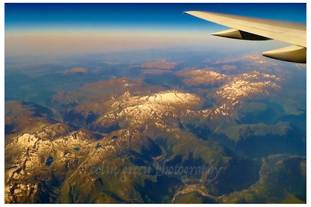
 Above the Pyrenees is a set of 5 pictures taken in July 2014 whilst on a flight. The Pyrenees are a mountain range that straddle the border between France and Spain, the Principality of Andorra also exist within the mountain range. The area I was over when taking the pictures is known as the Natural Park of Posets-Maladeta which is in the Huesca, Aragon region of Northern Spain.

The pictures were taken on Thursday 17th July 2014 using a Polaroid is2132 bridge camera. They can be seen below and on ClickASnap where they are full size, resolution and un-watermarked.


Thanks for looking and please take a minute to share and follow me on social media via the links in the sidebar.

Clicking any image should open a link in another window to the version displayed on Clickasnap.

All pictures remain the copyright of Colin Green.

Sunday, 21 June 2020

The England Scotland Border Crossing at Carter Bar.


Carter Bar can be found on the A68 road at the top Redesdale Valley at a height of 1371ft above sea level. It is approx. 58 miles south east of Edinburgh, and 45 miles north west of Newcastle. The nearest town being Jedburgh.


Carter Bar has a viewing are which is popular with passes by who tend to stop and picture the stunning landscapes visible from the crossing. There are 2 large stones to mark the actual historic border between England and Scotland. The Cheviot Hills, Scottish Borders and Northumberland can be viewed for many miles and the crossings exposed placing and altitude means it can be quite cold on a summers day, and still snowy into late spring and early autumn.

On the 7th July 1575 Carter Bar was the scene of the last major battle between the Kingdoms of England and Scotland, this became known as the Raid of Redeswire. The area was also known to hold Truce Days, also known as March Law. This was a system of international law to settle cross border disputes between England and Scotland, attended by the Lord Warden of the Marches who was responsible for the security of the border regions. These became unnecessary after 1603 when the union of the crowns led to  King James VI of Scotland being crowned King James I of England.

The full set of pictures can be seen below and on Clickasnap un-watermarked. They were taken with a Nikon d3300 SLR camera on the 24th October 2018.


Thanks for looking and please take a moment to share and follow me on social media.

All the pictures and video remain the copyright of Colin Green.

Sunday, 17 May 2020

Timanfaya National Park, Lanzarote

Timanfaya National Park was a trip I took in July 2013. The visit was part of a tour of the island of Lanzarote of which it has to be said I had little enthusiasm for. They visit to Lanzarote was something that my wife and daughter planned and in the lead up to it was something I looked forward to less and less, I will admit now I was wrong, the island being one the places I have enjoyed visiting the most and look forward to one day getting the opportunity to revisit. One of the many highlights of the trip was the day we took the tour of the island which included the visit to Timanfaya. I did not know what to expect upon the visit as I was aware that the area was still home to an active volcano, but despite the disappointment of finding whilst active there was no lava flowing or bubbles to view the trip was still worth it. There were demonstrations of how close the heat was to the service and a look inside the El Diablo Restuarant, where you could see the food being cooked over an open well of heat.

Please take a moment to view and subscribe to my YouTube channel to see more videos like this.

Timanfaya National Park was established in 1974 and covers an area 19.72 square miles of the south western area of Lanzarote. The park is regulated with only selected areas open to the public and most viewable only via a coach trip. There is an area for visitors to take camel rides and a restaurant for refreshments when visiting. It was along with the rest of Lanzarote designated a UNESCO  Biosphere Reserve in 1993. This is to protect the unique flora and fauna that can be found on the park.

The Volcano whilst active is considered dormant, the last eruption being in 1824. The greatest eruptions to hit the island were through a 6 year period from 1730 until 1736 when much of the landscape around the park was created. During this period the island lost the villages of Tingfa, Mancha Blanca, Maretas, Santa Catalina, Jaretas, San Juan, Timanfaya, Rodeo and Mazo, and much of the land covered by volcanic ash was the most fertile upon the island so it was a time of great hardship. The land is considered to be of great interest to science as it's one of the newest places on earth and they are interested to see how it develops with no major human interaction.

Whilst the volcanic activity is still active, this activity happens just below ground where temperatures can reach between 100 to 600 centigrade at a depth of 13 metres. The park offers a geyser demonstration to show how hot the below surface temperature is. The following video shows the demonstration.


The pictures and video were taken using a Samsung Galaxy Tablet. They can be seen below or alternatively on Clickasnap full size, resolution and un-watermarked.
The Fire Pit is used as a demonstration to show how hot the temperature is
just underneath the surface of the park.


The parks restaurant can be seen to the left of the crater.

El Diablo, created by Cesar Manrique is the symbol of
Timanfaya National Park.


The restaurant uses geothermal heat channelled through open pits like this
to cook the food served.


Thanks for looking and please take a moment to follow me and share on social media.

Clicking any image should open a link in another window to the un-watermarked, full resolution image on Clickasnap.

All the pictures and video remain the copyright of Colin Green.

Saturday, 21 October 2017

Journey Through Cumbria and Scotland: A Dashcam Time-Lapse

Experience the beauty of one of the UK's most scenic motorway stretches in this captivating time-lapse video! Filmed from my dashcam, this journey takes you on a 75-mile trip through stunning landscapes, from the edge of the Lake District to the Scottish border.

Our adventure begins near Burton in Kendal Services, just inside Cumbria, as we cross over from Lancashire. From there, we travel north on the motorway, offering glimpses of rolling hills and majestic mountains, even under less-than-ideal weather conditions. Keep an eye out for the dramatic climb to Shap Summit and the exhilarating descent that follows! The anticipation builds as we approach and cross the Scottish border, marking a transition into new territory.

This time-lapse condenses approximately 1 hour and 20 minutes of driving into a fast-paced 8-minute journey. The original footage was captured on Monday, October 16, 2017, using a Vivitar DVR 783HD waterproof action cam.


These dash cam and scenic view videos are a new venture for me, a way to explore different aspects of visual storytelling beyond still photography. I hope you find them interesting. In this video, the camera is fixed facing north, but future uploads will feature angled shots showcasing more of the surrounding scenery.

Through a Glass, Darkly: Hebden Bridge Railway Station in Negative

 There's something hauntingly beautiful about old photographs, especially when they're presented in a way that flips our perception....