Showing posts with label Mytholmroyd. Show all posts

Saturday, 10 February 2024

Hawksclough Bridge, Mytholmroyd

Nestled amidst the rolling hills of the Calder Valley, in the charming Yorkshire village of Mytholmroyd, lies the Grade II listed Hawksclough Bridge. This seemingly unassuming structure, crafted from the warm embrace of local sandstone, is more than just a passage over the River Calder. It's a bridge woven with myth, whispered secrets, and the echoes of a bygone era.

As you stand upon its weathered stones, the gentle gurgle of the water below serenades you, transporting you back in time. Legend has it that the bridge was built by the devil himself, enticed by a wager with a local builder. The deal? The bridge's completion within a night was in exchange for the builder's soul. But as the rooster crowed, signalling the dawn, the bridge remained unfinished, just one stone short. The devil, cheated of his prize, vanished in a puff of brimstone, leaving behind the incomplete bridge as a testament to his trickery.

While the truth behind the bridge's construction is likely less fantastical, the myth adds a touch of magic to its history. It's a reminder that even the most ordinary structures can hold extraordinary stories, waiting to be unraveled by the curious mind.

But Hawksclough Bridge is more than just a relic of the past. It's a vibrant part of the Mytholmroyd community. Children clamber along its edges. Artists capture its rustic beauty in their paintings, and photographers find endless inspiration in its weathered nooks and crannies.

Below are a set of pictures taken at the bridge with a Nikon d3300 in July 2024.


Thanks for looking, please take a moment to share and follow me on social media, check out my stores on Zazzle and portfolio on Photo4Me via the links below.


All the pictures remain the copyright of Colin Green.

Sunday, 21 January 2024

Vintage Rochdale Canal Images.

The pictures below were taken on the Rochdale Canal between Hebden Bridge and Mytholmroyd in November 2013. I've edited them to give the impression of a vintage photograph with vignette and noise added to increase the effect.

They were taken using a Samsung Galaxy Tablet on November 2nd 2013, they can also be seen on Clickasnap un-watermarked and higher resolution.

Lock 7 Broad Bottom can be found on the canal near the point where Burnley Road crossers over the canal, a short distance from what was once the site of Walkley Clogs. The lock is Grade II listed having been given this status on the 21st June 1984.

Mayroyd Moorings, Hebden Bridge pictured from Station Road Bridge.

Broad Bottom Lane Bridge pictured from Broad Bottom Lock 7, Mytholmroyd.

Bridge 12, Westfield Terrace Bridge, the canal had been drained for a stretch here, I can not remember why and for how far it stretched.

Mayroyd Bridge near the moorings at Hebden Bridge.

Thanks for looking, please take a moment to check out my stores on Zazzle, my portfolio on Photo4Me and to share and follow me on social media.


All the pictures remain the copyright of Colin Green.

Sunday, 22 October 2023

Memorial and Rain, Brearley

The following pictures were taken whilst walking the route 66 cycleway through Brearley, West Yorkshire. I'd set off to walk a loop from my home in Sowerby Bridge, down the valley from Sowerby through Boulderclough, and in to Mytholmroyd before returning along route 66 and the Rochdale Canal towpath.

Along the route, as you pass through Brearley, you pass the murder stone just north of the railway bridge. The stone is a memorial to William Deighton, a tax inspector who was killed in Halifax while investigating "King" David Hartley and his coiner gang. I have previously posted more on the memorial.

The path is part of the Route 66 cycleway (bridleway), with the railway bridge seen at the top of the picture and the green metal wall.

Underneath the skeletal artwork reads the following:A full and true account of a barborous, bloody, and inhuman murder. There is further artwork below this writing.

Carrying on my walk past the former chapel, now apartments, and through the centre of Brearley, the rain came, and trying to avoid soaking, I sheltered underneath Wheatley Royd Farm Bridge. This didn't work out as planned after nearly 30 minutes of waiting for my weather app to update to tell me it was going to be at least another hour, so I carried on with the walk and the soaking. The following two pictures were taken underneath the shelter of the bridge.


Clicking any image should open a link in another window to the higher-resolution, un-watermarked version on Clickasnap.
 
Thanks for looking; please take a moment to share and follow me on social media.
 
All the pictures remain the copyright of Colin Green.

Sunday, 15 October 2023

St Michael's Church, Mytholmroyd

 Mytholmroyd Parish Church, better known as St Michael's Church was consecrated on the 8th September 1848. Built as part of the Million Pound Church act, a scheme officially known as the 1820 Church Building Act, that was intended to start a program of building churches in growing areas. The act was created after research had shown that few new churches had been built since the era of Queen Anne who had died in 1714. The act saw the government contribute over £1.1 million and public subscription raise an additional £1.9 million. Churches built to minimum budgets and became known as Commissioners Churches, Million Pound Churches or Waterloo Churches, a large amount of the money raised being taken from the war indemnity after the Napoleonic Wars.

St Michael's was extended in 1888, with a 2 storey Sunday School following soon after, this was reduced to 1 storeyand converted to the church hall in the 1970's. The church was badly flooded in the 2015 Boxing Day Floods, levels reaching a height of over 4 feet and forcing a closure that lasted for almost 2 years. This was the first significant flooding at St Michaels since the 1940's and has led to more flood prevention work taking place along the banks of the River Calder.

I took theses pictures with a Samsung Galaxy Tablet on the 26th October 2013, I have replaced the sky as the original picture showed a washed out lifeless one.


The River Calder flowing past St Michael's, a little over 2 years later the river burst its banks and rose to approx 4ft above the floor of the church. The buildings to the left were so severely damaged they were demolished shortly after and now it is an open space between Burnley Road and the River.


Clicking any image should open a link in another window to the un-watermarked, higher resolution version on Clickasnap.

Thanks for looking, please take a moment to share and follow me on social media.

All the pictures remain the copyright of Colin Green.

Saturday, 29 October 2022

Saint John in the Wilderness, January 2015

The Church of Saint John in the Wilderness has served the community of Cragg Vale since 1817. The church is also known as Cragg Church and Marshaw Bridge Church and sits across Cragg Brook from the Hinchcliffe Arms.

The current church that occupies the site was opened in 1839 funded by the million pound act at a cost of £2130. It was built to replace the earlier church on the site which had opened in 1817, a few years after the foundation stone had been laid in March 1813. This earlier church had accommodated 250 worshipers but is larger replacement could now house 800. This was useful when the church was responsible for control of the area as the vicar had the power to force people to attend services and often demanded people leave the nearby pubs to do so.

In 1844 the church was given independence from the Parish of Halifax and the prominent local Hinchcliffe family became more involved with the church, donating and supporting the church in funds and activities. A number of the families graves can be seen within the grounds. It is said the church was visited by the Bronte Family often, this could be due to Branwell Bronte's time spent working as a clerk at the nearby Luddenden Foot Railway Station. Another famous although now notorious celebrity with links to the church is Jimmy Saville who was made an honorary church warden in 1967.

The pictures were taken using a Polaroid is2132 bridge camera on the 10th January 2015. They can be seen here and on Clickasnap.


Thanks fro looking, please take a moment to share and follow me on social media.

All the pictures remain the copyright of Colin Green.

Wednesday, 12 October 2022

Mytholmroyd Railway Station October 2013

 Mytholmroyd Railway Station was opened in May 1847 by the Manchester & Leeds Railway with temporary platforms and buildings, several years after the railway was completed through the Calder Valley. These temporary buildings were replaced by a new station with platforms overhanging Mytholmroyd Viaduct in December 1871 and thats how things remained for over 100 years. In the 1980's some of the buildings that overhung the viaduct were removed, in 1985 the station became an unstaffed stop, and by the decades end the Grade II listed former ticket office and entrance had been bordered up and closed, after new platforms were constructed to the eastern end of the station, the platforms overhanging the viaduct were also removed around this time.

Mytholmroyd Station has limited facilities including a small car park, bus shelter cover on each platform and electronic ticket machines. No refreshment or toilet facilities can be found at the station. In the last full years of passenger numbers the station was used by 45912 passengers. This was for the year 2020/21 during the covid pandemic and was an approx average of 882 per week, down from an average of 3884 per week pre covid.

These pictures were taken using a Samsung Galaxy Tablet on the 26th October 2013. They can be seen below or on Clickasnap full size, resolution and un-watermarked.


Thanks for looking and please take a moment to share and follow me on Social media.

All the pictures remain the copyright of Colin Green.

Sunday, 5 June 2022

Artworks of Calderdale

 Artworks of Calderdale if a YouTube slideshow of over 50 drawings, sketchers and art images based on photographs by me and some historical images of photo's and postcards by others. Many areas of Calderdale feature and much architecture and scenes are also shown within the video. The images are all set to music by Strauss and Liszt. 


Images 1,2,5,6,8,12,15,18,19,23,26,28,31,32,34,36,37,38,40,41,43,45,46,47,48,49,51 and 53 are based on photographs by me and the full copyright belongs to me.

All the other images featured are based on postcards and photographs taken by others, the original copyright remains theres, the artwork copyright is mine. I am happy to credit them if required.

Please take a moment to subscribe to my YouTube channel

Saturday, 26 March 2022

Churn Milk Joan Artwork

 I previously posted the picture Churn Milk Joan in April 2021 and provided the following information alongside it,

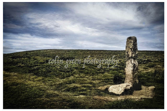
Churn Milk Joan is a standing stone upon Midgley Moor overlooking the Calder Valley. Also Known as Churn Milk Peg and Nelmires Stoop it reaches a height of approx 7ft and is thought to have been erected as a boundary marker, having been recorded as early as the 17th Century.

The stone is thought to have been given the name Churn Milk Joan in the early 19th Century, as a tribute to a milkmaid who froze to death whilst crossing the moor from Peckett Well to Luddenden during a heavy snow storm. Some of the legends said about the stone include leaving a penny in the depression on top of the stone is said to bring you good luck, it is also claimed that the stone spins 3 times on New Years Eve when the sound of the St Michaels Church bells, Mytholmroyd can be heard around it, the stone is thought to predate the church by a couple of hundred years.

Clicking the image should open a link in another window to the un-watermarked, higher resolution version on Clickasnap.

Thanks for looking, please take a moment to share and follow me on social media.

Monday, 5 April 2021

Churn Milk Joan, A Moorland Mystery

Standing sentinel on Midgley Moor, overlooking the breathtaking Calder Valley, is a stone steeped in history and legend. Known by many names – Churn Milk Joan, Churn Milk Peg, and Nelmires Stoop – this imposing 7ft monolith has watched over the valley for centuries, its origins shrouded in time.

First recorded in the 17th century, the stone is believed to have served as a boundary marker, a silent witness to the ebb and flow of life across the moors. But its more colourful name, Churn Milk Joan, didn't appear until the early 1800s, and with it came a tale as chilling as the moorland wind.

Local legend whispers of a milkmaid, caught in a ferocious snowstorm, who tragically froze to death while crossing the treacherous moor from Peckett Well to Luddenden. They say the stone was named in her memory, a poignant reminder of the harsh beauty and unforgiving nature of the landscape.

But Churn Milk Joan isn't just a monument to tragedy. It's also a source of local folklore and superstition. Legend has it that placing a penny in the hollow atop the stone will bring you good luck. And if you're brave enough to venture to the moor on New Year's Eve, you might witness a truly magical spectacle. They say that as the bells of St. Michael's Church in Mytholmroyd echo across the valley, the stone itself spins three times! A captivating thought, especially considering the stone predates the church by a couple of hundred years. What secrets has it witnessed in its long vigil?

So, the next time you find yourself exploring the Calder Valley, take a detour to visit Churn Milk Joan. Stand in its shadow, feel the wind whipping across the moor, and let your imagination wander. Is it just a boundary marker? A memorial to a lost milkmaid? Or a magical stone with the power to grant good fortune? Perhaps it's a little bit of all three, a testament to the rich tapestry of history and folklore woven into the very fabric of the Yorkshire landscape.

The picture was taken on the 5th April 2021.

Clicking the image should open a link in another window to the un-watermarked, higher resolution version on Clickasnap.

Thanks for looking, please take a moment to share and follow me on social media.

Tuesday, 26 February 2019

Railway Stations of Calderdale Past and Present.

Railway stations of Calderdale is a short YouTube video - slideshow I put together featuring pictures from the public domain of nearly every railway station that has ever served an area of Calderdale. Of all the stations there were only 4 I was unable to find pictures of which were Brighouse Clifton Road, Halifax Shaw Syke, Rochdale Road Halt (Stainland Branch) and West Vale Station. I managed to get 1 picture of every other station and there is also a picture of every station open today. The opening and closing dates are included with each picture as well as the estimated re-opening date for Elland which is currently 2022.

It sadly shows what a magnificent railway heritage we chucked away in this area, as of the closed stations only Elland and potentially Hipperholme are ever likely to reopen. Had we land banked the closed lines and stations we could have potentially been looking at re-opening the Queensbury Lines with Holmfield or Ovenden Stations giving an extra route to the north via Keighley, The Pickle Bridge line with Baliff Bridge or Clifton Road Stations giving extra capacity on the line between Huddersfield and Bradford. We could also be looking at adding extra stations at Luddendenfoot, Cornholme or Portsmouth (Lancs) and Norwood Green or Lightcliffe to reduce congestion on the roads.

Anyhow here is the video of our railway station heritage in Calderdale.

I feature videos like this amongst many other different ones on my YouTube channel here. Please take a moment to subscribe and help support my channel.

You can also follow me on Facebook, Flickr, Pinterest, Twitter and Tumblr via the links in the sidebar. I also have a profile on Clickasnap, the worlds biggest, free to use, paid per view, image sharing site. Click here to have a look.

Thanks for looking and please take a moment to share.

Friday, 4 January 2019

The Train Trip, Sowerby Bridge to Mytholmroyd.

A short video I recently did of the view outside the window as I took a train journey from Sowerby Bridge to Mytholmroyd. The trip was taken on New Years Eve 2018 at about 11.15am so the train wasn't overly busy. I didn't intend on filming it but as it was on the tripod already, I thought why not and set it going. I filmed it on my Nikon d3300 SLR.

The journey starts at Sowerby Bridge Railway Station Platform 1 and heads west firstly past County Bridge, Town Hall Clock and the River Calder. After this we passed Goodalls Transport which is built on part of the site of the former goods yard and near to where the original Sowerby Bridge Railway Station was sited until moving to it's current location in 1876. The train then enters Cemetery Tunnel, which is also known as Sowerby Tunnel or locally as Dixy Tunnel. The tunnel runs under Dixon Scar Woods and Sowerby Bridge Cemetery. I trimmed the tunnel section of the video to a few seconds as we were in the tunnel for a minute.

Once through the tunnel, the open country becomes visible as the train heads towards the Tenterfields area of Sowerby Bridge, a mill complex converted to business units. After this is the former VTL works now a caravan storage area which forms part of Fairlea Mills, with a little bit further the area that was Luddendenfoot Railway Station, which also is now Station Road Industrial Units.

After passing Luddendenfoot, once again the countryside becomes more prominent until passing the small hamlet of Brearley, which is home to a few houses and industrial units. Not overly visible from the train. Before reaching Mytholmroyd, Moderna Business Park becomes visible through the trees and St Michaels Church is Visible just before I had to get up to leave the train.

It features a number of videos like this, as well as photo slideshows I have done.

You can follow me on Facebook, Flickr, Pinterest, Twitter and Tumblr via the links in the sidebar, on YouTube via the link above, or on image sharing site Clickasnap here. I currently have over 1100 pictures to view there. Clickasnap is a free to use, paid per view, image sharing site.

Thanks for looking and please take a moment to share.

Saturday, 29 December 2018

Train Stations of the Calder Valley

Train Stations of the Calder Valley is a new slideshow I have uploaded to YouTube which features pictures of every currently open Railway Station in Calderdale taken since 2013. The following station feature. in the video.

Brighouse Railway Station.
Opened 1840 - Closed 1970
Reopened 2000

Halifax Railway Station.
Opened 1844 - Re sighted to current place 1855

Hebden Bridge Railway Station.
Opened 1840

Myholmroyd Railway Station.
Opened 1841 - Rebuilt 1871- Rebuilt again 1980's

Sowerby Bridge Railway Station.
Opened 1840 - Re sighted to current place 1876

Todmorden Railway Station.
Opened 1841

Walsden Railway Station.
Opened 1845 - Closed 1961
Reopened 1990


I look forward to adding Elland to this when it reopens in 2022, and the potential reopening of both Hipperholme Station and Cornholme (Portsmouth), Todmorden Station if they come to pass.
You can follow me on Facebook, Flickr, Pinterest, Twitter and Tumblr via the links in the sidebar. You can also follow me on Clickasnap which is a free to use, paid per view, image sharing site. Please take a moment to subscribe to my YouTube channel here. I just try different things there, I enjoy making the videos but it's fair to say I am no videographer.

Thanks for looking and please take a moment to share.

Sunday, 5 August 2018

Aspinall Street: Where Ted Hughes Began

Nestled in the heart of Mytholmroyd, West Yorkshire, a seemingly ordinary terraced house holds an extraordinary secret. 1 Aspinall Street, with its unassuming facade, is the birthplace of one of England's most celebrated poets, Ted Hughes. Born on August 17th, 1930, Hughes's early years within these walls, and the wild, dramatic landscape surrounding them, would forever shape his poetic vision.

Imagine a young Ted, his imagination ignited by the rugged beauty of the Calder Valley. The wind whistling through the hills, the dark, brooding moors, the rushing waters of the River Calder – these were the raw materials that would later be forged into the powerful imagery of his poetry. He lived here until he was eight, a formative period that imprinted the very essence of this place onto his soul, even after his family moved to Mexborough, South Yorkshire.

It's fascinating to consider how this small, terraced house, a humble beginning, could nurture such a towering literary figure. The landscape of Mytholmroyd, with its blend of industrial grit and untamed nature, is palpable in Hughes's work. You can almost feel the dampness of the stone, hear the cries of the curlews, and sense the ancient, elemental forces that he so masterfully evoked.

Today, 1 Aspinall Street stands as a testament to Hughes's legacy, thanks to the dedicated work of the Elmet Trust. Established in 2006, the Trust is a passionate advocate for Hughes's life and work. They took on the responsibility of restoring the house, meticulously recreating its 1930s ambiance. In June 2008, their efforts culminated in a beautifully preserved piece of literary history.

But 1 Aspinall Street isn't just a museum piece. It's a living, breathing space, a retreat for writers seeking inspiration in the very place where Hughes's own journey began. Imagine yourself, pen in hand, sitting by the window, gazing out at the same vistas that fuelled his imagination. The very air seems charged with creative energy.

The Elmet Trust has transformed this modest dwelling into a sanctuary, a place where words can flow freely, where the echoes of Hughes's voice can still be heard. It's a reminder that even the most extraordinary journeys often begin in the most ordinary of places.

If you're a writer, a poet, or simply a lover of literature, consider a pilgrimage to 1 Aspinall Street. It's more than just a house; it's a portal to the past, a connection to the roots of a literary giant, and a chance to experience the very landscape that shaped his genius.

Perhaps, within those walls, you too will find your own voice, inspired by the whispers of Aspinall Street.

I took these pictures on the 21st July 2018 with a Nikon d3300, clicking on any of them should open a link in another window to my Colin Green Photography store on Zazzle.


I wanted to add the sepia & black and white versions to age the pictures a little, i felt they gave the photo's a bit more character than the colour versions.

The picture below features a copy of Hughes poem the Harvest Moon, no copyright infringement is intended and I will remove if required.

Thanks for looking and please take a moment to share and follow me on social media, and check out my Portfolio's on Photo4Me and ClickAsnap via the links below.


All pictures remain the copyright of Colin Green.

Through a Glass, Darkly: Hebden Bridge Railway Station in Negative

 There's something hauntingly beautiful about old photographs, especially when they're presented in a way that flips our perception....