Showing posts with label River Calder. Show all posts

Thursday, 14 November 2024

Copley Bridge: A Lost Landmark

 The historic Copley River Bridge, a graceful two-arch stone structure, once spanned the River Calder, carrying North Dean Road across its waters. Built in 1831 by Richard Kennett-Dawson, the last Lord of the Manor of Copley, the bridge was a significant local landmark.

For many years, a toll was charged to cross the bridge, a practice that ended in 1856. The bridge stood for 184 years, weathering the passage of time and serving as a vital connection for the community.

However, the bridge's legacy was tragically cut short. The devastating Boxing Day floods of 2015 wreaked havoc on the Calder Valley, leaving the bridge severely damaged. Despite efforts to repair it, the extent of the damage necessitated its demolition.

In 2017, a modern replacement, a single-span steel bridge, was constructed and opened. To honor the memory of Graham Wilson, a long time resident of the tollhouse who passed away that same year, the new bridge was named the Wilson Bridge.

Though the historic Copley River Bridge is no longer with us, its memory lives on, a reminder of the region's rich history and the enduring power of nature.

The former Copley Toll Booth, a quaint building dating back to around 1831, still stands today. Originally situated at the end of the old stone bridge, it now serves as a private residence south of the Wilson Bridge.

I took these pictures on the 1st February 2014 with a Polaroid is2132.


Discover my world of art and photography on Zazzle and photo4Me! Explore my curated collections and find the perfect piece to bring your space to life. From Stunning wall art to unique merchandise, there's something for everyone, and with Zazzle's customisation options, you can personalise your favourite image to match your style and create a truly one of a kind piece.

Click any picture below to open a link to the store you require, all links open in another window.


Copies of all my images shown here in my blog will be shortly available as prints on my Colin Green Photography Zazzle store. They can be reached via clicking on the images below.


Whilst these are currently being offered as 6x4 photo prints on Zazzle, all my images can be added to multiple products of your choosing, from wall art to tapestries, postcards to clocks and edited using Zazzle's customization tools.

All the images remain the copyright of Colin Green.

Saturday, 18 May 2024

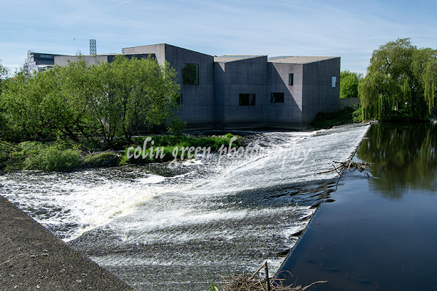
The Hepworth , Wakefield, Modern Art on the Banks of the Calder

The Hepworth Wakefield is a renowned art gallery in Wakefield, West Yorkshire, England. The building itself is a modern masterpiece, designed by the renowned architect David Chipperfield. The building is constructed of concrete and features large windows that offer stunning views of the River Calder, which flows alongside the gallery.

The Hepworth Wakefield is home to a significant collection of modern and contemporary art, including works by Barbara Hepworth, Henry Moore, and Damien Hirst. The gallery also hosts a variety of temporary exhibitions throughout the year.

The Hepworth Wakefield is a popular destination for art lovers from all over the world. The gallery is located in a scenic spot on the banks of the River Calder, and its beautiful architecture and stunning art collection make it a must-see for any visitor to Wakefield.

In addition to its permanent collection and temporary exhibitions, The Hepworth Wakefield also offers a variety of educational programmes and events. These programmes and events are designed to help visitors of all ages learn more about modern and contemporary art.

Whether you are an art lover or simply looking for a beautiful place to spend an afternoon, The Hepworth Wakefield is a great place to visit. The gallery is open Tuesday through Sunday from 10:00 AM to 5:00 PM.

The Hepworth opened in 2011 and is named after Barbara Hepworth, a modernist sculptor born in Wakefield in January 1910.

The pictures below were taken from the opposite side of the River Calder with a Nikon d3300, they were taken on the 11th May 2024. They can also be seen on Clickasnap and copies can be purchased on various products from my Zazzle stores.


Clicking either picture should open a link in another to the version on Clickasnap, I have a profile on Photo4me and stores on Zazzle where you can buy my images on various wall art and products, check them out via the links below, all open in another window.

All the images remain the copyright of Colin Green.


Saturday, 10 February 2024

Hawksclough Bridge, Mytholmroyd

Nestled amidst the rolling hills of the Calder Valley, in the charming Yorkshire village of Mytholmroyd, lies the Grade II listed Hawksclough Bridge. This seemingly unassuming structure, crafted from the warm embrace of local sandstone, is more than just a passage over the River Calder. It's a bridge woven with myth, whispered secrets, and the echoes of a bygone era.

As you stand upon its weathered stones, the gentle gurgle of the water below serenades you, transporting you back in time. Legend has it that the bridge was built by the devil himself, enticed by a wager with a local builder. The deal? The bridge's completion within a night was in exchange for the builder's soul. But as the rooster crowed, signalling the dawn, the bridge remained unfinished, just one stone short. The devil, cheated of his prize, vanished in a puff of brimstone, leaving behind the incomplete bridge as a testament to his trickery.

While the truth behind the bridge's construction is likely less fantastical, the myth adds a touch of magic to its history. It's a reminder that even the most ordinary structures can hold extraordinary stories, waiting to be unraveled by the curious mind.

But Hawksclough Bridge is more than just a relic of the past. It's a vibrant part of the Mytholmroyd community. Children clamber along its edges. Artists capture its rustic beauty in their paintings, and photographers find endless inspiration in its weathered nooks and crannies.

Below are a set of pictures taken at the bridge with a Nikon d3300 in July 2024.


Thanks for looking, please take a moment to share and follow me on social media, check out my stores on Zazzle and portfolio on Photo4Me via the links below.


All the pictures remain the copyright of Colin Green.

Friday, 22 September 2023

Mearclough Bridge and the River Calder

 Mearclough Bridge is a crossing over the River Calder at Sowerby Bridge, West Yorkshire, the current bridge is the latest of a few that have provided a river crossing here connecting the historic townships of Norland and Warley who were separated by the river. Norland town was responsible for keeping the bridge in good repair and were fined for failing in this on the previous bridge, that bridge was replaced by the current crossing between 1774 and the turn of the 19th century.

The current bridge is a 3 arch stone built structure which now has traffic restrictions to prevent HGV crossing it. These preventions were enacted when the new Sterne Mills Bridge was constructed in the mid 2010's, prior to this the only access to the industrial units and recycling centre nearby were via the bridge and it was hit and damaged a number of times by vehicles crossing as the bridge is barely wider than a single track road with no pedestrian pavements. It was given Grade II listed status in 1988 and carries Fall Lane over the River Calder.

From the bridge looking east towards Sowerby Bridge centre is Mearclough Weir which is thought to have once powered Mearclough Mills which is said to have been a Corn Mill around it's construction in the early 1800's.

The pictures below were taken on the 5th November 2016 with a Nikon d3300.

The River Calder pictured from Mearclough Bridge, the former mill weir seen in the middle of the picture. Mearclough Mills were a chemical site by the turn of the 20th century and occupied land on both sides of the river. The mills were known as Triangle Mills by the 1930's and involved in photographic printing.

The River Calder again pictured from the bridge looking in the direction of Copley, To the left of the picture hidden by the trees is the Calder and Hebble Navigation, to the right again hidden by trees is a tow path that runs alngside the river to Sterne Mills Bridge.

Mearclough Bridge, the tunnel area just beyond the right arch was once the cellar of a dwelling that occupied the top corner of the structure. The Calder and Hebble Navigation is behind the wall a few feet higher than the river, there is a water overflow for the canal into the river to the right of the picture not shown.

Mearclough Bridge has 3 arches, the 2 larger ones pictured cross the water, a third one crosses waste ground now and is hidden by the trees to the left.

Clicking any image should open a link in another window to the un-watermarked, higher resolution version on Clickasnap.

thenks for looking, please take a moment to share and follow me on social media.

All the pictures remain the copyright of Colin Green.

Saturday, 16 September 2023

River Calder at Copley - March 2015

 River Calder at Copley is a set of 6 pictures taken in March 2015 on an approx 1 mile stretch of the river from Copley Valley to the Village. The area around the river Calder at Copley Valley has seen major development since these pictures were taken, with new housing on the north bank of the river, new industrial units on the south side of the river, and a new bridge and roads linking the 2.

The majority of the site used to be covered by Sterne Mills, and the former Sowerby Bridge Sewage Works which had been opened in 1896. A mill had been on the site of Sterne Mills since at least the 18th century, but by the turn of the Millennium the site was unoccupied after the Standard Wire Company had moved away. The opposite banks of the river were originally a fording point until a wooden bridge was constructed, this was replaced by a single track concrete structure in 1914, and again by the current crossing a few years ago. The only remains of Sterne Mills today are the weir that powered the mill, and a sluice gate near the weir.

The pictures below were taken on the 8th March 2015 with a Polaroid is2132 camera, they can also be seen on Clickasnap, un-watermarked.

The former sluice gate is all that remains of the mills that once occupied the site.

The weir and modern bridge crossing, the 1914 bridge abutment can just be seen before the metal banking, behind the watermarked col.

The river passing Copley Village, the stone wall to the pictures left is all the remains of Edward Akroyd's Copley Mill which was demolished in 1974, the site is now covered by housing.

This picture was taken from the side of Copley Playing fields looking towards the bridge and wier.

Taken from the south bank, this path used to pass Sowerby Bridge Sewage Works, the site is now occupied by industrial units. I was told once that the river used to be navigable past this point until the canal came and weirs were built to power the mills.

The river again pictured here to the west of Sterne Mills Bridge, the north bank pictured across the river is now covered by housing on what was once considered a flood plain. Just about visible through the trees is the Halifax Bank's Copley Data Centre, opened in the mid 1980's the centre is earmarked for complete closure in 2025.

Clicking any image should open a link in another window to the un-watermarked, higher resolution version on Clickasnap.

Thanks for looking, please take a moment to share and follow me on social media.

All the pictures remain the copyright of Colin Green.

Monday, 1 May 2023

Sowerby Bridge Randoms

 Sowerby Bridge is a market town in Calderdale, West Yorkshire. Originally a crossing point over the River Calder the town grew fast during the industrial revolution on its proximity to the River's Calder and Ryburn that were used to power the textile and engineering mills that grew up around them. As time went on the Rivers were joined by firstly the Calder & Hebble Navigation Canal providing links to Wakefield and beyond, and then the Rochdale Canal with links to Lancashire and Manchester which helped to continue the growth of industry in the Sowerby Bridge area. The railways were next to arrive with Sowerby Bridge featuring a large goods yard at the modern location of Tesco and eventually becoming a railway junction town when the line opened up the Ryburn Valley.

The railway, canals, industries and town entered in to a period of decline after between the wars, that continued for many years after, with it's valley location making it difficult for modern industries to invest and many long standing companies withdrew from the town. In the 1980's the town marketed itself as a tourist destination with the town's annual Rushbearing parade, canoe slalom development and canal re-opening driving much of the regeneration.

The town remains a pleasant place to live, featuring in a number of TV shows in recent years including, Stay Lucky, Happy Valley and the English Game, although it is often overshadowed by it's near neighbours Halifax and Hebden Bridge.

The pictures below can also be seen on Clickasnap un-watermarked, they feature a number of well known locations around the town and were taken with a iPhone 11 on the 26th September 2021.

Rochdale Canal from Tower Hill Bridge

Co-op Bridge and steps, Hollins Mill Lane.

The Canal Basin

Christ Church, Tuel Lane Tunnel, Rochdale Canal and the Roxy

Railway Viaduct and Rivers Ryburn and Calder

Town Hall Clock from County Bridge. The building never served as the Town Hall despite it's name spending most of it's history as a bank.

Courtyard on the Old Cawsey, thought to be the amongst the oldest road's through Sowerby Bridge.

River Ryburn and Sowerby Bridge Swimming Pool.

Former Wesleyan Chapel at Bolton Brow.

Rochdale Canal from the Co-op bridge steps.

Jack O Th Locks at the entrance to Sowerby Bridge Canal Basin.

Old Cawsey Courtyard

River Calder and Canoe Slalom from County Bridge.

River Ryburn

Rochdale Canal from Co-Op Bridge

Lock 2 Sowerby Bridge Upper on the Rochdale Canal

River Calder from County Bridge

Co-Op Steps

Geese on the canal, the town has become locally known for geese running the rule of the town

The Rochdale Canal from Lock 2 towards Lock 1 and the canal basin.

Christ Church, Tuel Lane Tunnel and Christ Church from Lock 2 on the Rochdale Canal.

The Village Restaurant, formerly the Ash Tree pub.

Thanks for looking, please take a moment to share and follow me on social media.

All the pictures remain the copyright of Colin Green.

Through a Glass, Darkly: Hebden Bridge Railway Station in Negative

 There's something hauntingly beautiful about old photographs, especially when they're presented in a way that flips our perception....