Showing posts with label Viaduct. Show all posts

Saturday, 16 September 2023

Whitacre Mill Viaduct, Huddersfield

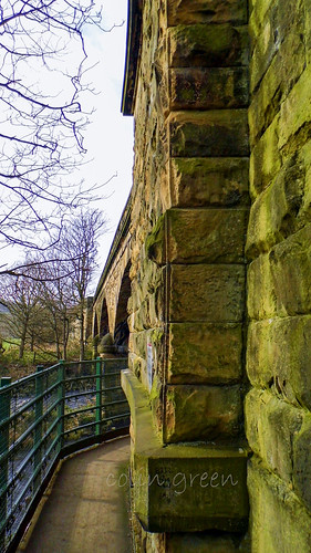
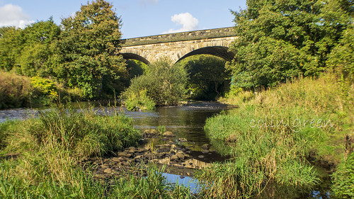
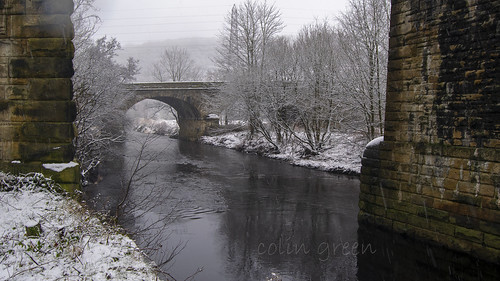
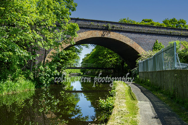
 Whitacre Mill Viaduct is a disused railway bridge crossing the Colne Valley at Deighton, Nr Huddersfield, built by the London & North Western Railway to carry the Kirkburton Branch Line, a 4 1/2 mile railway that had been intended to connect Huddersfield with the Barnsley coal mines, this scheme was never completed. Construction of the viaduct started in March 1865 by subcontractors Sigley, Miles and Haynes and the viaduct despite a partial collapse in February 1866 was completed prior to the lines opening on the 7th October 1867. The viaduct along with a short 1 mile section of the line from Deighton to ICI Chemical Works was the last to face closure, the majority having closed in 1965. This short section remained open until February 1971, before complete closure was decided in December that year.

The viaduct still crossers the Huddersfield Broad Canal, River Colne and Valley as a monument to a bygone age, it  can be just about accessed from the Deighton side, but is largely overgrown and impassable on the opposite side of the structure, Kirklees Council have plans to reopen the crossing as a greenway similar to the nearby Bradley Viaduct but as yet those plans have not progressed.

The pictures below were taken on the 27th May 2023 with a Nikon d3300.

The viaduct crossing the Huddersfield Broad Canal.

The top of the viaduct is supposed to be blocked off, I took this from the access point that has been removed. You can get approx 2/3 of the way across before the bushes become to thick to pass, walking along the top of the wall would have allowed me to get further but i'm not great with heights, so I thought better of that idea.

Huddersfield Broad Canal pictured from the viaduct, Longlands Lock number 4 is just visible at the top of the picture.

The Huddersfield Broad Canal from Whitacre Mill Viaduct. The picture was taken in the direction of Huddersfield.

The overgrown former trackbed looking towards the fence off access. The hole in the fence can be seen to the right of the picture if you follow the wall to the trees.


Clicking any image should open a link in another window to the higher resolution, un-watermarked version on Clickasnap.

Thanks for looking, please take a moment to share and follow me on social media.

All the pictures remain the copyright of Colin Green.

Monday, 2 May 2022

Copley Railway Viaduct (The Lesser Known One)

Copley Railway Viaduct, its official title being MVN2/160 or Copley Bottom Bridge is a railway crossing over the River Calder. The bridge is hidden away at the bottom end of Old Rishworthians Sports Ground and North Dean Woods to the east side of the village of Copley, West Yorkshire.

Opened in August 1840 by the Manchester and Leeds Railway the bridge once carried the main railway traffic through the Calder Valley until the nearby lines at Milner Royd and Greetland Junctions were built to carry rail traffic in the direction of Halifax. The line over the bridge was subject to closure plans during the late 1970's after the removal of Brighouse (Closed 1970) and Elland (closed 1962) Stations, but continued as a diversionary route for passenger trains and carried freight only traffic during this period. until the reopening of Brighouse Station in 2000 saw passenger traffic crossing the bridge regularly again. The open nature of the North Dean Side of the viaduct allows great opportunities to photograph the steam trains that pass over the bridge quite often, but if seeking out this chance please remember to always keep a safe distance away from the tracks, I normally stay well within the tree line.

These pictures were taken using a Nikon d3300 SLR on the 25 February 2019. They can also be seen full size, resolution and un-watermarked on Clickasnap.

The Copley side of the viaduct

Taken on the North Dean side of the bridge, looking in the
direction of Copley.

The bridge again taken from the North Dean side.

Taken from the far end of Old Rishworthians sports ground.

The top of the bridge, the open nature of the track at the bottom of North
Dean Woods allows great access for taking pictures of trains passing.
Please be aware of a safety when near the lines, this is level with the tree
line which i consider a safe distance from the track. although when
trains are approaching I stand much further back than this.

The River Calder flows underneath the bridge,

The River Calder, taken looking towards Copley from underneath
the viaduct.

Again in the direction of Copley but from the other side of the bridge.

Thanks for looking and please take a moment to share and follow me on social media.

All the pictures remain the copyright of Colin Green.

Saturday, 4 July 2020

Copley (Manchester and Leeds) Viaduct, the Small One.

The Manchester & Leeds Copley Viaduct is the lesser known, and the older of the 2 railway viaducts that cross the River Calder on the eastern end of the village of Copley, West Yorkshire.

Copley Railway Bridge

The 3 Arch Copley Viaduct lies a few metres south of the more widely known 23 arch Lancashire & Yorkshire Railway Viaduct and was opened in 1840, 12 years earlier than it's bigger brother. The viaduct was built by George Stephenson and given  Grade II listed status on the 19th July 1988.
The line that crossers over the bridge was closed to passengers in 1970 when Brighouse Station was closed, although officially this came in to effect on the 1st September 1986. Between 1970 and May 2000 the line was only used for goods transport and the occasional passenger service on diversion. During the 1980's plans to single track the line across the 23 arch viaduct and completely close the line across the 3 arch viaduct were discussed occasionally, whilst this would have made a fantastic walkway from Milner Royd Junction to Greetland, Elland and Brighouse, I am of the opinion that a railway line is of much better use.

The following video features the images and can be seen here and on YouTube. Please take a moment to subscribe to my channel.


Summer and the Calder at Copley Railway Bridge

Copley Railway Bridge Through the Pillars

Copley Railway Bridge Arch

Clicking any image should open a link in another window to my Clickasnap Railway Pictures album.

Thansk for looking, please take a moment to share and follow me on social media.

Sunday, 14 June 2020

The Ribblehead Viaduct.

Subscribe to my YouTube channel to see more videos like this.

My Ribblehead Viaduct collection is a set of 17 pictures, 1 which was taken in August 1976, the rest in April 2015. They can all be seen here, on Flickr, YouTube and on Clickasnap where they can also be downloaded.

The Ribblehead Viaduct or Batty Moss Viaduct is a 24 arch bridge that carries the Settle to Carlisle line across the Ribble Valley in North Yorkshire, England. Work began on the viaduct in 1869 or 70 according to different sources and ran until completion in August 1875. The workforce grew to approx. 2300 men who lived in camps with their families around the viaduct, these settlements were known as Batty Wife Hole, Sebastopol and Belgravia. The area around the base of the viaduct where these settlements were is now a scheduled ancient monument. Over 100 men died during the construction of Ribblehead Viaduct due to accident, fighting and an outbreak of smallpox. In addition to these men they were over 100 more deaths amongst the women and children of their families who lived in the camps. Many are buried in the nearby ST Leonards Church, Chapel-le-Dale where there is a plaque erected in the church in their memory.

The Midland Railway had planned a route through the area from the early 1860's and despite trying to withdraw from the planned line, which was rejected by parliament in April 1869 they commenced work in November 1869. By July 1870 the foundations were being constructed and the first stone was laid in October 1870. The plan had originally been for 18 arches but this changed in 1872 and it was decided 24 arches would be better for the design. Despite the change work continued at a good pace and by the end of 1874 the stone work was complete. The first goods train crossed the viaduct in August 1875, followed by the first passenger train in May 1876.

The viaduct is 400m long and 32m high at the highest point across the valley. The 24 arches have a span of approx. 14m and the foundations are 7.6m deep underground. It is the longest single structure on the Settle to Carlisle line and probably the most famous. There is the Ribblehead Railway Station approx. 1/2 mile south of the viaduct and the area is popular with walkers, there is also the Station Inn which offers accommodation, food and drink in the shadow of the Viaduct.

The story of the Ribblehead Viaduct may have ended if it wasn't for a plan by British Rail to close the line in the early 1980's. They argued that the high cost of repairing the viaduct and other structures along the route made the continued running of the line uneconomical. Between 1981 and 1984 over £100000 was spent on repairs to the viaduct and by the mid 1980's the track across had been reduced to single status with a 20mph speed limit. In November 1988 the Viaduct was given Grade II listed status and by this time a major campaign group had formed to fight the closure threat. Due to there campaigning and increased passenger numbers the line was saved from closure by 1989 and the viaduct underwent major repairs until 1991.

The majority pictures were taken on the 4th April 2015 with a Polaroid is2132 bridge camera. They can also be seen on Clickasnap un-watermarked where copies can also be purchased.


The viaduct is pictured in August 1976, note it is still double track not being singled until 1985 when it was once again subject to closure threats.


At no stage when taking these pictures did I ever enter within the fenced off areas of the track, and I would not recommend anyone else does either.

Thanks for looking, please take a moment to share and follow me on social media.

All the pictures remain the copyright of Colin Green.

Sunday, 26 April 2020

Denby Dale Railway Station and Viaduct

Denby Dale Railway Station serves the village of Denby Dale in Kirklees, West Yorkshire, it was opened on the 1st July 1850 as a much larger, grander station featuring a number of buildings and platforms and track in both directions. Much of the Penistone Line was singled north of Stocksmoor Station but the line past Denby Dale had already been reduced, having been singled from Clayton West Junction to Penistone through the station and over the viaduct in 1969, with the north bound platform, buildings and entrance removed, not much is evident they were ever there now.

The station was planned by the Huddersfield and Sheffield Junction Railway who had received permission from parliament to build the line in June 1845, by the time the build was completed and opened the line was owned by the Lancashire and Yorkshire Railway who they had merged with along with many others in July 1847.

The modern day station offers only limited facilities with no toilets or refreshments available, the village centre is only a short walk away though. It is currently used by an average of 3442 passengers per week with an hourly service in each direction Monday to Saturday. 

The pictures below, which can also be seen on Clickasnap were taken on the 21st May 2016 with a Nikon d3300 SLR camera.


The start of Denby Dale Viaduct is just visible down the track.


Denby Dale Viaduct was built along with the line and opened in 1850, originally it was constructed of timber, due to the local price of stone making the project unaffordable. Despite concerns and visit from the board of trade the timber viaduct remained until in March 1877, the railway company under heavy pressure from Huddersfield County Borough Council committed to building a new stone viaduct.  Work commenced on the new viaduct adjacent to the timber one in September 1877 and it was opened on the 15th May 1880. The viaduct is now Grade II listed and features 21 arches.


Thanks for looking, please take a moment to share and follow me on social media.

All the pictures remain the copyright of Colin Green.

Sunday, 17 June 2018

Tracing the Ghostly Rails: The North Dean Branch Line

Nestled in the heart of West Yorkshire, the remnants of a once-bustling railway line whisper tales of industrial heritage and bygone journeys. The North Dean, Stainland or Greetland and Stainland branch line, though short in length, played a vital role in connecting the mills of the valley to the wider world. Let's take a journey through its history and what remains today.

A Line Forged by Industry:

Opened on January 1st, 1875, this double-track line branched off the main line at Greetland, near Halifax, and climbed approximately 1.6 miles to its terminus at Stainland and Holywell Green Station. Its primary purpose was to serve the thriving textile mills that dotted the valley.

From Passengers to Goods:

For over half a century, the line carried passengers, with a surprisingly frequent service of 16 trains each way right up until its passenger closure on September 23rd, 1929. Goods traffic continued to rumble along the rails until September 14th, 1959, marking the final chapter for this industrious little line.

A Trail of Stations:

Despite its brief length, the line boasted four stations by 1907:

  • Greetland Station: The junction with the mainline, opened in 1844, and remained in operation until September 8th, 1962.
  • Rochdale Road Halt: Added in 1907 when rail motors were introduced, this passenger-only halt sat atop a bridge crossing the B6113 Rochdale Road at West Vale. Sadly, nothing remains of the bridge or the station today, having closed in 1929.
  • West Vale Station: Located just after the impressive West Vale Viaduct, only a partially covered retaining wall marks the station site within the Green Royd housing estate. It mirrored the lines opening and closing dates of 1875 and 1959.
  • Stainland and Holywell Green Station: The terminus of the line. Today, an industrial area occupies the site, leaving no trace of the station.

Architectural Echoes:

Two impressive viaducts stand as testaments to the engineering prowess of the era:

  • West Vale Viaduct: A Grade II listed, 13-arch structure, now a public footpath and cycleway, offering stunning views of West Vale.
  • Rawroyds (Stainland) Viaduct: Another Grade II listed marvel, this 14-arch viaduct spans the valley and Holywell Brook. While largely intact, it is now inaccessible, with only footpaths passing beneath its arches. The western embankment has been significantly altered for road access to Brookwoods Industrial Estate.

A Forgotten Path:

The line's final stretch passed under Long Heys Bridge, through a cutting beneath Station Road Bridge, and finally reached Stainland and Holywell Green Station. The cutting now serves as an access road.

A Photographic Glimpse:

These observations were captured with a Nikon d300 SLR camera on October 15th, 2017, providing a snapshot of the line's current state.

The North Dean branch line, though no longer active, leaves behind a fascinating legacy. Its viaducts, remnants of stations, and the stories they hold offer a glimpse into the industrial past of West Yorkshire.

Clicking any of the images below should open a link in another window to my Colin Green Photography store on Zazzle.


Clay House Bridge, Rochdale Road Halt was not far from here.


The previous 3 pictures were taken on the former track bed between what was the Rochdale Road Halt and West Vale Viaduct.


West Vale Viaduct, the above picture and 5 below show pictures taken from and of the viaduct.


West Vale viewed from the viaduct.


Long Heys Railway Bridge.


The cow was grazing in a field near top the railways former track bed. It seemed more interested in me than the field and other cows.


The 2 pictures show the remains of Rawroyds Viaduct, for a short branch line of less than 2 miles, this was the 2nd impressive viaduct that carried the line.


Thanks for looking, please take a moment to share and follow me on social media, and check out my portfolio's on Photo4Me and ClickAsnap via the links below.


All the pictures remain the copyright of Colin Green.

Through a Glass, Darkly: Hebden Bridge Railway Station in Negative

 There's something hauntingly beautiful about old photographs, especially when they're presented in a way that flips our perception....