Lumbutts Mill Water Tower. This Artwork created by is based on a picture I took. I gave the picture a sunset colour scheme as a nod to the areas links with the 1838 Mankinholes Riots to give the impression of a passion.
Thanks for looking, please take a moment to share and follow me on social media. The picture can also be seen on Clickasnap by clicking the image.
These pictures taken in March 2019 show various water based images taken around the Brighouse area. They were just randomly taken whilst out for a walk.
There are a total of 7 pictures which can be seen below and on Clickasnap full size, resolution and un-watermarked.
This small set of pictures was taken along the River Ryburn from Watson Mill Lane to its conclusion flowing into the River Calder just after the railway viaduct at Sowerby Bridge.
The River Ryburn starts in the hills above Baitings Reservoir and flows down the valley approx. 7 miles to its meeting with the River Calder, passing through or near Rishworth, Ripponden, Kebroys and Triangle. Along is route it is fed into by 12 tributaries and passes underneath 13 bridges.
These pictures were taken using a Samsung Galaxy Tablet in October 2013. They can be seen below and on Clickasnap where they are full size, resolution and un-watermarked.
The stone trough at the bottom of Stocks Lane, Luddenden was overgrown and largely forgotten about when I pictured it in October 2013. Trough's were spread around many villages, towns and cities before the coming of the motor vehicle to help water horses, dogs and even in some places cattle. Most have long since been removed or closed off no longer needed, but some can still be seen and a around a dozen still remain the Calderdale district.
The trough at the bottom of Stocks Lane is no longer fed with a large amount of water and most of the trough has been filled in with soil, bushes and plants. At the back is an inscription to William Patchett a local carpenter and undertaker, with the year 1861 and surveyor inscribed too. This was the year Patchett died, i don't know if the inscription is a memorial to him or a thanks to him for providing the trough.
These pictures were taken on the 13th October 2013 using a Samsung Galaxy Tablet. They can be seen below or on Clickasnap full size, resolution and un-watermarked.
Clicking any image should open a link in another window to the version on Clickasnap.
Thanks for looking and please take a moment to share and follow me on social media.
All the pictures remain the copyright of Colin Green.
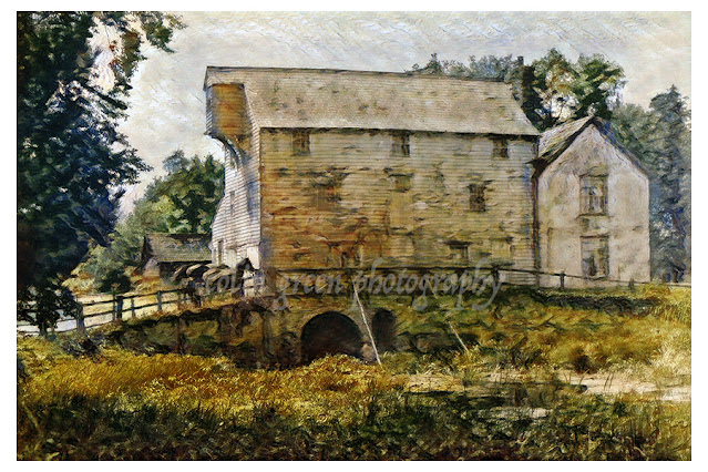
The watermill at Ixworth is an original digital artwork created by me based on an early 20th century black and white postcard. It shows a typical English rural scene of of a water powered flour mill with horses awaiting loads outside and a mill pond before the bridge.
The mill is thought to ave been built in the early 18th century and still stands today although no longer used as a flour mill. The building is 3 storeys and timber framed.
The picture can also be seen full size, resolution and un-watermarked on Clickasnap.
Thanks for looking and please take a moment to share. The artwork remains the copyright of Colin Green.
Hebden Bridge is a township in the Calder Valley made up of the townships of Erringden, Heptonstall, Stansfield and Wadsworth. The town is where the River Calder is joined by the Colden and Hebden waters, these waters helping to grow the town with the emergence of the cotton spinning industries. Originally the town was a fording point across Hebden Water, This was replaced by a packhorse bridge in 1510 and is how the town got its name. The Rochdale Canal arrived in the 1790's and the town was included in the new railway which opened in 1841.
Hebden Bridge's cotton spinning industries declined during the 1950's and 60's and the town became known as a hippy town during the 1970's when an influx of artists, writers, photographers, musicians, green, new age types moved in to the area converting many of the unused buildings in to squats. The town has in recent years become a popular tourist destination and become popular with people living there but commuting to work in the nearby cities of Leeds, Manchester and Sheffield.
The pictures below were taken on the 16 November 2013 using a Samsung Galaxy Tablet, they can also be seen on Clickasnap higher resolution and un-watermarked by clicking any image, link should open in another window.
The Rialto Bridge is the oldest crossing of the Grand Canal in Venice, Italy. One of 4 crossing points the bridge connects the districts of San Marco and San Polo. The current bridge made of stone began construction in 1588 and was completed in 1591, it is the last of several to have occupied this area of Venice and was built by Antonio da Ponte following a competition to design a new bridge.
The bridge is a major tourist attraction reachers a length of 31.8 metres (104.3ft), a height of 7.32 metres (24ft) and a width of 22.9 metres (75.1ft). There are 2 arcades of shops across the bridge separated by a central pathway of steps with another 2 paths to the rear of each row of shops. To support the bridge arch over 6000 timber piles were driven in to the soft embankments under each abutment.
The first bridge to cross the Grand Canal here was was the Ponte della Moneta, built as a pontoon bridge with ships fastened together and designed by Nicola Barattieri in 1181. This bridge was replaced in 1255 by a wooden construction because the nearby Realto market had grown considerably, this bridge had a movable platform in the middle to allow ships to pass. This bridge was the first to include shops who's taxes and rents helped with paying for the maintenance, it was during this time the bridge name was changed to Realto after the nearby market.
In 1310 the bridge was badly damaged by fire during the attempt to overthrow the Doge by Bajamonte Tiepolo and in 1444 it collapsed during the wedding celebration of the Marquis Ferrara. This led to the bridge being rebuilt as a drawbridge but once again in 1524 the bridge collapsed. In 1551 the authorities invited the most famous architects of the era to offer their ideas for a bridge, and in 1588 work started on the current bridge which was approved due to the design being of a single span arch. Many people doubted the bridge would last but so far it has stood for over 400 years and counting.
These pictures were taken on the 1st November 2018 using a Nikon d330 SLR camera, they can also be on Clickasnap by clicking any image, link will open in another window.
Thanks for looking and please take a moment to share and follow me on social media.
All the pictures remain the copyright of Colin Green.
Lumbutts is a small community in the hills to the southeast of Todmorden, West Yorkshire, the area grew around the mill which was used as a corn mill until leased by Brothers Samuel and Robert Shaw with there business partners Abraham Crossley and Thomas Hughes who converted the mill for use in cotton spinning. In the early 19th century the water tower was built to house firstly 2 waterwheels and eventually a third which when completed gave the mill over 50 horsepower created by the waters 90ft fall through the 3 wheels. The tower had supply from 4 dams which were Mill D~am, Lee Dam, Heeley Dam and finally Gaddings Dam which sits 365 meters above see level on the moor above Lumbutts.
The area was the scene of the Mankinholes riots in 1838 when the Poor Law Amendment Act 1834 led to a board of guardians making their first demand for £50 from the townsfolk which was refused. On November 14th, 16th and 21st 1838 riots broke out, and on November 24th a company of Dragoon Soldiers were despatched from Manchester to arrest all the men from Lumbutts Mill that had taken part in the riots.
The mill continued to provide employment until 1926, when the final 62 employees were either transferred or retired and Lumbutts Mill closed. The mill was demolished and only the Grade II listed water tower still remains. The site of the mill is now occupied by an activity centre.
Have you ever wondered about the imposing wall that lines a stretch of the Rochdale Canal in Todmorden? It's not just a simple retaining wall; it's a testament to the industrial might of the 19th century.
A Canal's Guardian
Constructed in 1881, this colossal structure was erected to support the expansion of Todmorden railway station's goods yard. Over 4 million bricks were used to build this engineering marvel, which stretches from near Lock 19 (known Todmorden and Library Lock) to Dobroyd Bridge (Bridge No. 30).
A Bygone Era
Before the advent of railways, the Rochdale Canal was a vital artery for transporting goods. However, as rail networks expanded, the canal's importance diminished. The construction of the wall was to expand the railway goods yard at Todmorden Station.
A Forgotten Legacy
Today, the goods yard has long been abandoned, and the land above the wall is now a peaceful woodland path. The wall itself, however, remains a striking reminder of the industrial past of Todmorden. Its imposing presence and intricate brickwork continue to captivate visitors.
Capturing the Wall's Grandeur
To truly appreciate the scale and beauty of this historic structure, check out these photographs captured on August 27, 2018.
By clicking on any image, you can view a higher-resolution version on Clickasnap.
So, the next time you're exploring the picturesque Rochdale Canal, take a moment to admire the mighty wall of Todmorden. It's a hidden gem that deserves to be recognized and appreciated.
The wall viewed from Dobroyd Bridge.
Dobroyd Bridge.
Todmorden Lock.
The following video features a slideshow of the 13 images that were originally posted and can be seen below and on YouTube.
Thanks for looking, please take a moment to share and follow me on social media. Clicking any image should open a link in another window to the un-watermarked, higher resolution version on Clickasnap.
Discover my world of art and photography on Zazzle and photo4Me! Explore my curated collections and find the perfect piece to bring your space to life. From Stunning wall art to unique merchandise, there's something for everyone, and with Zazzle's customisation options, you can personalise your favourite image to match your style and create a truly one of a kind piece.
Click any picture below to open a link to the store you require.
All the pictures remain the copyright of Colin Green.