Tuesday, 26 December 2017

Echoes of Industry: The Coal Drops of Sowerby Bridge

Nestled alongside the bustling Sowerby Bridge Railway Station, a silent testament to the town's industrial past stands in quiet decay: the Grade II listed coal drops. These fifteen imposing structures, part of a sweeping viaduct and embankment that stretches towards the enigmatic Dixon Scar Tunnel, paint a vivid picture of a bygone era, a time when coal fueled the heart of the region.

Built around 1875, just before the station's relocation to its current site, these coal drops were a vital artery in the town's economic life. Imagine the scene: steam locomotives chugging along the elevated tracks, their wagons laden with coal, ready to be unloaded into the waiting drops below. From here, the fuel would be distributed to homes and businesses across Sowerby Bridge, powering industries and warming hearths.

The very design of the drops speaks to their purpose. Each one, a sturdy brick and stone structure, was engineered to facilitate the efficient transfer of coal from railway wagon to ground level. The raised embankment, a marvel of Victorian engineering, allowed gravity to do much of the work, streamlining the delivery process. This system remained in active use until the 1970s, a testament to its effectiveness and the enduring reliance on coal.

However, time and changing energy landscapes have taken their toll. The coal drops, once a hive of activity, now stand largely abandoned. Though the yard below occasionally sees use by various companies, the structures themselves are left to weather the elements.

Their historical significance was recognized on July 19th, 1988, when they were granted Grade II listed status. This designation should have ensured their preservation, yet the reality has been one of gradual decay. The wooden components, visible in older photographs, have largely vanished, leaving gaping voids that speak to years of neglect.

For a time, there was a glimmer of hope. A plan emerged to breathe new life into these historic structures, envisioning the conversion of each drop into unique housing units. This ambitious project, promising a blend of industrial heritage and contemporary living, captured the imagination of many. However, over the years, the plan appears to have been shelved, leaving the future of the coal drops uncertain.

The story of the Sowerby Bridge coal drops is more than just a tale of architectural decay. It's a poignant reminder of the town's industrial roots, a tangible link to the generations who shaped the landscape we see today. As we walk past these silent sentinels, we are compelled to ask: what will become of them? Will they continue to fade into obscurity, or will a new vision emerge to restore their dignity and ensure their legacy for future generations?

The coal drops stand as a powerful symbol of a changing world. They whisper stories of innovation, industry, and the relentless march of progress. But they also raise important questions about preservation, adaptation, and the responsibility we bear to our industrial heritage. Perhaps, by remembering the past, we can find inspiration for the future, and find a way to give these remarkable structures a new purpose in the 21st century.

The first picture was taken with a Samsung Galaxy Tablet on the 20th October 2013. Clicking any image should open a link in another window to my Colin Green Photography store on Zazzle.


The following pictures were taken on the 6th April 2014 with a Polaroid is2132 bridge camera. They include some of the top part of the drops, I never accessed any of the wooden areas as I deemed them unsafe, they were removed a couple of years after taking the pictures.


Thanks for looking and please take a moment to share and follow me on social media and check out my portfolio on Photo4Me via the link below.


All the pictures remain the copyright of Colin Green.

Sunday, 24 December 2017

St. Paul's, Denholme: A Silent Sentinel Overlooking the Worth Valley

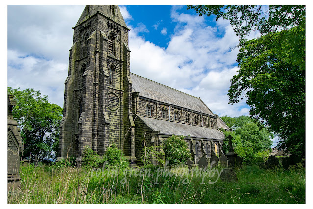
Nestled on a hillside overlooking the charming town of Denholme, West Yorkshire, stands the imposing yet melancholic shell of St. Paul's Church. A testament to Victorian ambition and a poignant reminder of shifting demographics, this Grade II listed building, consecrated in 1846, now exists in a state of quiet redundancy, its story etched in weathered stone and silent stained glass.

A Victorian Vision: Origins and Architecture

St. Paul's was erected during a period of rapid industrial expansion in the Worth Valley. Denholme, like many surrounding towns, experienced a surge in population, necessitating the construction of new places of worship. The church, designed in the Gothic Revival style, reflects the prevailing architectural tastes of the mid-19th century. Its construction speaks of the era's commitment to creating grand, spiritually uplifting structures.

Key architectural features that warrant attention include:

  • Materials: The church is constructed from locally sourced stone, a hallmark of Yorkshire architecture. This material not only provides durability but also lends a sense of continuity with the surrounding landscape.
  • Gothic Revival Elements: Observe the pointed arch windows, the intricate stone tracery, and the (now likely deteriorating) stained glass. These elements are quintessential to the Gothic Revival, a style that sought to evoke the grandeur of medieval cathedrals.
  • Tower and Spire: The church's tower, once a prominent landmark, likely featured a spire, which is a common feature in parish churches of this period. (If the spire is no longer present, this fact should be noted with possible reasons why.)
  • Plan and Layout: Research the original floor plan. Was it a traditional nave and chancel layout? Were there any notable features within the interior, such as a gallery, a specific type of pulpit, or particular stained glass windows? (This would be where online photos would be a great resource to cite.)

Decline and Redundancy: A Reflection of Changing Times

St. Paul's served its community for over 150 years, witnessing generations of baptisms, marriages, and funerals. However, by the late 20th century, the church faced dwindling congregations, a common trend in many rural areas.

  • The church's closure in June 1997, due to structural and safety concerns, marked a significant turning point. The final service within its walls was a poignant moment, signaling the end of an era.
  • The farewell service held in the new graveyard on September 5, 1999, further emphasized the church's redundancy, highlighting the community's shift towards alternative places of worship or changing religious practices.
  • The fact that the church became a private residence is a common solution for redundant churches. This shows the difficulty in maintaining such large structures.

Current Status: A Private Residence and Grounds

As noted, St. Paul's has since been converted into a private residence. This transformation presents a unique situation, blending historical preservation with contemporary living.

  • It is crucial to emphasize that there is no public access to the interior of the building. The current owners have a right to privacy, and any attempts to enter the property without permission would be a trespass.
  • While the grounds may be accessible for those wishing to visit loved ones buried in the graveyard, it is imperative to contact the owners beforehand to ascertain the current access policy. Do not assume that public access is granted.
  • The fact that the building has become a private residence, does give it a chance of survival, where otherwise it may have fallen into total disrepair.
 I took these pictures in July 2016 with a Nikon d3300 camera, clicking any image below should open a link in another window to my Colin Green Photography store on Zazzle.


Thanks for looking. please take a moment to share and follow me on social media and check out my portfolio on Photo4Me via the link below.


All the pictures remain the copyright of Colin Green.

Friday, 22 December 2017

Unveiling Halifax Minster.

While many know it simply as Halifax Minster, its full, resonant name, the Parish Church of St. John the Baptist, hints at a deeper story. Standing proudly as one of only three minsters within West Yorkshire, alongside its counterparts in Leeds and Dewsbury, Halifax Minster isn't just a building; it's a living chronicle of faith, community, and the ever-shifting tides of English history.

But what truly sets this minster apart? It's the palpable sense of time layered upon time, a tangible connection to centuries past. To say there's been a church on or near this site for over 900 years is a mere starting point. Imagine the countless prayers whispered, the hymns sung, the lives marked within these very walls.

Delving into the Depths of History:

The minster, as we see it today, reached its completed form around 1458, a testament to the dedication and craftsmanship of medieval artisans. But peel back the layers, and you'll find whispers of an earlier era. Fragments of the 12th century remain, like ancient echoes, reminding us of the Norman influence that shaped the early foundations. Over the centuries, the minster has been a canvas for successive generations, each leaving their mark through architectural additions and alterations. This organic growth, this evolution of form, is what makes Halifax Minster so compelling.

The Silent Witnesses: Stained Glass and the Puritan Shadow:

No exploration of Halifax Minster would be complete without considering its stained glass. These vibrant windows, once bursting with biblical narratives and devotional imagery, tell a story of both artistry and tumultuous change. The 17th century, a period of profound religious upheaval, saw the rise of the Puritan movement, which held significant sway in Halifax. The Puritans, with their emphasis on simplicity and their rejection of ornate religious displays, viewed stained glass as idolatrous. Consequently, many of these precious windows were removed, their radiant stories silenced.

However, the spirit of restoration has breathed new life into the minster. Where possible, these fragmented narratives have been pieced back together, a poignant reminder of the resilience of art and faith. The restored windows, though perhaps incomplete, offer glimpses into the rich iconography of the past, inviting us to contemplate the delicate balance between tradition and reform.

Beyond the Stones: The Minster's Role in Community:

Halifax Minster's story isn't confined to its architectural and artistic merits. It has always been, and continues to be, a vital hub for the community. Until November 2009, it served as a parish church, the heart of local spiritual life. The transition to minster status recognized its historical and regional significance, solidifying its role as a focal point for worship, reflection, and community engagement.

A Call to Exploration:

To truly appreciate Halifax Minster, one must experience it firsthand. Walk its hallowed aisles, trace the intricate stonework, and allow the stories embedded within its walls to resonate. Imagine the generations who have stood where you stand, their hopes and fears echoing through the centuries.

Halifax Minster isn't just a historical landmark; it's a living testament to the enduring power of faith, the resilience of art, and the enduring connection between a community and its spiritual heart. It's a place where the past and present converge, inviting us to explore, to reflect, and to discover the layers of history that make it so uniquely captivating.


The pictures were taken with a Polaroid is2132 Bridge Camera on the 1st June 2014, clicking any image below should open a link to my Colin Green Photography store on Zazzle.

Halifax Stocks, they can be seen outside the West Gate entrance to the church. They were moved from the north side of the gate to the south side in the 1960's


The West Gate, this used to be sighted further east near to the clock tower. It was moved to it's current location in the 1960's the former Halifax Stocks were also moved at the same time from the north side of the gate to the south side.


Thanks for looking and please take a moment to share and follow me on social media and check out my portfolio on Photo4Me via the link below.


All the pictures remain the copyright of Colin Green.

Saturday, 16 December 2017

The Queensbury Tunnel: A Victorian Titan's Struggle – Floods, Flaws, and a Fight for Future Life

Imagine a world powered by steam, where the roar of locomotives echoed through the Pennine hills, connecting bustling industrial towns. At the heart of this network lay the Queensbury Tunnel, a 2,287-meter (1.42-mile) subterranean artery, a testament to Victorian ambition and, tragically, a catalogue of engineering woes. This isn't just a disused railway tunnel; it's a saga etched in brick and water, a story of grand aspirations and the relentless forces of nature.

A Herculean Undertaking: The Tunnel's Birth Pangs

The story begins in 1874, a time of feverish railway expansion. The ambition was clear: to link Queensbury, perched high on the hills, with Holmfield, Halifax, and the wider industrial heartland of Bradford and Keighley. Construction was a monumental task, a relentless assault on the rugged terrain. For four long years, miners toiled, blasting and excavating, battling the stubborn bedrock.

July 1878 marked the official completion, a moment of triumph. Yet, even in its infancy, the tunnel harboured hidden flaws. While goods trains began their journeys in October, passenger services were delayed until December, a testament to lingering concerns about the quality of the work. The tunnel was deemed incomplete, a shadow of doubt cast over its structural integrity.

A Legacy of Flaws: The Tunnel's Troubled Life

The Queensbury Tunnel's operational history was a constant battle against its inherent weaknesses. Poor workmanship, a recurring theme in Victorian engineering projects, began to reveal itself. Cracks appeared in the arch and sidewalls, symptoms of shoddy construction. Subsidence, the gradual sinking of the ground, further exacerbated the problems. But the most relentless adversary was water.

Water ingress was a constant plague, seeping through the porous brickwork, weakening the structure. The Pennine hills, known for their abundant rainfall, proved an unrelenting source of moisture. The very landscape that the tunnel traversed became its greatest enemy.

And then, a critical blow. The infilling of the Strines cutting at the Halifax end, a seemingly innocuous act, transformed the tunnel into a giant, subterranean reservoir. The southern portal, once a gateway, became a floodgate. Water now surged into the tunnel, sometimes reaching halfway along its length, a chilling testament to the forces at play. This constant inundation accelerated the tunnel’s decay, turning it into a watery tomb.

The Department for Transport’s Decision and the Counter-Campaign

Today, the Department for Transport, the tunnel's current owner, views this waterlogged relic as a liability. The proposed infilling, the permanent sealing of the tunnel, is presented as a necessary measure to ensure public safety. Yet, this decision has ignited a passionate resistance.

The Queensbury Tunnel Society, a determined group of campaigners, sees a different future. They envision a vibrant cycling and walking route, a transformative asset for the community. They argue that the tunnel, despite its flaws, can be restored and repurposed.

Their vision is compelling: a lit, well-maintained tunnel, a safe and accessible path connecting communities. They point to the economic benefits, the health and wellbeing improvements, and the preservation of a vital piece of industrial heritage.

The Technical Challenges and the Spirit of Resilience

The challenges are undeniable. Restoring a waterlogged, structurally compromised tunnel is a daunting task. But the campaigners argue that with modern engineering techniques and a commitment to preservation, it can be done. They point to successful restoration projects elsewhere, proving that even the most challenging structures can be given a new lease on life.

The story of the Queensbury Tunnel is more than just a tale of bricks and mortar. It's a story of human ambition, the relentless forces of nature, and the enduring spirit of resilience. It's a story that asks us: what do we value? Do we abandon our past, or do we find ways to repurpose it for the future?

The pictures were taken with a Polaroid is2132 bridge camera on the 28th December 2014. Clicking any image below should open a link in another window to my Colin Green Photography store on Zazzle.

Brow Lane Bridge, used to carry the railway down from Queensbury in the direction of Keighley.

The gated northern Queensbury Tunnel portal.

Former trackbed looking towards the site of what was once Queensbury Railway Station.


The flooded southern portal and remains of Strines Cutting.


This former aqueduct used to carry Strines Beck over Strines cutting which ran approx 59ft below the beck. It now forms part of a flooded pool in the now infilled Strines Cutting.

Thanks for looking, please take a moment to share and follow me on social media and check out my portfolio on Photo4Me via the link below.


All the pictures remain the copyright of Colin Green.

Unearthing the Whispers of Donkey Bridge

Nestled within the verdant embrace of Maple Dean Clough, near Norland, West Yorkshire, lies a silent sentinel of a bygone era: Donkey Bridge. More than just a simple crossing, this unassuming structure whispers tales of packhorse trains, arduous journeys, and the enduring spirit of the Pennine landscape.

Finding Donkey Bridge is a treasure hunt in itself. It's a secret passage, a hidden gateway between Copley and Norland, demanding a touch of adventurous spirit. From Copley, the ascent along North Dean Road, culminating in a sharp hairpin bend, marks the trailhead. A woodland path, beckoning towards Norland, conceals the bridge's approach. Alternatively, from Norland, the journey begins at the end of Pickwood Lane, where a steep, cobbled path, often obscured by nature's exuberance, plunges down to the clough.

This cloak of secrecy is part of Donkey Bridge's charm. In summer, a verdant tapestry of overgrowth conceals its details, creating an almost mystical atmosphere. Winter, however, transforms the path into a slippery, icy challenge, a testament to the harsh realities faced by those who traversed it centuries ago.

But Donkey Bridge is more than just a picturesque obstacle. It's a tangible link to the past, a surviving fragment of an ancient packhorse route that connected the villages of Copley and Norland, and served as a vital artery to larger settlements beyond. These routes, predating modern roads, were the lifelines of the region, facilitating trade and communication across the rugged terrain.

Imagine the scene: sturdy packhorses, laden with goods, their hooves echoing on the cobbled path, their breath clouding in the crisp Pennine air. These were the workhorses of their time, carrying everything from wool and textiles to essential supplies. The bridge, a crucial point in their journey, allowed them to safely navigate the challenging terrain of Maple Dean Clough.

While the modern wooden planks of Donkey Bridge offer a safe passage today, it's the ancient stone supports that truly capture the imagination. These weathered sentinels, shrouded in a cloak of moss and vegetation, speak of centuries of resilience. Their robust construction, despite the relentless passage of time and the harsh elements, testifies to the skill and craftsmanship of those who built them.

Delving deeper into the history, one can imagine the evolution of this crossing. For generations, a bridge has spanned this clough, adapting to changing needs and materials. The original stone supports, likely hewn from local gritstone, would have formed the bedrock of the crossing. Over time, the wooden elements, susceptible to decay, would have been repeatedly replaced, each iteration reflecting the prevailing techniques and resources.

The overgrown nature of the site adds another layer of intrigue. It allows us to glimpse the bridge as it might have appeared in less manicured times, when nature held greater sway. The moss-covered stones and the encroaching vegetation create a sense of timelessness, a feeling of stepping back into a forgotten era.

Visiting Donkey Bridge is more than just a walk in the woods. It's an opportunity to connect with the past, to trace the footsteps of those who came before us, and to appreciate the enduring beauty of the Pennine landscape. It's a reminder that even in our fast-paced world, there are still hidden gems waiting to be discovered, whispers of history waiting to be heard.

To truly appreciate Donkey Bridge, consider:

  • Exploring the surrounding landscape: Take time to explore the wider Maple Dean Clough, imagining the lives of those who lived and worked in this area.
  • Researching packhorse routes: Learn more about the history of packhorse trails in the Pennines and their significance to the region's development.
  • Visiting other historical sites: Combine your visit to Donkey Bridge with other historical sites in the area, such as the nearby villages of Copley and Norland, to gain a deeper understanding of the region's past.
  • Taking photographs: Capture the beauty and atmosphere of Donkey Bridge and its surroundings, preserving a record of your journey.
  • Visiting at different times of the year: See how the bridge and its surroundings change with the seasons, from the lush greenery of summer to the stark beauty of winter.

Donkey Bridge is a testament to the enduring power of history and the beauty of the natural world. By taking the time to explore this hidden gem, we can gain a deeper appreciation for the rich tapestry of our past and the enduring spirit of the Pennine landscape.

The total of 6 pictures were taken on the 8th March 2014 using a Polaroid is2132 Bridge Camera. Clicking any image should open a link in another window to my Colin Green Photography store on Zazzle.


Thanks for looking and please take a moment to share and follow me on social media and check out my portfolio on Photo4Me via the link below.


All the pictures remain the copyright of Colin Green.

Tuesday, 12 December 2017

The Forgotten Bridge of Sowerby Bridge: Gas Works Road Bridge

Sowerby Bridge, a charming town nestled in the Calder Valley of West Yorkshire, boasts a rich industrial heritage. Among its many historical remnants, the Gas Works Road Bridge stands as a silent testament to a bygone era. Crossing the River Calder, this unassuming structure holds a story within its weathered stones, a story that deserves to be told and, more importantly, a story that demands action.

Built in 1816, the original bridge is a fascinating piece of engineering, the brainchild of Samuel Aydon and William Elwell. While much of their original design is now obscured by the widening that took place around 1850, its essence remains, a whisper of the past. Initially constructed for carriages, the bridge later accommodated the burgeoning automobile traffic of the 20th century. Imagine the clip-clop of horses' hooves giving way to the rumble of early motor cars traversing this very crossing.

Today, however, the Gas Works Road Bridge stands silent, a pedestrian-only pathway. While still open to foot traffic, its vehicular days are long gone. Local lore suggests the bridge was closed to cars sometime in the early 1980s due to structural weaknesses, although concrete evidence of this closure and its exact cause remains elusive. If anyone has information about this, please do share it in the comments below!

Despite its historical significance, the bridge appears to be slowly succumbing to the ravages of time. Granted Grade II listed status on July 19th, 1988, one would assume this designation would ensure its preservation. Sadly, this doesn't seem to be the case. The bridge continues to deteriorate, a victim of neglect. The local authority appears to have no clear plan for its restoration or even its long-term maintenance.

This is a tragedy. The Gas Works Road Bridge is more than just a crossing; it's a tangible link to Sowerby Bridge's past. It's a piece of our industrial heritage, a reminder of the ingenuity and craftsmanship of our ancestors. To allow it to crumble further would be a disservice to the community and a loss for future generations.

Clicking any of the images should open a link in another window to my Colin Green Photography store on Zazzle.

The first 2 pictures how the height of the river on Boxing Day 2015 when the River Calder flooded much of the Calder Valley.


The next 2 were taken at the bridge on the 30th July 2017 with a Nikon d3300SLR camera.


The next 6 were taken with a Polaroid is2132 bridge camera on the 22nd November 2014.


Thanks for looking and please take a moment to share and follow me on social media and check out my portfolio on Photo4Me via the link below.


All the pictures remain the copyright of Colin Green.

Through a Glass, Darkly: Hebden Bridge Railway Station in Negative

 There's something hauntingly beautiful about old photographs, especially when they're presented in a way that flips our perception....