Sunday, 31 December 2017

A Winter's Walk Through North Dean Woods

North Dean Woods, nestled on the fringes of Greetland within the Calderdale region, offer a captivating glimpse into the evolution of British woodland. Stretching from the meandering River Calder's valley floor to the elevated terrain beneath Norland, these woods are a living tapestry woven with centuries of ecological and human history. On a crisp December day in 2017, following a delicate snowfall of a few inches, I embarked on a journey through this enchanting landscape, capturing its serene beauty with my Nikon D3300. This blog post delves into the nuances of this walk, reflecting on the historical significance and natural beauty encountered along the way.

A Journey Through Time and Terrain:

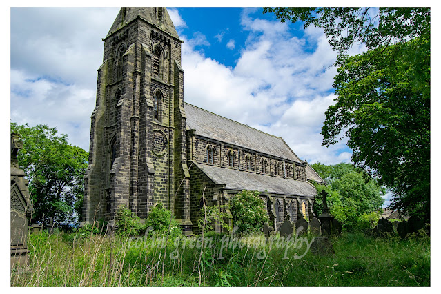
My exploration began at Wilson Bridge, a crossing point adjacent to the venerable St. Stephen's Church. This starting point itself speaks volumes about the intertwined relationship between community and nature in this region. The church, a silent sentinel, has witnessed the woods' transformation over generations.

The ascent through the woods along North Dean Road revealed the characteristic features of a typical British woodland. This landscape is a mosaic of deciduous trees, likely including oak, beech, and ash, reflecting the region's temperate climate and fertile soils. The recent snowfall accentuated the skeletal forms of these trees, highlighting their intricate branching patterns and the stark contrast between the white blanket and the dark, textured bark.

Ecological Insights:

North Dean Woods, like many similar woodlands, are a vital habitat for a diverse range of flora and fauna. The understory, though obscured by the snow, would typically host a variety of shrubs, ferns, and wildflowers, contributing to the woodland's biodiversity. The interplay of light and shadow, even under the overcast winter sky, reveals the complex ecological dynamics at play.

The proximity to the River Calder is a crucial factor in the woodland's ecosystem. The river's influence extends beyond its immediate banks, providing moisture and nutrients that support the surrounding vegetation. Furthermore, the river corridor acts as a vital pathway for wildlife, connecting fragmented habitats and facilitating species movement.

Historical Footprints:

The paths winding through North Dean Woods are not merely routes for recreational walkers; they are historical arteries that have connected communities for centuries. These pathways, often following ancient routes, reflect the human interaction with the landscape. The presence of features like Wilson Bridge and Donkey Bridge, near Pickwood Lane, hints at the historical significance of these routes for trade, travel, and local commerce.

The gradual transition from the valley floor to the higher elevations mirrors the historical land use patterns in the region. The lower slopes, closer to the river, would have been traditionally used for agriculture and grazing, while the higher elevations, more challenging to cultivate, would have remained predominantly woodland. This stratification of land use reflects the adaptive strategies of past communities in utilizing the available resources.

Winter's Silent Beauty:

The snowfall transformed the woods into a tranquil winter wonderland. The muffled sounds, the pristine white surfaces, and the delicate patterns created by the snow on the branches and leaves created a sense of serenity and isolation. The frozen landscape offered a unique perspective on the woodland's structure and form, revealing details that are often obscured by the lush foliage of summer.

The photographs captured on that day, serve as a visual record of this ephemeral beauty. They document the interplay of light and shadow, the textures of the bark and snow, and the overall atmosphere of the winter woodland.

Conclusion:

A walk through North Dean Woods is more than just a pleasant stroll; it's a journey through time and nature. The woodland's historical significance, ecological diversity, and serene beauty make it a valuable asset to the Calderdale region. The winter landscape, with its blanket of snow, offers a unique perspective on this timeless environment, revealing the enduring connection between humans and the natural world. These woods, like countless others across Britain, are a testament to the enduring legacy of our natural heritage.

The pictures were taken with a Nikon d3300 SLR camera on the 29th December 2017. Clicking any picture below should open a link in another window to my Colin Green Photography store on Zazzle.

Taken at the bottom of North Dean Road, I had just crossed the River Calder via
Wilson Bridge and passed St Stephens Church.


The copley valley and railway viaducts viewed from North Dean

This lane looks up towards Pickwood Scar, Norland. I'd not long since passed
over Donkey Bridge


Thanks for looking and please take a moment to share and follow me on social media, and check out my portfolio on Photo4Me via the link below.

All the images remain the copyright of Colin Green.

Saturday, 30 December 2017

Brockholes Railway Station: A History of Change and Resilience

Brockholes Railway Station, situated approximately four miles south of Huddersfield in West Yorkshire, serves the village of Brockholes on the scenic Penistone Line. Its story is one of expansion, decline, and eventual preservation, reflecting the broader trends in British railway history.

Early Development and the Holmfirth Branch:

  • 1850: A Vital Junction: The station opened on July 1, 1850, alongside the Penistone Line, built by the Lancashire and Yorkshire Railway. Critically, it also marked the inauguration of the Holmfirth Branch Line, transforming Brockholes into a significant junction. This strategic importance led to its temporary designation as "Brockholes Junction" during the 19th century.
  • Economic Significance: The railway's arrival spurred economic growth in Brockholes and the surrounding Holme Valley. It facilitated the transport of goods, particularly textiles from the local mills, and provided crucial passenger connections.

Decline and the Beeching Era:

  • Holmfirth Branch Closure (1959): The closure of the Holmfirth Branch Line in 1959 marked a significant turning point. This loss reduced the station's importance and foreshadowed future challenges.
  • The Beeching Axe (1963-1966): Dr. Richard Beeching's report in 1963 recommended the closure of numerous unprofitable railway lines and stations, including Brockholes. While the Ministry of Transport initially refused closure in April 1966, the cessation of goods traffic in 1965 led to the station's downgrading to an unmanned halt in August 1966. This transition reflected the shift from a full-service station to a basic passenger stop.
  • Demolition and Privatization (1970s): The decline continued with the demolition of some station buildings during the 1970s. The Station Master's house and offices on the "up" (Huddersfield-bound) platform were sold into private ownership, further reducing the station's operational footprint.

Survival and Preservation:

  • Threats of Closure (1980s): The threat of complete closure resurfaced in the 1980s, highlighting the ongoing financial pressures on the railway network.
  • Single-Line Operation (1989): In 1989, the double track was reduced to a single line, a common cost-saving measure on less busy routes. This resulted in the "down" (Sheffield-bound) platform becoming the sole operational platform.
  • Heritage Restoration: In more recent times, there has been a focus on preserving the station's heritage. The disused "up" platform and buildings have been restored, complete with period-appropriate signage, offering a glimpse into the station's past. This restoration is often done by local volunteer groups, who have great passion for the railway.
  • Current Usage: Despite its reduced infrastructure, Brockholes Railway Station remains a vital transport link for the local community. It handles approximately 60,000 passengers annually, demonstrating its continued importance. The station itself consists of a simple shelter on the active platform. Services are provided by Northern Trains.
  • Community Importance: The penistone line and its stations are very important to the communities they serve. The line is used by commuters, students, and leasure travellers. The line also gives access to rural areas.
The pictures below were taken on the 21st May 2016 with a Nikon d3300 SLR camera. Clicking any of the images below should open a link in another window to my Colin Green Photography store on Zazzle.


Thanks for looking, please take a moment to share and follow me on social media and check out my portfolio on Photo4Me via the link below.


All the pictures remain the copyright of Colin Green.

Thursday, 28 December 2017

Dunkeswell Methodist Church, Devon

The roar of engines faded into a gentle hum as I stepped away from the bustling Dunkeswell Aerodrome. My work there had afforded me an unexpected pocket of time, a rare moment to explore the surrounding countryside. With a map tucked into my pocket and a sense of wanderlust guiding my steps, I set off towards the village of Dunkeswell, a place whispered to be a haven of tranquility.

The approach to Dunkeswell was a sensory delight. Narrow lanes, bordered by ancient hedgerows bursting with wildflowers, wound their way through the rolling Devon landscape. The air, crisp and clean, carried the subtle scent of damp earth and blossoming honeysuckle. As I crested a gentle rise, the village revealed itself, a charming cluster of stone cottages nestled amidst verdant fields.

My aimless wander led me to a junction where Abbey Road met Manleys Lane. Perched on this slight elevation, commanding a gentle view of the village it served, stood Dunkeswell Methodist Church. It was a modest structure, its simple architecture speaking of a long history and a steadfast commitment to its community.

The church's exterior, constructed from local stone, bore the marks of time – a testament to the enduring spirit of the congregation. A small, well-maintained garden, brimming with vibrant blooms, softened the building's lines, inviting passers by to pause and reflect. The neat rows of pews visible through the windows hinted at the quiet gatherings held within, the shared hymns and whispered prayers that had filled this space for generations.

It wasn't the grandeur of a cathedral that struck me, but the intimate, almost familial atmosphere that radiated from the building. This wasn't a monument to power or wealth, but a humble sanctuary built on faith and community. One could easily imagine the generations of villagers who had sought solace and fellowship within its walls, their lives interwoven with the church's history.

The location itself, overlooking the village, seemed symbolic. It offered a vantage point, a place to step back from the everyday and contemplate the wider world. From this elevated position, the rhythms of village life unfolded – the distant sound of children playing, the gentle murmur of conversations, the reassuring presence of a community tied together by shared experience.

I paused for a moment, absorbing the peaceful atmosphere. The air was still, broken only by the occasional chirp of a bird. The quietude was profound, a welcome respite from the clamour of modern life. It was a reminder that amidst the constant flux of our world, there are still places where time seems to slow, where the simple act of being present can be a profound experience.

Dunkeswell Methodist Church, in its unassuming way, offered a glimpse into the heart of rural Devon – a place where faith and community are intertwined, where the beauty of simplicity is celebrated. It was a reminder that even in the smallest of villages, there are stories waiting to be discovered, moments of quiet reflection to be savoured. And for a brief moment, as I stood overlooking the village, I felt a sense of peace, a connection to the enduring spirit of Dunkeswell.

There pictures were taken on the 10th September 2105 with a Polaroid is2132 camera. Clicking any image below should open a link in another window to my Colin Green Photography store on Zazzle.

Thanks for looking and please take a moment to share and follow me on social media and check out my portfolio on Photo4Me via the link below.


All the pictures remain the copyright of Colin Green.

Tuesday, 26 December 2017

Ribblehead: A Station Reborn in the Shadow of Giants

The Yorkshire Dales, a landscape sculpted by time and nature, holds many hidden gems. One of the most captivating is Ribblehead Railway Station. Nestled a stone's throw from the iconic Ribblehead Viaduct, this station tells a story of resilience, restoration, and the enduring allure of the Settle to Carlisle line.

Imagine arriving at Ribblehead. The sheer scale of the viaduct, its 24 arches stretching across the valley, is breathtaking. But turn your gaze, and you'll find a station steeped in history, a testament to the railway's enduring impact on this remote corner of England.

Opened in 1876, Ribblehead was a vital stop on the Settle to Carlisle Railway, connecting communities and facilitating trade through the rugged terrain. For nearly a century, passengers alighted here, their journeys framed by the dramatic backdrop of the Dales. However, as with many rural stations, the rise of the motor car led to a decline in passenger numbers. In May 1970, Ribblehead Station closed its doors, seemingly consigned to history.

The station's fate seemed sealed. The north platform was demolished to make way for a transfer siding, and the southern platform succumbed to the relentless march of time, falling into disrepair. Yet, the story doesn't end there.

The Settle to Carlisle line, a feat of Victorian engineering, held a special place in the hearts of railway enthusiasts. In 1986, a glimmer of hope emerged when British Rail reopened the southbound platform to passenger traffic. This marked the beginning of Ribblehead's remarkable revival.

The momentum continued. In 1993, a brand-new northbound platform was constructed and opened, restoring the station's functionality. But the restoration didn't stop at the platforms. The station buildings, once derelict, were meticulously restored, a labour of love completed in 2000.

Today, Ribblehead Railway Station is operated by the dedicated volunteers of the Settle and Carlisle Trust. Their passion has breathed new life into this historic site, transforming it into a welcoming hub for visitors.

Stepping onto the platform, you can almost hear the echoes of the past, the steam whistles, and the bustle of Victorian travellers. The restored buildings offer a glimpse into the station's former glory, while the surrounding landscape remains as awe-inspiring as ever.

Whether you're a railway enthusiast, a history buff, or simply seeking a scenic escape, a visit to Ribblehead Railway Station is a must. It's a place where history and nature intertwine, a testament to the power of preservation, and a reminder of the enduring magic of the Settle to Carlisle line.

The pictures were taken on the 4th April 2015 with a Polaroid is2132 bridge camera. Clicking any image below should open a link in another window to my Colin Green Photography store on Zazzle.


Thanks for looking, please take a moment to share and follow me on social media and check out my portfolio on Photo4Me via the link below.


All the pictures remain the copyright of Colin Green.

Echoes of Industry: The Coal Drops of Sowerby Bridge

Nestled alongside the bustling Sowerby Bridge Railway Station, a silent testament to the town's industrial past stands in quiet decay: the Grade II listed coal drops. These fifteen imposing structures, part of a sweeping viaduct and embankment that stretches towards the enigmatic Dixon Scar Tunnel, paint a vivid picture of a bygone era, a time when coal fueled the heart of the region.

Built around 1875, just before the station's relocation to its current site, these coal drops were a vital artery in the town's economic life. Imagine the scene: steam locomotives chugging along the elevated tracks, their wagons laden with coal, ready to be unloaded into the waiting drops below. From here, the fuel would be distributed to homes and businesses across Sowerby Bridge, powering industries and warming hearths.

The very design of the drops speaks to their purpose. Each one, a sturdy brick and stone structure, was engineered to facilitate the efficient transfer of coal from railway wagon to ground level. The raised embankment, a marvel of Victorian engineering, allowed gravity to do much of the work, streamlining the delivery process. This system remained in active use until the 1970s, a testament to its effectiveness and the enduring reliance on coal.

However, time and changing energy landscapes have taken their toll. The coal drops, once a hive of activity, now stand largely abandoned. Though the yard below occasionally sees use by various companies, the structures themselves are left to weather the elements.

Their historical significance was recognized on July 19th, 1988, when they were granted Grade II listed status. This designation should have ensured their preservation, yet the reality has been one of gradual decay. The wooden components, visible in older photographs, have largely vanished, leaving gaping voids that speak to years of neglect.

For a time, there was a glimmer of hope. A plan emerged to breathe new life into these historic structures, envisioning the conversion of each drop into unique housing units. This ambitious project, promising a blend of industrial heritage and contemporary living, captured the imagination of many. However, over the years, the plan appears to have been shelved, leaving the future of the coal drops uncertain.

The story of the Sowerby Bridge coal drops is more than just a tale of architectural decay. It's a poignant reminder of the town's industrial roots, a tangible link to the generations who shaped the landscape we see today. As we walk past these silent sentinels, we are compelled to ask: what will become of them? Will they continue to fade into obscurity, or will a new vision emerge to restore their dignity and ensure their legacy for future generations?

The coal drops stand as a powerful symbol of a changing world. They whisper stories of innovation, industry, and the relentless march of progress. But they also raise important questions about preservation, adaptation, and the responsibility we bear to our industrial heritage. Perhaps, by remembering the past, we can find inspiration for the future, and find a way to give these remarkable structures a new purpose in the 21st century.

The first picture was taken with a Samsung Galaxy Tablet on the 20th October 2013. Clicking any image should open a link in another window to my Colin Green Photography store on Zazzle.


The following pictures were taken on the 6th April 2014 with a Polaroid is2132 bridge camera. They include some of the top part of the drops, I never accessed any of the wooden areas as I deemed them unsafe, they were removed a couple of years after taking the pictures.


Thanks for looking and please take a moment to share and follow me on social media and check out my portfolio on Photo4Me via the link below.


All the pictures remain the copyright of Colin Green.

Sunday, 24 December 2017

St. Paul's, Denholme: A Silent Sentinel Overlooking the Worth Valley

Nestled on a hillside overlooking the charming town of Denholme, West Yorkshire, stands the imposing yet melancholic shell of St. Paul's Church. A testament to Victorian ambition and a poignant reminder of shifting demographics, this Grade II listed building, consecrated in 1846, now exists in a state of quiet redundancy, its story etched in weathered stone and silent stained glass.

A Victorian Vision: Origins and Architecture

St. Paul's was erected during a period of rapid industrial expansion in the Worth Valley. Denholme, like many surrounding towns, experienced a surge in population, necessitating the construction of new places of worship. The church, designed in the Gothic Revival style, reflects the prevailing architectural tastes of the mid-19th century. Its construction speaks of the era's commitment to creating grand, spiritually uplifting structures.

Key architectural features that warrant attention include:

  • Materials: The church is constructed from locally sourced stone, a hallmark of Yorkshire architecture. This material not only provides durability but also lends a sense of continuity with the surrounding landscape.
  • Gothic Revival Elements: Observe the pointed arch windows, the intricate stone tracery, and the (now likely deteriorating) stained glass. These elements are quintessential to the Gothic Revival, a style that sought to evoke the grandeur of medieval cathedrals.
  • Tower and Spire: The church's tower, once a prominent landmark, likely featured a spire, which is a common feature in parish churches of this period. (If the spire is no longer present, this fact should be noted with possible reasons why.)
  • Plan and Layout: Research the original floor plan. Was it a traditional nave and chancel layout? Were there any notable features within the interior, such as a gallery, a specific type of pulpit, or particular stained glass windows? (This would be where online photos would be a great resource to cite.)

Decline and Redundancy: A Reflection of Changing Times

St. Paul's served its community for over 150 years, witnessing generations of baptisms, marriages, and funerals. However, by the late 20th century, the church faced dwindling congregations, a common trend in many rural areas.

  • The church's closure in June 1997, due to structural and safety concerns, marked a significant turning point. The final service within its walls was a poignant moment, signaling the end of an era.
  • The farewell service held in the new graveyard on September 5, 1999, further emphasized the church's redundancy, highlighting the community's shift towards alternative places of worship or changing religious practices.
  • The fact that the church became a private residence is a common solution for redundant churches. This shows the difficulty in maintaining such large structures.

Current Status: A Private Residence and Grounds

As noted, St. Paul's has since been converted into a private residence. This transformation presents a unique situation, blending historical preservation with contemporary living.

  • It is crucial to emphasize that there is no public access to the interior of the building. The current owners have a right to privacy, and any attempts to enter the property without permission would be a trespass.
  • While the grounds may be accessible for those wishing to visit loved ones buried in the graveyard, it is imperative to contact the owners beforehand to ascertain the current access policy. Do not assume that public access is granted.
  • The fact that the building has become a private residence, does give it a chance of survival, where otherwise it may have fallen into total disrepair.
 I took these pictures in July 2016 with a Nikon d3300 camera, clicking any image below should open a link in another window to my Colin Green Photography store on Zazzle.


Thanks for looking. please take a moment to share and follow me on social media and check out my portfolio on Photo4Me via the link below.


All the pictures remain the copyright of Colin Green.

Through a Glass, Darkly: Hebden Bridge Railway Station in Negative

 There's something hauntingly beautiful about old photographs, especially when they're presented in a way that flips our perception....