Carter Bar can be found on the A68 road at the top Redesdale Valley at a height of 1371ft above sea level. It is approx. 58 miles south east of Edinburgh, and 45 miles north west of Newcastle. The nearest town being Jedburgh.
Carter Bar has a viewing are which is popular with passes by who tend to stop and picture the stunning landscapes visible from the crossing. There are 2 large stones to mark the actual historic border between England and Scotland. The Cheviot Hills, Scottish Borders and Northumberland can be viewed for many miles and the crossings exposed placing and altitude means it can be quite cold on a summers day, and still snowy into late spring and early autumn.
On the 7th July 1575 Carter Bar was the scene of the last major battle between the Kingdoms of England and Scotland, this became known as the Raid of Redeswire. The area was also known to hold Truce Days, also known as March Law. This was a system of international law to settle cross border disputes between England and Scotland, attended by the Lord Warden of the Marches who was responsible for the security of the border regions. These became unnecessary after 1603 when the union of the crowns led to King James VI of Scotland being crowned King James I of England.
The full set of pictures can be seen below and on Clickasnap un-watermarked. They were taken with a Nikon d3300 SLR camera on the 24th October 2018.
Thanks for looking and please take a moment to share and follow me on social media.
All the pictures and video remain the copyright of Colin Green.
Subscribe to my YouTube channel to see more videos like this.
My Ribblehead Viaduct collection is a set of 17 pictures, 1 which was taken in August 1976, the rest in April 2015. They can all be seen here, on Flickr, YouTube and on Clickasnap where they can also be downloaded.
The Ribblehead Viaduct or Batty Moss Viaduct is a 24 arch bridge that carries the Settle to Carlisle line across the Ribble Valley in North Yorkshire, England. Work began on the viaduct in 1869 or 70 according to different sources and ran until completion in August 1875. The workforce grew to approx. 2300 men who lived in camps with their families around the viaduct, these settlements were known as Batty Wife Hole, Sebastopol and Belgravia. The area around the base of the viaduct where these settlements were is now a scheduled ancient monument. Over 100 men died during the construction of Ribblehead Viaduct due to accident, fighting and an outbreak of smallpox. In addition to these men they were over 100 more deaths amongst the women and children of their families who lived in the camps. Many are buried in the nearby ST Leonards Church, Chapel-le-Dale where there is a plaque erected in the church in their memory.
The Midland Railway had planned a route through the area from the early 1860's and despite trying to withdraw from the planned line, which was rejected by parliament in April 1869 they commenced work in November 1869. By July 1870 the foundations were being constructed and the first stone was laid in October 1870. The plan had originally been for 18 arches but this changed in 1872 and it was decided 24 arches would be better for the design. Despite the change work continued at a good pace and by the end of 1874 the stone work was complete. The first goods train crossed the viaduct in August 1875, followed by the first passenger train in May 1876.
The viaduct is 400m long and 32m high at the highest point across the valley. The 24 arches have a span of approx. 14m and the foundations are 7.6m deep underground. It is the longest single structure on the Settle to Carlisle line and probably the most famous. There is the Ribblehead Railway Station approx. 1/2 mile south of the viaduct and the area is popular with walkers, there is also the Station Inn which offers accommodation, food and drink in the shadow of the Viaduct.
The story of the Ribblehead Viaduct may have ended if it wasn't for a plan by British Rail to close the line in the early 1980's. They argued that the high cost of repairing the viaduct and other structures along the route made the continued running of the line uneconomical. Between 1981 and 1984 over £100000 was spent on repairs to the viaduct and by the mid 1980's the track across had been reduced to single status with a 20mph speed limit. In November 1988 the Viaduct was given Grade II listed status and by this time a major campaign group had formed to fight the closure threat. Due to there campaigning and increased passenger numbers the line was saved from closure by 1989 and the viaduct underwent major repairs until 1991.
The majority pictures were taken on the 4th April 2015 with a Polaroid is2132 bridge camera. They can also be seen on Clickasnap un-watermarked where copies can also be purchased.
The Parish Church of Kirkby Lonsdale, or by it's official name St Mary the Virgin is a Grade I listed Anglican place of worship overlooking the River Lune in the town of Kirkby Lonsdale, Cumbria.
Standing on it's current site since the 12th Century, with some of the architecture being of Norman build the church has many influences in it's build due to various rebuilds during it's history. In the 14th century the church was extended by rebuilding the north and south walls further out. further developments in the early 16th century included the addition of a new clerestory, pinnacles and battlements, these were removed during further refurbishments in 1807 as a new roof was added. Again the church was remodelled in 1866 by E.G Paley who once raised the roof, re-floored the chancel, added a south porch amongst many other developments.
In the grounds are a number of Grade II listed monuments and a 2 storey octagonal stone gazebo thought to date from the late 18th century. It was moved to it's current location to the north of St Mary's from the garden of the vicarage.
The pictures below were taken on the 4th April 2015 with a Polaroid is2132 camera. They can also be seen on Clickasnap un-watermarked and higher resolution. Click any image for a link to the Clickasnap version to open in another window.
Clicking any image should open a link in another window to the un-watermarked, higher resolution version on Clickasnap.
Thanks for looking, please take a moment to share and follow me on social media.
All the pictures remain the copyright of Colin Green.
Warley Moor is an area of open land approx. 6 miles north of Halifax on an old road route to Haworth, another 3 miles north of Warley Moor. The area lies just above the village of Wainstalls in an area known locally as Top Withins. The area is stunning and there have been many times I have been there and it seems to have it's own climate, it lies approx. 1440ft above sea level and I have known it sunny and calm when I have left my house down the valley at Sowerby Bridge and rainy and stormy when I have arrived at Warley Moor. The area is known locally by a number of different names, Them being Fly Flatts, Top Withins and Ovenden Moor.
As well as the outstanding moorland giving unbeatable views across the Calder, Hebble and Oxenhope Valleys, the moor is also home to Warley Moor Reservoir and Ovenden Moor Windfarm.
These pictures were taken on the 5th October 2013 using a Samsung Galaxy Tablet, they can be seen below or on Clickasnap full size, resolution and un-watermarked.
Warley Moor Reservoir
Completed in 1872 after a near 8 year build Warley Moor Reservoir or Fly Flatts as it is also known was built on behalf of the Halifax Waterworks Extension Scheme. When full it covers 68 acres, has a depth of 45 feet and holds approx. 193 million gallons. It is known owned and maintained by Yorkshire Water and the home of Halifax Sailing Club, established in 1959 the reservoirs high elevation makes them the highest sailing club in Britain.
Ovenden Moor Wind Farm
Opened in 1993 at a cost of £12 million, they site had 23 turbines when completed. Controversial when opened due to the turbines being in an area of outstanding natural beauty overlooking Bronte Country, and the Calder & Hebble Valleys the original turbines were expected to have a life span of 25 years and generate enough power for approx. 5500 homes. These were decommissioned in 2015 and replaced by 9 turbines with the power to generate more electricity, an estimated 11000 homes can now be powered from here.
The video below shows a number of pictures taken around the moor on a number of visits including this one on the 5ht October 2013.
Thanks for looking and please take a moment to share and follow me on social media. All the images can be purchased and viewed on Clickasnap.
All the pictures remain the copyright of Colin Green.
I have recently posted on a few occasions about the pictures I took of the pubs of Halifax Town Centre in May 2018, this is to be my final post of this collection and I have now included the video of the entire set of 32 pictures which I have uploaded to YouTube.
Please take a moment to view and subscribe to my YouTube Channel.
The Old Post Office The first Post Office in Halifax was sighted here in 1790, the pub was known as the Bowling Green until 2008 when it closed for a spell before re-opening in 2010 with it's current name.
The Royal Oak Rebuilt in 1929 using timber from HMS Newcastle the pub has had a number of different names in recent years including Tap & Spile and Dirty Dicks. It as here that Olive Smelt had been drinking on the 15th August 1975, the night she was attacked by the Yorkshire Ripper to become his 2nd victim. Happily she survived the attack and although she struggled to get over what happened that night lived to the age of 82.
The Westgate Originally built as an house it became a pub some time after 1843 when the owner John Oldfield Bates had died. Despite plans to refurbish the building and it's good central location near to the Piece Hall and Borough Market it has remained closed for several years now.
Union Cross Hotel The Oldest Inn in Halifax, it was renamed the Union Cross in 1745 to show support for the crown during the Jacobite Rebellion. Daniel Defoe and John Wesley have both stayed here, and like most old pubs within Halifax there is said to be tunnels from the cellars to the Parish Church. The building is Grade II listed. Webster's Brewery opened an in the adjoining Union Cross Yard.
The White Horse
Built in 1899 as a replacement for the earlier White Horse that opened in 1819 and stood nearby. The rebuilding was due to Southgate being widened.
Clicking any image should open a link in another window to my Clickasnap profile.
Thanks for looking, please take a moment to share and follow me on social media.
All the pictures remain the copyright of Colin Green.
Batch number 4 is another set of 6 pubs / clubs from the centre of Halifax, West Yorkshire. All were taken in May 2018 using a Nikon d3300 SLR camera.
Atik & Vinyl
Starting life in 1913 as the The Picture House until 1960, when it was closed for 2 years before becoming a bingo hall. Opened again as a cinema in 1973 it continued until closure in 1982. Again the building was unused for a few years before becoming the Coliseum Nightclub and Maine Street bar in 1987. In recent years it has been known as Liquid, Atik and Maine Street has become Vinyl. The building is Grade II listed.
Bar Rouge There are actually 3 different pubs/clubs housed in this building, Bar Rouge, Fusion and Panacea. Originally the site of the Globe public house the building was the head office of the Halifax Equitable Bank until it was taken over by Martins Bank in 1927. It then became a branch of Barclays Bank in 1969 until closure in 1985. In the early 1990's the building was converted at great cost by Mansfield Brewery in to the Coiners Bar. It has since had a number of names and owners and is currently up for sale.
Cat & Fiddle
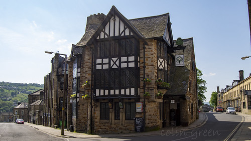
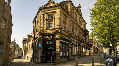
Originally the Golden Lion housed in the all white washed building next to Bon Marche, the pub extended in to the nearer building in 1987. It adopted it's popular nickname the Brass Cat in 1981 and has been known as the Cat & Fiddle in 2014. The Plummet Line
Built in 1897 as a replacement for the earlier Plummet Line Hotel which was to be demolished during the Bull Green redevelopment. Both were open alongside each other until 1898 as it is said there must always be a Plummet Line in this area of Halifax. I was once told that this was were Halifax RLFC's coaching team and senior players mapped out the tactics for their successful 1987 Challenge Cup run which resulted in Halifax beating St Helens 19-18 in the final at Wembley. Apparently the get togethers were known as the Monday night club.
Railway Hotel
The Railway is a former Ramsden Brewery pub within site of Halifax Railway Station. The hotel was the place where Janet Currie spent the night before drowning her child in the Calder & Hebble Navigation Canal. Despite people seeing her throw a bundle in to the canal, a child's body being found and being charged with the killing of a child on a couple of other occasions, the jury found her not guilty.
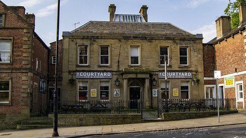
The Courtyard
Built in 1755 as Holly House it did not become a pub until the 1980's when it opened as Carrington's. It's most popular era was the 1990's through to early 2000's when it was known as the Bass House.
Clicking any image should open a link in another window to my Clickasnap profile.
Thanks for looking, please take a moment to follow me and share on social media.
All the pictures remain the copyright of Colin Green.