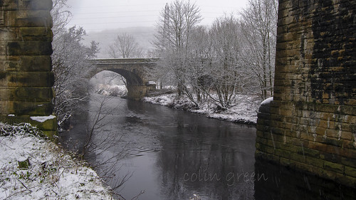
Lock 19 on the Rochdale Canal, Known as Todmorden or sometimes Library Lock can be found adjacent to Golden Lion Bridge Bridge number 30, Near the centre of Todmorden. The lock is a guillotine lock having had the eastern gates replaced due to their close proximity to the bridge. The first 3 pictures were taken yesterday 11 July 2020, with an additional one showing the view eastwards towards the guillotine lock and bridge taken on November 9th 2013.
The following picture is the November 2013 image of the lock, it was taken using a Samsung Galaxy tablet,
Clicking any image should open a link in another window to my Rochdale Canal pictures album on Clickasnap.
Thanks for looking and please take a moment to share and follow me on social media.
This latest post features a set of 6 vintage postcards that are approx. 80 - 90 years old, all are from the UK and unposted so it's hard to date them accurately.
The first one is of Flatford Bridge, and is a Judges LTD, Hastings card. The bridge is approx. 13 miles north east of Colchester, Essex and crossers the River Stour.
Guy's Cliff Bridge and Waterfall crossers the River Avon at Saxon Mill, Warwickshire. The card was published by W.A. Lenton of Leamington Spa.
North Gate, Totnes is a Grade II listed gateway in the Devonshire town. It was published by Valentine's as Sepiatype Series.
The fourth postcard in this set is of Bristol Cathedral.
Montgomery pictured from Kerry Road. The picture shows the town of Montgomery (English translation "the town of Baldwin"). The town is a border town in Powys, Wales.
The final postcard from this set is of the Temple Speech Room, Rugby. The card was published by Valentine's of Leamington Spa.
Clicking any image should open a link in another window to my Clickasnap profile.
Thanks for looking and please feel free to share. and follow me on social media.
Part of my large collection of Vintage postcards is this one I have of Glasgow Cathedral which is dated from the early 20th century, probably pre 1st world war. The company that produced the card was J.M & Co. LTD who were formed in 1903 in Edinburgh and it forms part of the companies Caledonian Series of cards. The card in my collection is unwritten and unposted.
Glasgow Cathedral is a Church of Scotland denomination place of worship that is also known by the names High Kirk of Glasgow, St Kentigern's and St Mungo's Cathedral. The Cathedral is built on the site where the Patron Saint Mungo is said to have built his church, and before the reformation was the seat of the Archbishop of Glasgow and a scene of Roman Catholic worship.
Clicking the image should open a link in another window to my Clickasnap profile.
Thanks for looking and please take a moment to share and follow me on social media.
Part of my collection of 35mm slides I have acquired over the years and am in the process of digitising. These were purchased by me a few years ago with the copyright assigned to me with the purchase. Sadly the collection was limited on information with only the place name and date sometimes provided. There are 5 I have uploaded today which can be seen here and on Flickr.
This picture was taken at the Brecon Beacons, Wales in July 1974.
The 2nd and 3rd pictures were both taken at the Farne Islands, Northumberland, England. They were taken just as people were gathering for a boat trip away or to the island I am not sure. The slides were pictured in July 1973.
The fourth images features a picture taken from height above Buttermere & Crommack Reservoirs in the Lake District. The date says it was taken in October 1978.
The final picture today was just titled Sussex Farm Dog. The picture was taken sometime in 1977 but no more information was added beyond the title.
Clicking any image should open a link in another window to my vintage images album on Clickasnap.
Thanks for looking and please take a moment to share and follow me on social media.
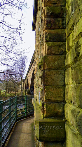
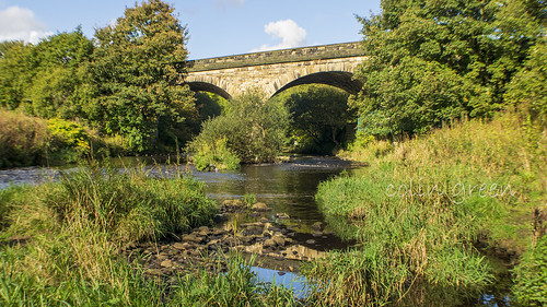
The Manchester & Leeds Copley Viaduct is the lesser known, and the older of the 2 railway viaducts that cross the River Calder on the eastern end of the village of Copley, West Yorkshire.
The 3 Arch Copley Viaduct lies a few metres south of the more widely known 23 arch Lancashire & Yorkshire Railway Viaduct and was opened in 1840, 12 years earlier than it's bigger brother. The viaduct was built by George Stephenson and given Grade II listed status on the 19th July 1988.
The line that crossers over the bridge was closed to passengers in 1970 when Brighouse Station was closed, although officially this came in to effect on the 1st September 1986. Between 1970 and May 2000 the line was only used for goods transport and the occasional passenger service on diversion. During the 1980's plans to single track the line across the 23 arch viaduct and completely close the line across the 3 arch viaduct were discussed occasionally, whilst this would have made a fantastic walkway from Milner Royd Junction to Greetland, Elland and Brighouse, I am of the opinion that a railway line is of much better use.
The following video features the images and can be seen here and on YouTube. Please take a moment to subscribe to my channel.
Clicking any image should open a link in another window to my Clickasnap Railway Pictures album.
Thansk for looking, please take a moment to share and follow me on social media.
A collection of pictures taken in North Yorkshire in 1975 - 1976. These are part of a set of 35mm slides I am currently digitising.
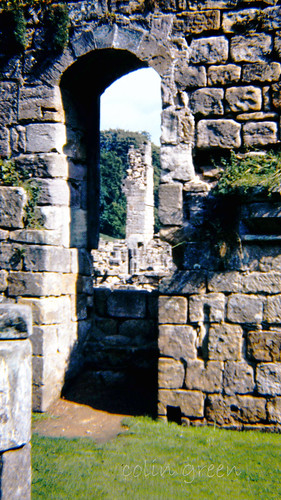
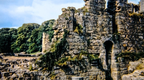
The first 3 pictures were taken at Fountains Abbey in September 1975. Fountains Abbey is a ruined Cistercian Monastery that operated from 1132 until it's dissolution under Henry VIII in 1539. They can be found a few short miles south-west of Ripon, North Yorkshire.
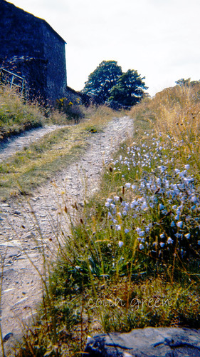
The following 2 pictures were taken around the small hamlet of Booze, North Yorkshire in August 1976. The area was built around farming and mining, with Chert, lead and slate all mined close by. Booze was devastated by a mining disaster in the late 18th century when 24 men and 2 ponies were drowned when they blasted in to an underground lake, 18 of the men were from Booze.
The final couple of pictures were taken in Langthwaite, North Yorkshire. It is one the most northerly settlements of the Yorkshire Dales National Park and is unusual in the area to have so many dwellings close together. These were taken in August 1976.
The final picture was taken in a garden at Grassington and shows a Amaryllis Plat in flower.
Thanks for looking and please take a moment to share. Clicking any image should open a link in another window to my Clickasnap vintage images album.
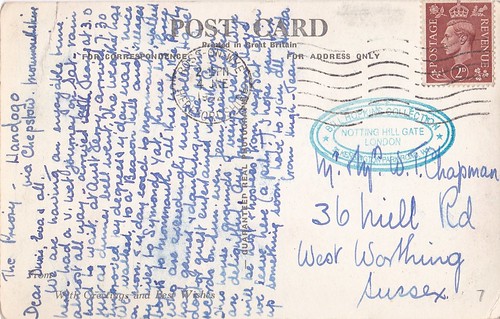
Here is another couple of pictures from my Large Postcard Collection. The first one was posted on the 4th June 1954 from Ross on Wye, Herefordshire to a Chapman, 36 Hill Road, West Worthing, Sussex. The picture shows the Priory, Llandogo, Monmouthshire, Wales. I am not sure the date is correct as the stamp is of King George VI who had died in 1952.
The postcard reads as best as I can as follows, if i can't make the word out I will just underscore
The Priory - Llandogo
Via Chepstow, Herefordshire.
Dear Denis, Eva and All,
We are having an enjoyable time here, had a v. wet journey on Saturday. Rain almost all the way. Arrived without Jerry at 3.00, had to wait at ____Jerry arrived 7.30 just as the dinner bell went the weather has been _______ __ ______ __ day was nice we walked to a beacon hill and villages ___ most of the rest of the card I unable to make out but it ends with, I hope you fix something up soon, love to you all ______Love from Hugh and Jerry.
The 2nd postcard I want to feature is of Happy Valley, Llandudno, these are a set of gardens that are home to wildlife animals and plants and still popular today. Llandudno Pier can also be seen in the picture.
Thanks for looking and please take a moment to share. Clicking either image should open a link in another window to my Clickasnap profile.
Part of my collection of Vintage Postcards is this one looking across the Happy Valley gardens, Llandudno, towards the town pier. The card was posted on the 11th August 1950.
Posted to a Mr & Mrs R. Acton
34 Worsley Road
Lower Walton
Warrington
Lancs.
The text as best I can make reads as follows,
Llandudno, Thurs
Having a very enjoyable holiday and regret it is nearly over. Weather has been mixed, but we have not been forced indoors. Had some lovely tours, and found N. Wales as beautiful as ever.
Love Helga & Harry
Thanks for looking and please take a moment to share. Clicking either image will open a link in another window to my Clickasnap profile.
Carter Bar can be found on the A68 road at the top Redesdale Valley at a height of 1371ft above sea level. It is approx. 58 miles south east of Edinburgh, and 45 miles north west of Newcastle. The nearest town being Jedburgh.
Carter Bar has a viewing are which is popular with passes by who tend to stop and picture the stunning landscapes visible from the crossing. There are 2 large stones to mark the actual historic border between England and Scotland. The Cheviot Hills, Scottish Borders and Northumberland can be viewed for many miles and the crossings exposed placing and altitude means it can be quite cold on a summers day, and still snowy into late spring and early autumn.
On the 7th July 1575 Carter Bar was the scene of the last major battle between the Kingdoms of England and Scotland, this became known as the Raid of Redeswire. The area was also known to hold Truce Days, also known as March Law. This was a system of international law to settle cross border disputes between England and Scotland, attended by the Lord Warden of the Marches who was responsible for the security of the border regions. These became unnecessary after 1603 when the union of the crowns led to King James VI of Scotland being crowned King James I of England.
The full set of pictures can be seen below and on Clickasnap un-watermarked. They were taken with a Nikon d3300 SLR camera on the 24th October 2018.
Thanks for looking and please take a moment to share and follow me on social media.
All the pictures and video remain the copyright of Colin Green.
Subscribe to my YouTube channel to see more videos like this.
My Ribblehead Viaduct collection is a set of 17 pictures, 1 which was taken in August 1976, the rest in April 2015. They can all be seen here, on Flickr, YouTube and on Clickasnap where they can also be downloaded.
The Ribblehead Viaduct or Batty Moss Viaduct is a 24 arch bridge that carries the Settle to Carlisle line across the Ribble Valley in North Yorkshire, England. Work began on the viaduct in 1869 or 70 according to different sources and ran until completion in August 1875. The workforce grew to approx. 2300 men who lived in camps with their families around the viaduct, these settlements were known as Batty Wife Hole, Sebastopol and Belgravia. The area around the base of the viaduct where these settlements were is now a scheduled ancient monument. Over 100 men died during the construction of Ribblehead Viaduct due to accident, fighting and an outbreak of smallpox. In addition to these men they were over 100 more deaths amongst the women and children of their families who lived in the camps. Many are buried in the nearby ST Leonards Church, Chapel-le-Dale where there is a plaque erected in the church in their memory.
The Midland Railway had planned a route through the area from the early 1860's and despite trying to withdraw from the planned line, which was rejected by parliament in April 1869 they commenced work in November 1869. By July 1870 the foundations were being constructed and the first stone was laid in October 1870. The plan had originally been for 18 arches but this changed in 1872 and it was decided 24 arches would be better for the design. Despite the change work continued at a good pace and by the end of 1874 the stone work was complete. The first goods train crossed the viaduct in August 1875, followed by the first passenger train in May 1876.
The viaduct is 400m long and 32m high at the highest point across the valley. The 24 arches have a span of approx. 14m and the foundations are 7.6m deep underground. It is the longest single structure on the Settle to Carlisle line and probably the most famous. There is the Ribblehead Railway Station approx. 1/2 mile south of the viaduct and the area is popular with walkers, there is also the Station Inn which offers accommodation, food and drink in the shadow of the Viaduct.
The story of the Ribblehead Viaduct may have ended if it wasn't for a plan by British Rail to close the line in the early 1980's. They argued that the high cost of repairing the viaduct and other structures along the route made the continued running of the line uneconomical. Between 1981 and 1984 over £100000 was spent on repairs to the viaduct and by the mid 1980's the track across had been reduced to single status with a 20mph speed limit. In November 1988 the Viaduct was given Grade II listed status and by this time a major campaign group had formed to fight the closure threat. Due to there campaigning and increased passenger numbers the line was saved from closure by 1989 and the viaduct underwent major repairs until 1991.
The majority pictures were taken on the 4th April 2015 with a Polaroid is2132 bridge camera. They can also be seen on Clickasnap un-watermarked where copies can also be purchased.