Saturday, 13 August 2022

Dewsbury Railway Station

 Dewsbury Railway Station is a station approx 9 miles south west of Leeds in West Yorkshire, England. The station provides trains with links to Leeds, Huddersfield, Manchester, York, Hull, Sowerby Bridge, Redcar and Hebden Bridge. In the last full year before the Covid pandemic (2019-20) the station served approx 1.622 million passengers at an average of 31,200 per week. The station is staffed during daytime hours and has self service ticket machines, it features waiting rooms on each platform which is connected by a footbridge which offers step free access via lifts. The station also features a pub on Platform 2 known as the West Riding Refreshment Rooms.

The station was opened on the 18th September 1848 by the London and North Western Railway who had taken over the lines builders the Leeds, Dewsbury and Manchester Railway. Dewsbury was to become something of a railway town for a time when there was 4 stations in the town in addition to a number in the nearby area. The stations serving the town were Dewsbury Central closed 1964, Dewsbury Market Place closed 1930, some of the stations facade can still be seen supporting the ring road, and Thornhill closed in 1961. From June 1924 until February 1969 Dewsbury Station was known as Dewsbury Wellington Road.

These pictures were taken in April 2015 using a Polaroid is2132 bridge camera. The 11 pictures can also be seen on Clickasnap full size, resolution and un-watermarked where copies can also be purchased.

The station's Milton Walk entrance.

The connecting bridge is also a public right of way connecting Milton Walk
with the town centre via the station.

Platform 1.

Platform 2.

The West Riding Refreshment Rooms.

The station pictured from Wellington Road Bridge.

The station pictured from Platform 1.

The bridge is a fantastically maintained gem.

Taken from the end of Platform 2's canopy.

The bridge and platform 2 pictured from platform 1.

The connecting bridge taken from above platform 2.

All the pictures can also be seen on Clickasnap. Please take a moment to share and follow me on social media.

All the images remain the copyright of Colin Green.

Sunday, 7 August 2022

Beggar's Bridge

 Beggars Bridge is a Grade II listed sandstone single arched bridge spanning about 48 feet across the River Esk, near Glaisdale Village, North Yorkshire. The bridge is thought to have been built in 1619 on the site of an earlier structure that had fell down, some of the stone taken from the earlier bridge.

The story of the bridge is that Thomas Ferris the man responsible for the construction had been born the son of a poor local farmer. Eventually he fell in love with the local squires daughter, who when approached for her hand in marriage refused believing Ferris to be a beggar.

After this rejection, Thomas decided to travel and make his fortune and upon trying to say goodbye to the squires daughter found the River had flooded and made crossing impossible. He left, and made his fortune and when he had returned married the squires daughter. He became the Sheriff of Hull from 1614 and Mayor in 1620, and had the bridge built in 1619 so that no future lovers shall be parted as he and his future wife had been.

The artwork below was created by me based on a postcard I had collected. Clicking the image should open a link in another window to my Clickasnap artworks album.

Thanks for looking and please take a moment to share and follow me on social media.

Saturday, 6 August 2022

Old School English Football Grounds.

 I recently completed a set of 4 artworks showing Griffin Park former home ground of Brentford FC based on some drone pictures I took around the stadium. I enjoyed creating the artworks and wanted to see if I could create some more based on old style English Football stadiums, I searched for a selection of images that were public domain and created the following artworks.

Due to the rules on Clickasnap I can not share the un-watermarked versions there, so if clicking any image below it will open a link in another window to my sports grounds artworks album on Clickasnap, all the images there are my own creation based on original photo's by me.

Newcastle United, St James Park
Home stadium on the Magpies, St James Park has seen much development
since it last looked like this in the Late 1980's

Reading FC, Elm Park
Opened in 1896 Elm Park was the home stadium of Reading until they moved
to the Madejski Stadium in 1998. Housing now occupies the site
of the stadium.

Brighton and Hove Albion, Goldstone Ground
Sold off in controversial circumstances the Goldstone Ground was
home to Brighton and Hove Albion from 1902 until 1997. The site is now
a retail park.

Chelsea FC, Stamford Bridge
Another stadium that is much changed since it looked like this in
the late 1980's. Originally opened by the London Athletic Club in 1877,
Stamford Bridge did not play host to Chelsea until the club was formed
in 1905. It is the only stadium they have played home games in to date.

Millwall FC, The Den
Now often known as the Old Den, Cold Blow Lane was the home ground of Millwall
from 1910 until 1993. The site is now occupied by housing.

Coventry City, Highfield Road
Home ground of Coventry City, Highfield Road was opened in 1899
and hosted it's final game on the 30th April 2005. Housing now occupies
the site of the stadium.

Oxford United, Manor Ground
Home stadium of Oxford United from 1925 until 2001, when the final match
saw Oxford draw 1-1 with Port Vale. The site is now occupied by the
Manor Hospital.

Manchester City, Maine Road
Home to City from 1923 until 11th May 2003 when the final match saw
Southampton win 1-0. The site was redeveloped in to housing after the
stadiums closure.

Arsenal, Highbury
The Arsenal Stadium was more commonly known as Highbury during it's
use as the home ground of Arsenal FC. Occupied by the Gunners from 1913
when the club moved from South London until 2006 when the stadium was
redeveloped in to housing.

Leicester City, Filbert Street
Opened in 1891 as the home ground of Leicester Fosse, it became the home ground
of the Foxes in 1919 when the club changed their name to City. It continued to be
the home stadium until 2003 when the club relocated to the Walkers Stadium, renamed
the King Power Stadium in 2011. Part of the site in now occupied by
student accommodation.

Thanks for looking and please take a moment to share and follow me on social media.

Wednesday, 27 July 2022

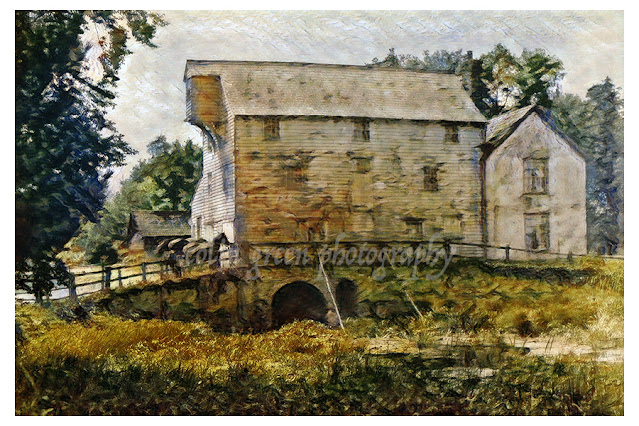
Watermill at Ixworth

 The watermill at Ixworth is an original digital artwork created by me based on an early 20th century black and white postcard. It shows a typical English rural scene of of a water powered flour mill with horses awaiting loads outside and a mill pond before the bridge.

The mill is thought to ave been built in the early 18th century and still stands today although no longer used as a flour mill. The building is 3 storeys and timber framed.

The picture can also be seen full size, resolution and un-watermarked on Clickasnap.

Thanks for looking and please take a moment to share. The artwork remains the copyright of Colin Green.

Sunday, 24 July 2022

Walsden To Todmorden along the Rochdale Canal. 14 November 2013

 The Rochdale Canal is a waterway in Northern England connecting Sowerby Bridge with Manchester. Built to move trade it opened in 1804, closed in 1952 falling largely in to disrepair and being blocked in a couple of locations before being restored and reopened fully in 2002.

The pictures below were taken on a walk of approx 1.5 miles from Walsden to Todmorden in November 2013, they were taken using a Samsung Galaxy Tablet. They can also be seen full size, resolution and un-watermarked on Clickasnap via the links below each.

Gauxholme Viaduct

Pinnel Lock


Smithyholm Lock

Walsden from the canal, St Peter's Church seen in the distance.

This stone chair was near Gauxholme Locks, no idea if it is still there.

All the links open in another window on Clickasnap, showing a full size, resolution and un-watermarked version of the picture. Please take a moment to share and follow me on social media.

All the images remain the copyright of Colin Green.

Saturday, 23 July 2022

Albert, Connel and Forth Bridges Artworks.

The major plus point to my job is that as a long distance lorry driver I get to see many parts of the United Kingdom I wouldn't get the chance to see. Because of this I get to photograph, sketch and create artworks of these places I visit. I recently set about creating a set of bridge pictures and the first 4 can now be seen below and on Clickasnap. They are based on pictures I have taken on my travels, in this case around Scotland and on 1 occasion to Northern Ireland.

There are 4 artworks to see below, they can also be seen full size, resolution and un-watermarked on Clickasnap. Copies can also be purchased if you require, just follow the link under each picture.

Connel Bridge, Oban, Scotland.


Built as a railway crossing over Loch Etive in Western Scotland, the Connel Bridge was opened in August 1903 by the Callander and Oban Railway to carry the Ballachulish Branch Line at a cost of £43000. In 1914 a roadway was added and the bridge was then used by both motor vehicles and rail traffic, however trains had priority and the roadway was closed whenever to vehicles whenever rail transport passed over. This continued until the railway was closed in the late 1960's. The bridge is still single track with traffic lights enforcing the right of way.

Connel Bridge is cantilever in design and has a span of 524 ft, it has a height restriction of 14ft. Near to the bridge are the Falls or Lora, because of the strong tidal flow caused by these the bridge was designed the way it was built. The A828 road runs across the bridge and Oban Airport is a little to the north.

The Forth Bridge


Opened in 1890, the Forth Bridge crossers the Firth of Forth to the east of Edinburgh, Scotland. It is often referred to as the Forth Rail Bridge, but its official name is the Forth Bridge due to it being the first crossing to be constructed connecting North and South Queensferry, the other 2 road crossing opening in 1964 and 2017. The Bridge is a UNESCO world Heritage site and probably the most famous man made construction in Scotland. It was designed by Sir John Fowler and Sir Benjamin Baker, with construction starting in 1882 and at its height involving over 4600 men employed in the building of it.

The Bridge was completed in December 1889, and after tests were completed was officially opened by the Duke of Rothesay on March 4 1890 when he drove home the final gold plated rivet.

Built in a cantilever design, it has a total length of 8094ft, a maximum width of 120ft at the piers, a height of 316ft, and allows a clearance of 150ft at high water mark for ships to pass underneath.

Albert Bridge, Belfast, Northern Ireland


The Albert Bridge was completed in 1890 and crossers the River Lagan near the centre of Belfast, Northern Ireland. Designed by JC Bretland to replace an earlier bridge that had collapsed in 1886, the bridge cost £36,500 (£5200000 in 2022 Value) to build and is named after Prince Albert Victor, the Grandson of Queen Victoria.

Thanks for looking and please take a moment to share and follow me on social media.

All the images remain the copyright of Colin Green.

Sunday, 17 July 2022

Ermita de Los Delores.

 Ermita de Los Delores is an 18th Century church in the village of Mancha Blanca on the Island of Lanzarote. The stunning little church was part of a tour of the island I took and has an interesting story or legend attached to it.

The last great volcanic eruptions to hit Lanzarote had lasted for 6 years when in April 1736, the villages of Mancha Blanca went with a priest carrying the Virgin Nuestra Senora de los Delores to meet the lava flow heading towards the village. When they reached Guigan they prayed and inserted a cross in to the ground, promising to build a church in the honour of the Virgin if she stopped the lava flow towards the village and fertile fields nearby.

The lava flow changed direction away from the villages and over a previous lava field, and the villages soon forgot their promise to build a church. In 1774 the Virgin appeared to a local shepherd girl and told her to remind the villagers they needed to construct the church, the girl was eventually believed and work started taking 10 years to complete the build of the church paid for by inhabitants from all over Lanzarote.

The church was closed in 1850 for restoration, reopening in 1861. It was again in need of restoration by 1988 and on the 18th June all the contents were removed to the Parish of Tinajo, including an image of the virgin. Just a few hours later the dome of the church collapsed.

I took 4 pictures of the church with a Samsung Galaxy Tablet, they can be seen here or on Clickasnap where they are full size, resolution and un-watermarked. They were taken on the 30th July 2013.


Clicking any image should open a link in another window to the Clickasnap Version.

Thanks for looking and please take a moment to share and follow me on social media.

All the pictures remain the copyright of Colin Green.

Sunday, 10 July 2022

A Snicket in Halifax 2022

 A Snicket in Halifax is a well known photo taken by Bill Brandt, a German born English photographer in 1937. The original picture which can be widely seen online shows a short cobbled hill climb from Old Lane, Dean Clough - North Bridge that led to a bridge across the then Queensbury Lines Railway and on towards Boothtown - Haley Hill. Whilst the railway has long since been removed the snicket and bridge still remain, the former line underneath being left to become overgrown with vegetation in recent years.

A snicket is commonly a phrase used in Northern England for a passageway between houses, garden's and fences. Also sometimes referred to as alley, ginnel, passage, path or alleyway.

The mill building shown in the background forms part of the Dean Clough complex and is known as Bowling Mill.

My copy which can be seen below or full size, resolution and un-watermarked on Clickasnap was taken on Sunday 3rd July 2022 using a Nikon d3300 SLR.

The original colour version I took of the picture can also be seen on Clickasnap and below,

Thanks for looking and please take a moment to share, all the pictures remain the copyright of Colin Green.

Saturday, 9 July 2022

Allan Park Art.

 Recently updating a set of images I posted in November 2016 of Allan Park, I found a set of 3 artworks I created of the park featuring the bowling green, a set of steps inside the park and a flower in bloom.

Allan Park is a public gardens and playground set in a woodland clinging to the Norland hillside. The park was once the grounds of Allan House which was purchased by the local council in 1922 and converted in to a public park. The park is something of a hidden gem being within a couple of minutes of the town centre and railway station, but never seemingly busy possibly due to its location on the other side of town from the major population centres. The park features a number of woodland walks, a playground and bowling green but no toilet or refreshment facilities, another reason it's probably quieter than most public park in Calderdale. Another feature of the park is the top of the Scar Head Tunnel entrance can be found by following one of the paths. The tunnel being part of the now closed Rishworth Branch Railway Line along the Ryburn Valley Bottom. Click here to see my November 2016 post featuring 11 pictures taken around the park.

The 3 artworks below are based on some featured in that set of photo's. They can be seen below or full size, resolution and un-watermarked only on Clickasnap.


Thanks for looking and please take a moment to share, all the images remain the copyright of Colin Green.

Friday, 1 July 2022

Ardrossan Beach (2013)

Ardrossan, a charming coastal town in Ayrshire, Scotland, boasts not one but two delightful beaches. Today's pictures were taken on Boydston Beach or North Shore.

Ardrossan North Beach stretchers out in a welcoming curve of golden sand, perfect for picnics, sandcastle building, and leisurely strolls. Feel the sand between your toes as you wander along the shoreline, letting the sound of the waves lull you into a relaxed state. For the more adventurous, the beach offers opportunities for paddling, swimming, and rockpooling in the cool waters of the Firth of Clyde. Remember to check the tides and weather conditions before heading into the water.

The true magic of Ardrossan North Beach unfolds when you turn your gaze outward. The beach offers stunning views across the Firth of Clyde, the majestic Isle of Arran, its peak visible on the horizon, and Horse Island, a nearby bird-watching sanctuary with its iconic 19th-century tower. On clear days, you might even catch a glimpse of the rolling hills of the Scottish Mainland to the north.

The beach is close to the town centre, allowing visitors to seek out the Victorian Promenade, and check out the town's rich maritime history by visiting the harbour. There are also a number of places to seek out refreshments nearby.

Ardrossan North Beach is a fantastic starting point for exploring the wider Ayrshire coast. Consider hopping on a ferry to the Isle of Arran for a day trip filled with natural beauty and historical intrigue.

For a dose of culture, head to the nearby town of Saltcoats and explore its art galleries and museums.

The pictures were taken with a Samsung Galaxy Tablet on the 28th November 2013.


Thanks for looking and please take a moment to share and follow me on social media.

Clicking any image should open a link in another window to the un-watermarked, higher resolution version on Clickasnap.

All the pictures remain the copyright of Colin Green.

Sunday, 26 June 2022

St Mary's Church, Whitby


Reached by climbing 199 steps and overlooking the harbour and town of Whitby, North Yorkshire, the Church of St Mary is a Grade I listed Anglican Parish Church. Founded on it's current site in 1110 in the shadow of Whitby Abbey, the current oldest parts of the church which include the tower and transepts date from the 12th and 13th centuries. There have been many additions and changes to the church and the interior dates mainly from the 18th Century.


The church forms part of the setting in the novel Dracula by Bram Stoker, he had visited Whitby in 1890 and was partly inspired by the town and graveyard at St Mary's, and whilst on a visit to the public library he came across the story of Vlad Tepes, the real life Dracula. In 1897 Stoker published his novel Dracula and the rest is history. People used to regularly search the graveyard for what they called Dracula's grave, in reality the novel is a work of fiction so no grave exists. Some graves used to have a skull and cross bones sculptured, which was thought to indicate it was the grave of a pirate although more likely a mason, 1 of these was the grave people searched for.  A former rector fed up at being asked the whereabouts of the grave at St Mary's used to direct people searching to a cracked tomb in the grounds its inscriptions weathered away long ago.

The pictures were taken in the grounds of St Mary's using a Nikon d3300 SLR on August 25 2018. There are 9 which can be seen here or on Clickasnap where they are full size, resolution and un-watermarked. Copies can also be downloaded from there.

The church stands besides the former Abbey overlooking the town.

Taken across the harbour from West Cliff.

Looking up from the harbour.


Thanks for looking and please take a moment to share and follow me on social media. Clicking any image should open a link in another window to the higher resolution, un-watermarked version of the image on Clickasnap.

All the pictures remain the copyright of Colin Green.


Through a Glass, Darkly: Hebden Bridge Railway Station in Negative

 There's something hauntingly beautiful about old photographs, especially when they're presented in a way that flips our perception....