Saturday, 3 September 2022

Cottingley Railway Station

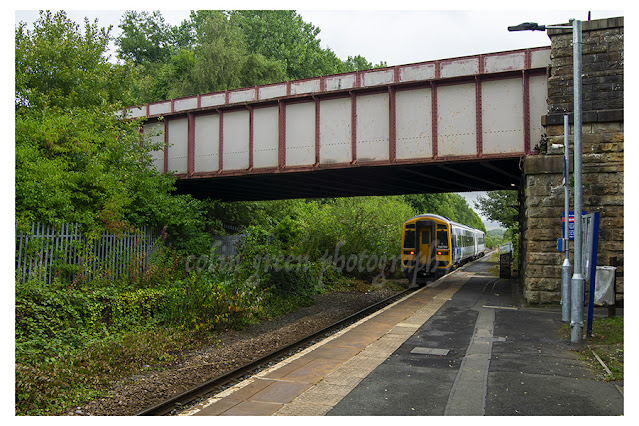
 Cottingley Railway Station is a 2 platform stop approx. 3 miles south west of Leeds, West Yorkshire, built to serve the communities of Churwell and Cottingley. Opened by West Yorkshire Passenger Transport Executive and British Rail on the 25th April 1988, the station is a basic facility offering limited shelter, car parking, facilities and access. Passenger use before the covid pandemic was steady at approx. 100000 per year, which is quite some growth on the average of 10000 per year in the early 2000's.


The station is intended to close in late 2022, early 2023 when the nearby White Rose Railway Station opens, the difference of just 1/2 a mile between the stations on the same Huddersfield Line makes keeping both unviable. The footbridge will remain after the station's closure.

These pictures were taken using a Nikon d3300 SLR camera on the 27th August 2022. They can be seen on Clickasnap where they are full size, resolution and un-watermarked.


Thanks for looking and please take a moment to share and follow me on social media, all the images can be seen on Clickasnap full size, resolution and un-watermarked. All the links open in another window.

All the images remain the copyright of Colin Green.

Monday, 29 August 2022

Lealholm Post Office and Service Station

Taken whilst exploring a section of the Esk Valley Railway, I'd just been to look at Lealholm Railway Station and walking back to the village centre I passed the post office and service station which to serve the village of Lealholm (Population approx. 380) and nearby rural villages and communities. I liked how what looked like a house had become probably a central part of the community.

The picture was taken using a Nikon d3300 SLR camera on the 27 August 2022, the artwork was completed on the 29 August 2022. Both can be seen and purchased on Clickasnap. I am currently working on a 2nd artwork to be completed shortly.


Thanks for looking and please take a moment to share and follow me on Social Media. The pictures can also be seen full size, resolution and un-watermarked on Clickasnap.

All the images remain the copyright of Colin Green.


Sunday, 21 August 2022

All Saints Church, Salterhebble

 All Saints Church is an Anglican place of worship in the Salterhebble area of Halifax, West Yorkshire and has the Parish of All Saints named after it. The foundation stone was laid on the 26th August 1857 and the church was designed by James Mallinson and Thomas Healey who designed several churches in the nearby area. Samuel Rhodes was a major benefactor in the construction of the church providing over 400 cart loads of stone from his own quarry for the building. The church opened in 1858 and has been in continuous use since.

These pictures were taken using a Polaroid is2132 bridge camera on the 24th October 2014, they can be seen below or on Clickasnap where they are full size, resolution and un-watermarked.


Thanks for looking and please take a moment to share and follow me on social media. The pictures can also be seen and purchased from my Clickasnap account.

All the images remain the copyright of Colin Green.

Saturday, 20 August 2022

Early Morning at Baitings Dam

Baitings Dam is a reservoir built to supply Wakefield with fresh water, completed in 1956 it is the higher of the 2 dams that block the flow of the River Ryburn here, the lower being Ryburn Dam. Construction cost around £1.4 million and took 8 years to complete, it involved flooding a small hamlet known as Baitings and sub merging the old packhorse bridge that provided a road link between Lancashire and Yorkshire, the bridge still stands and is revealed every time the water level is low. The bridge was replaced by a concrete structure called Back O'th Heights Bridge which gives a good indication of how high the dame is when full by the time marks just underneath the road level. When full the dam can hold over 113,000,000 cubic feet of water, or approx. 703,858,407 gallons.

Baitings is fed by runs offs from the local moorland and is the start of the River Ryburn that flows down the valley eventually reaching the River Calder at Sowerby Bridge approx 6 miles down the valley. It also flows in to the Ryburn Dam a little lower down the valley and built in 1933, also to supply water to Wakefield.

The pictures were taken around dawn on the 19th August 2022, whilst Baitings was at its lowest level for a couple of years. Despite being low and contrary to what local news outlets would have you believe this was not the first time in over 50 years the old bridge was visible, having been seen on at least 3 occasions in the last few years. It was once in a decade event but with the recent summer heat events being experienced in the UK this is becoming more regular.

The pictures were taken using a Nikon d3300 SLR and can also be seen on Clickasnap where they are full size, resolution and un-watermarked, copies can also be purchased there.


The tide marks underneath Back O'th Heights Bridge show the dams level when full.

The former bridge is submerged for most of the year, it's appearances becoming
more frequent in recent years.


The former bridge can be seen beyond it's replacement, this gives an idea of how low
the water level has dropped due to the recent dry weather.


The waterless back of the dam beyond the former bridge, the water level normally
hiding the river that feeds it.


I took this further up the A58 towards Rochdale, looking across the fields in the direction
of the bridges and Baitings Dam.

Thanks for looking and please take a moment to share. All the pictures can all be seen and purchased from Clickasnap, they are displayed full size, resolution and un-watermarked.

All the images remain the copyright of Colin Green.

Burnley Barracks Railway Station

 Burnley Barracks is a railway station on the East Lancashire Line. It is a request stop and offers a card only ticket machine and basic shelter as its only facilities. It has step free access but no car parking facilities other than on street parking. The station being only a request stop, 1 of 4 on the East Lancashire line is not a busy station although in the last full year of passenger figures 2020/21 attracted 9316, the previous 4 years averaging 21561 per annum, a drop in numbers of 12245.

The station became a request stop on the 14th May 2012, this means you have to inform the ticket inspector you would like to get off the train, or give a clear signal to the driver you would like to board. On the day I visited this was the busiest station of the 8 on the East Lancashire I visited with 3 passengers boarding and 2 alighting the train. The stations close location to both Rose Grove a few hundred metres east, and Burnley Central a few hundred metres west has Barracks earmarked for closure should the lines connection with Skipton and upgrade of the line come to fruition.

Colne bound training just leaving. It would 45 minutes before another train passed through the station.
There is 1 train in each direction approx. every hour.

Burnley Barracks opened on the 18th September 1848, it was the temporary terminus of the line yet to be completed to Colne and known as Burnley Westgate. In February 1849 the station was closed as the line was completed and there it's story was supposed to end, however development of the local area in to housing, industry and an army barracks led to Burnley Westgate reopening in September 1851, taking its name from the nearby cavalry barracks. The station opened as a 2 platform stop connected by a footbridge that dealt on the whole with just passengers, the nearby stations Rose Grove and Bank Top (Burnley Central) handling the goods traffic. The former eastbound platform remains although this is now largely overgrown and not visible, this was taken out of use when the line was singled beyond Rose Grove Station in 1986.

The army barracks closed in December 1898, and slum clearances of the local area in the 1960's and 70's led to declining passenger numbers, the construction of the nearby M65 motorway contributing to this too. The station has seen a steady rise of passenger use in recent years with new housing developments and peoples reluctance to use the car increasing.

There are a total of 5 pictures I took around the station, they can be seen here or on Clickasnap where they are full size, resolution and un-watermarked. Copies can be purchased there too if required.

The entrance sign to the station

The station looking west from the end of the platform. Despite Junction Street Bridge (Foreground)
and Padiham Road Bridge (Background) passing over the station, the 2 platforms were connected
by a wooden passenger bridge sighted between the 2. I assume this was removed when the line
was singled in the 1980's, but it may have been earlier as there is evidence on another site entrance
just off Junction Street Bridge.


The station looking eastward (towards Colne) from the end of the platform. The stations only
facilities are the shelter seen before the bridge and a ticket machine to my right
just out of shot.

Thanks for looking and please take a moment to share. All the pictures remain the copyright of Colin Green.

Friday, 19 August 2022

Sunrise at Baitings Dam (Single Shot)

Baitings Dam has featured in our local newspapers quite regularly during the recent hot weather, due to how low the water level has dropped. Reading some of them online, they have claimed that the bridge which can be seen in the foreground of the picture has been unveiled for the first time in over 50 years. This is incorrect, whilst it used to be perhaps a once in a decade event the water level dropping so low that the bridge appears, it is now every couple of years. I took a set around the bridge in September 2019 with the level similarly low in the dam, and I believe it has happened again since then.

Baitings Dam is a place I regularly walk my dogs and it was whilst out walking them a couple of days ago I thought i'd try and get up there early and picture the dam and bridges as the sun was rising. The following picture is the first of the set, the others to follow in a few days. The picture can also be seen on my Clickasnap account full size, resolution and un-watermarked.

The picture was taken using a Nikon d3300 SLR on the 19th August 2022.

The bridge in the foreground is the original packhorse bridge that crossed the River Ryburn before Baitings Dam was completed in 1956. Its replacement bridge Back O'th Heights seen behind, the water level at it's highest a couple of feet below it. The sun is rising in the distance with the dam head wall just visible beyond the higher bridge.

Thanks for looking and please take a moment to share. Copies can also be purchased from Clickasnap in addition to viewed full size, resolution and un-watermarked.

The picture remains the copyright of Colin Green.

Thursday, 18 August 2022

Jameos del Agua, Lanzarote.

 Jameos del Agua is a set of pictures I took in July 2013. This trip to Lanzarote was the first time i'd ever taken any sort of interest in photography as a hobby and that was due to having a Samsung Galaxy Tablet. At the time i thought the picture quality was fantastic, it's only by recently going through them and finding that out of over 30 pictures taken barely 10 are usable to show the area around Jameos del Agua.

The lobster sign at the entrance.

The Jameos del Agua attraction is a set of caves formed in the lava rock around the area. You can see a subterranean salt water lake which is home to a species of squat lobster, which are small, white and blind and can only be found at Jameos del Agua. It also features a restuarant, gardens, museum, auditorium and swimming pool. It is said that only the King of Spain is allowed to swim in the pool.

The attraction first opened to the public in 1966 and was the inspiration of Cesar Manrique, fully opening in 1977 including the auditorium which was closed for several years to the public.

These pictures were taken on the 30th July 2013 using a Samsung Galaxy Tablet, they can also be seen on my Clickasnap profile where they are full size, resolution and un-watermarked.

The swimming pool area, the guide I was with claimed that only the King
of Spain is allowed to swim here.

The stairs up from the saltwater cave to the swimming pool
and bar area.

The auditorium, the guide claimed gives one of the best sounds around.


The saltwater cave that is home to the squat lobster.

Thanks for looking and please take a moment to share and follow me on social media. You can also view and buy copies from my Clickasnap account.

All the pictures remain the copyright of Colin Green.

Wednesday, 17 August 2022

Operation Starfish, Dummy Aerodrome at Sowerby, West Yorkshire 16 August 2022

 I previously visited the remains of the Operation Starfish Site on the 15th June 2015 and posted about that visit in an earlier post. Whilst passing on the 16th August 2022 and now in possession of a much better camera I decided to visit the scene again. I knew nothing much would have changed and apart from a bit more rubbish being left, and a bit of damage to the brick work outside nothing really has changed.

The pictures below were taken using a Nikon d3300 SLR and can also be seen full size, resolution and un-watermarked on my Clickasnap account. The text below the pictures is taken from my post dated 3rd February 2018 featuring the images taken in 2015.


The blast door pictured in front of the bunkers main entrance

Inside the bunker on the left hand side of the entrance is this former control
room. Now filling up with rubbish that has been left behind.

Looking north over the bunker. In the foreground can be seen some
brickworks, probably housed washrooms and generators. Their isn't much
evidence of the site ever being linked to mains electric.


The former control room to the right hand side of the entrance.

Looking west away from the bunkers entrance, taken from the roof I
assume the site in front of me would have housed the metal pans
that created the dummy lighting effect.

The following text is taken from my previous post on the Operation Starfish plans.

Operation Starfish was a large scale 2nd World War decoy plan to fool German bombers in to dropping their payloads in the wrong areas. The plan was developed by Colonel John Turner after the near destruction of Coventry in November 1940. The sites were developed in the countryside approx. 4 miles from what were considered targets for the German bombers. The surrounding fields usually had a metal trough through the undergrowth which would be filled with a mixture of creosote, coal, diesel oil and set alight when bombers were in the area, after a short time of usually 15mins water would be added to create an explosion and a burst of flame fooling the overhead bombers in to thinking that it was the target after the initial bombs had dropped.

The site at Sowerby was developed as a decoy for the cities of Manchester and Leeds as well as the railway goods yards at, Greetland, Halifax, Todmorden, Littleborough and Rochdale. The site had a 2 room bunker which is still standing, which was entered through a short passage behind a blast wall.

Thanks for looking and please take a moment to share and follow me on social media.

All the pictures remain the copyright of Colin Green

Through a Glass, Darkly: Hebden Bridge Railway Station in Negative

 There's something hauntingly beautiful about old photographs, especially when they're presented in a way that flips our perception....