Saturday, 15 October 2022

Cova de Can Marca, Port de San Miguel, Ibiza.


The Cova de Can Marca is a former smugglers cave near Port de San Miguel, Northern Ibiza. The entrance steps give outstanding views across the bay and Mediterranean.

The cave is one of the most popular attractions on Ibiza, taking approx 40 mins to tour and offering a show of water light and sound in a natural environment. The tour also included a light show based around natural waterfall that was once a natural feature of the cave.

The pictures were taken using a Polaroid is2132 bridge camera on the 12th July 2014, they can be seen below and on Clickasnap full size, resolution and un-watermarked.

Entrance steps to the cave


Exit stairs from the caves.

Clicking any image should open a link in another window to the version on Clickasnap.

Thanks for looking, please take a moment to share and follow me on social media.

All the pictures remain the copyright of Colin Green.

Wednesday, 12 October 2022

Mytholmroyd Railway Station October 2013

 Mytholmroyd Railway Station was opened in May 1847 by the Manchester & Leeds Railway with temporary platforms and buildings, several years after the railway was completed through the Calder Valley. These temporary buildings were replaced by a new station with platforms overhanging Mytholmroyd Viaduct in December 1871 and thats how things remained for over 100 years. In the 1980's some of the buildings that overhung the viaduct were removed, in 1985 the station became an unstaffed stop, and by the decades end the Grade II listed former ticket office and entrance had been bordered up and closed, after new platforms were constructed to the eastern end of the station, the platforms overhanging the viaduct were also removed around this time.

Mytholmroyd Station has limited facilities including a small car park, bus shelter cover on each platform and electronic ticket machines. No refreshment or toilet facilities can be found at the station. In the last full years of passenger numbers the station was used by 45912 passengers. This was for the year 2020/21 during the covid pandemic and was an approx average of 882 per week, down from an average of 3884 per week pre covid.

These pictures were taken using a Samsung Galaxy Tablet on the 26th October 2013. They can be seen below or on Clickasnap full size, resolution and un-watermarked.


Thanks for looking and please take a moment to share and follow me on Social media.

All the pictures remain the copyright of Colin Green.

Sunday, 9 October 2022

A few Water Shots From Brighouse. March 2019

 These pictures taken in March 2019 show various water based images taken around the Brighouse area. They were just randomly taken whilst out for a walk.

There are a total of 7 pictures which can be seen below and on Clickasnap full size, resolution and un-watermarked.

The Calder & Hebble Navigation towards Ganny Foot Lock

The Calder & Hebble Navigation at Brookfoot bend.

Brookfoot Lock on the Calder & Hebble Navigation.

The M62 Motorway over the Calder & Hebble Navigation at Brighouse.

Calder & Hebble at Cromwell Bottom.

The junction of the Calder & Hebble Navigation and River Calder at Brighouse.

The River Calder at Brighouse.

Thanks for looking and please take a moment to follow me and share on social media.

All the pictures remain the copyright of Colin Green.

Saturday, 8 October 2022

Sowerby Bridge, Boxing Day Floods 2015

 The following pictures which I recently rediscovered were taken of high water levels around Sowerby Bridge during the Boxing Day 2015 flooding that devastated the Calder Valley. This was the worst flooding to hit Sowerby Bridge since the 1960's with millions of pounds in property damage along the route of devastation along the River Calder from Todmorden to Mirfield and beyond. Mytholmroyd and Hebden Bridge suffered a lot more than Sowerby Bridge with the floods but living in Sowerby Bridge it was easier to picture some of the water levels here.

These pictures were taken using a Polaroid is2132 bridge camera on the 26th December 2015. They can be seen below and on Clickasnap full size, resolution and un-watermarked. Copies can also be purchased their if required.

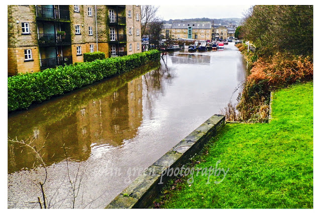
The flooded Calder & Hebble Navigation and Rochdale Canals from Chain Bridge.

The Calder & Hebble overflowing at Chain Bridge.

Rochdale Canal from Tower Hill Bridge. The towpath can normally be seen to the
right of the canal, the small wall probably prevented the car park and nearby town
centre from further damage.

Tuel Lane Lock gates flowing over.

The River Calder flowing past Kingfisher Chase towards Lockhart Mills. The levels is
normally 15 - 20ft lower than this.

The flooded Kirkham Turn. This is where the Rochdale canal joins the Calder &
Hebble Navigation.

Flooding at Tuel Lane Lock on the Rochdale Canal.

Very High River Calder flowing past the Weaving Shed Apartments (right of picture) and
Dugdales Mill left of picture. Dugdales was severely flooded during this event.

River Calder at Gas Works Bridge, considering the damage done to Cromwell, Copley and
Elland Bridges, I was surprised that Gas Works Bridge still stood after the floods.

River Calder at Gas Works Bridge, looking more like a dam head than river crossing.

High level River Calder at Lockhill Mill, much of the red brick building was damaged beyond
repair by the flood and demolished the year after.

River Calder from above the Turks Head Beer Garden, the lower half of the iron footbridge
was just in to the flooded area. Dugdales mill storage yard can be seen heavily
flooded in the background.

Thanks for looking and please take a moment to share and follow me on social media.

All the pictures remain the copyright of Colin Green.

Saturday, 1 October 2022

Dixie Tunnel and Woods, Sowerby Bridge 2013

 Dixie woods is a woodland that climbs from the Calder Valley in the direction of Sowerby Townships from Hollins Mills Lane, Sowerby Bridge, before ending alongside Sowerby Bridge Cemetery. It's proper given name is Dixon Scar Woods but most local people refer to it as Dixie Woods, towards the bottom of the woods flows the River Calder and it is home to Sowerby Bridge Cricket Club, a former cycle oval, football pitch and playing fields. The woodland has a number of footpaths, some leading in the direction of Sowerby, and others in the direction of Sowerby Bridge and one that follows alongside the river in the direction of Tenterfields.

Underneath the woodland runs Dixie Tunnel, its official name is Sowerby Tunnel, but is also referred to as Sowerby Tunnel and Long Tunnel. It was opened in 1840 and is approx. 657yds long leaving the industrial town setting of Sowerby Bridge at its eastern portal before emerging westerly in a rural environment.

The path that runs from Dixie Woods to Tenterfields. The River Calder seen on the left.

Dixie Woods looking in the direction of Sowerby Bridge from Friendly. The Rochdale Canal,
Ladstone and Houghton Towers all visible in the picture.

Dixie Woods pictured from Friendly, the Rochdale Canal running across the bottom.

Path through Dixie Woods away from the tunnel portal. The River Calder can be seen
at the valley bottom.

I've looked a number of times since I took this picture but never found this face again.

The following 2 pictures were taken at the western portal (Tenterfields) of the tunnel. On the day there were no trains running, I was with other people (safety in numbers), was in full railway safety gear, and had permission to be there. Please under no circumstances attempt to access a working railway line, even though lines of sight may give confidence you'll be safe, trains move fast and can approach unknowingly if attention is not being given.


These pictures were taken on various dates in 2013 using a Samsung Galaxy Tablet, they can also be seen un-watermarked, full size and resolution on Clickasnap by clicking the image.

Thanks for looking and please take a moment to share and follow me on social media.

All the pictures remain the copyright of Colin Green.

Sunday, 25 September 2022

River Ryburn at Sowerby Bridge October 2013

 This small set of pictures was taken along the River Ryburn from Watson Mill Lane to its conclusion flowing into the River Calder just after the railway viaduct at Sowerby Bridge.

The River Ryburn starts in the hills above Baitings Reservoir and flows down the valley approx. 7 miles to its meeting with the River Calder, passing through or near Rishworth, Ripponden, Kebroys and Triangle. Along is route it is fed into by 12 tributaries and passes underneath 13 bridges.

These pictures were taken using a Samsung Galaxy Tablet in October 2013. They can be seen below and on Clickasnap where they are full size, resolution and un-watermarked.

Geese and ducks in the River at Victoria Bridge

The Ryburn flowing in to the River Calder from underneath Sowerby Bridge railway viaduct, the former bridges bar can be seen on the right, as of September 2022 this is being demolished having stood empty for a number of years.


Thanks for looking and please take a moment to share and follow me on social media.

All the pictures remain the copyright of Colin Green.

Through a Glass, Darkly: Hebden Bridge Railway Station in Negative

 There's something hauntingly beautiful about old photographs, especially when they're presented in a way that flips our perception....