Sunday, 17 September 2023

Scenes from Ibiza's Northern Coast

 Below are a collection of images taken at various points along Ibiza's Northern Coast between Portinatx and San Miguel. They were taken whilst I was sailing between the 2 Villages for an approx distance of 4 nautical miles along the coast.

The pictures were taken using a Polaroid is2132 camera on the 12th July 2014.


Benirras Cove

Cala Benirras

Calo d'en Calders

Calo des Porcs

Cap Blanc

Punta de Llevant

Sa Polletta des Punset and entrance to Benirras

Sa Polletta des Punset

Illa des Bosc and the entrance to San Miguel cove.

Clicking any image should open a link in another window to the un-watermarked, higher resolution version on Clickasnap.

Thanks for looking, please take a moment to share and follow me on social media.

All the pictures remain the copyright of Colin Green.

Radical Steps, Kirkby Lonsdale.

 The Radical Steps at Kirkby Lonsdale are a set of stairs down from the area known as Ruskin's View, Nr St Mary's Churchyard to the banks of the River Lune. The steps are over 200 years old, they were built for Dr Francis Pearson in 1820 to divert a public footpath away from his land. He was said to be radical in his political thoughts, and because of this and local opposition to the reroute the steps became known as The Radical Steps.

The steps are quite steep and uneven in places, there are about 86 to navigate and are not suitable for disabled person's or people with walking difficulties.

The 4 pictures below were taken on the 4th April 2015 with a Polaroid is2132.

The wall that runs the length of the stairs means that quite often the steps can be damp and slippery even on dry days, the wall blocking sunlight and wind from drying the steps.


The River Lune is seen running along the bottom of the picture, the steps leading down to a path the runs alongside the river towards Devil's Bridge.

Clicking any image should open a link in another window to the un-watermarked, higher resolution version on Clickasnap.

Thanks for looking, please take a moment to share and follow me on social media.

All the pictures remain the copyright of Colin Green.

Saturday, 16 September 2023

Whitacre Mill Viaduct, Huddersfield

 Whitacre Mill Viaduct is a disused railway bridge crossing the Colne Valley at Deighton, Nr Huddersfield, built by the London & North Western Railway to carry the Kirkburton Branch Line, a 4 1/2 mile railway that had been intended to connect Huddersfield with the Barnsley coal mines, this scheme was never completed. Construction of the viaduct started in March 1865 by subcontractors Sigley, Miles and Haynes and the viaduct despite a partial collapse in February 1866 was completed prior to the lines opening on the 7th October 1867. The viaduct along with a short 1 mile section of the line from Deighton to ICI Chemical Works was the last to face closure, the majority having closed in 1965. This short section remained open until February 1971, before complete closure was decided in December that year.

The viaduct still crossers the Huddersfield Broad Canal, River Colne and Valley as a monument to a bygone age, it  can be just about accessed from the Deighton side, but is largely overgrown and impassable on the opposite side of the structure, Kirklees Council have plans to reopen the crossing as a greenway similar to the nearby Bradley Viaduct but as yet those plans have not progressed.

The pictures below were taken on the 27th May 2023 with a Nikon d3300.

The viaduct crossing the Huddersfield Broad Canal.

The top of the viaduct is supposed to be blocked off, I took this from the access point that has been removed. You can get approx 2/3 of the way across before the bushes become to thick to pass, walking along the top of the wall would have allowed me to get further but i'm not great with heights, so I thought better of that idea.

Huddersfield Broad Canal pictured from the viaduct, Longlands Lock number 4 is just visible at the top of the picture.

The Huddersfield Broad Canal from Whitacre Mill Viaduct. The picture was taken in the direction of Huddersfield.

The overgrown former trackbed looking towards the fence off access. The hole in the fence can be seen to the right of the picture if you follow the wall to the trees.


Clicking any image should open a link in another window to the higher resolution, un-watermarked version on Clickasnap.

Thanks for looking, please take a moment to share and follow me on social media.

All the pictures remain the copyright of Colin Green.

River Calder at Copley - March 2015

 River Calder at Copley is a set of 6 pictures taken in March 2015 on an approx 1 mile stretch of the river from Copley Valley to the Village. The area around the river Calder at Copley Valley has seen major development since these pictures were taken, with new housing on the north bank of the river, new industrial units on the south side of the river, and a new bridge and roads linking the 2.

The majority of the site used to be covered by Sterne Mills, and the former Sowerby Bridge Sewage Works which had been opened in 1896. A mill had been on the site of Sterne Mills since at least the 18th century, but by the turn of the Millennium the site was unoccupied after the Standard Wire Company had moved away. The opposite banks of the river were originally a fording point until a wooden bridge was constructed, this was replaced by a single track concrete structure in 1914, and again by the current crossing a few years ago. The only remains of Sterne Mills today are the weir that powered the mill, and a sluice gate near the weir.

The pictures below were taken on the 8th March 2015 with a Polaroid is2132 camera, they can also be seen on Clickasnap, un-watermarked.

The former sluice gate is all that remains of the mills that once occupied the site.

The weir and modern bridge crossing, the 1914 bridge abutment can just be seen before the metal banking, behind the watermarked col.

The river passing Copley Village, the stone wall to the pictures left is all the remains of Edward Akroyd's Copley Mill which was demolished in 1974, the site is now covered by housing.

This picture was taken from the side of Copley Playing fields looking towards the bridge and wier.

Taken from the south bank, this path used to pass Sowerby Bridge Sewage Works, the site is now occupied by industrial units. I was told once that the river used to be navigable past this point until the canal came and weirs were built to power the mills.

The river again pictured here to the west of Sterne Mills Bridge, the north bank pictured across the river is now covered by housing on what was once considered a flood plain. Just about visible through the trees is the Halifax Bank's Copley Data Centre, opened in the mid 1980's the centre is earmarked for complete closure in 2025.

Clicking any image should open a link in another window to the un-watermarked, higher resolution version on Clickasnap.

Thanks for looking, please take a moment to share and follow me on social media.

All the pictures remain the copyright of Colin Green.

Friday, 15 September 2023

Todmorden Town Hall (2013)

Todmorden Town Hall is a neo-classical Grade I listed building. Building work commenced in 1860 and the hall went through many changes with architect James Green being the original designer, work stopped in the 1860's due to legal and financial problems, before the Fielden family purchased the land and hall in January 1866 at auction. John Gibson of Westminster was then appointed to redesign the building which was completed and opened on 3rd April 1875 at a cost of £54,000.

The building was built across the Lancashire - Yorkshire county boundary to help unite the rivalries, although this boundary was moved on the 1st January 1888, bringing the hall and the town of Todmorden within the Yorkshire county fully.

The pictures below were taken on the 28th November 2013 with a Samsung Galaxy Tablet.


This was taken from the grounds of St Mary's Church, the A646 Halifax Road heading off and the A646 Burnley Road going off towards the left of the picture.


The Yorkshire Bank Branch pictured here was closed in 2017, plans to convert the building to a branch of McDonalds were ongoing in 2019 prior to the Covid 19 Pandemic, these seem to have been abandoned and the building remains unused as of September 2023.


The front of the town hall, St Mary's Church is pictured to the left of the hall.


The rear of the building, again St Mary's Church is visible this time to the right of the hall.

The waterway that once separated the counties of Lancashire and Yorkshire ran underneath the hall, people dancing in the halls ballroom could start a dance in one county and finish in the other.

Clicking any image should open a link in another window to the higher resolution, un-watermarked version on Clickasnap.

Thanks for looking, please take a moment to share and follow me on social media.

All the pictures remain the copyright of Colin Green.

Tuesday, 12 September 2023

Lord Nelson Inn, Luddenden (2013)

The Lord Nelson Inn can be found on High Street in the centre of the village of Luddenden, West Yorkshire. It is the only remaining pub in the village centre making it quite popular with the locals and quite well known and regarded further afield.

The building was built has a house in 1634 for Gregory Patchett, a prominent local landowner and was known as Newhouse, it may have also be used as a dairy around this time but by the middle of the following century the building had become a public house known as the White Swan. In 1805 shortly after the Battle of Trafalgar the pub was renamed the Lord Nelson in tribute to the great British Naval Hero and has kept the name since.

The Lord Nelson was home to Luddenden Library from 1776 until the collection was moved to Sowerby Bridge Library in 1917, a prominent member of the library being Branwell Bronte, brother of the famous sisters who when employed at nearby Luddendenfoot Railway Station was often found in the pub. The Inn has also stood in for the nearby St Mary's Church for various functions when it has been unavailable.

The 2 pictures below are all that remains of a set of 6 I took around the pub, they were taken on the 13th October 2013 with a Samsung Galaxy Tablet.


I took this from the garden - seating area at the junction of Old Lane and High Street.


I took this picture from the churchyard of St Mary's, the high building directly behind the Lord Nelson used to be the village school known as St Mary's Old School, it was closed in 1993 and is now a private residence.

Clicking either of the images should open a link in another window to the higher resolution, un-watermarked version of the picture on Clickasnap.

Thanks for looking, please take a moment to share and follow me on social media.

All the pictures remain the copyright of Colin Green.

Sunday, 10 September 2023

Venice, Italy 30th October 2018 Set 2

 The following post features images taken whilst in Venice, Italy on the 30th October 2018, the images are of various 1 shot locations around the city and I felt their wouldn't be enough about them to do a full post on each place pictured. I spilt the images into 2 post's with the first set released earlier this year featuring 16 images and this set below featuring 20 pictures.

I have tried where possible to give a location as to where the picture is, I used Google Maps to try and help me find each location so hopefully I got them right.

The pictures were taken using a Nikon d3300 camera. Clicking any image should open a link in another window to to the higher resolution, un-watermarked version on Clickasnap.


Ponte di Canonoica.


The Bridge of Sighs from the Ponte di Canonica, the canal is the Rio del Palazzo.


Calle Larga L'Ascension, I took this just off San Marco Square looking towards the waterfront.


Rio Orseolo del Coval and the Hotel Cavalletto.
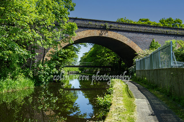

Calle Tron.


Bell Tower of Chiesa dei Santi Apostoli.


Ponte de San Paternian over the Rio di San Luca Canal.


This doorway and mural were in the same entrance hall area, I think they were taken either in the Accademia Bridge or San Marco Square areas of Venice.


Grand Canal Gondola Mooring at Calle della Carita.


Ponte de le Maravegie, the bell tower is the Campo San Trovaso


Cannaregio Canal.


Leonardo da Vinci Museum.


Rio del Palazzo Canal looking towards the Bridge of Sighs, the bridge between is the Ponte de Canonica.


Another of the Rio del Palazzo Canal, taken from the same bridge as above in the opposite direction.


Church of San Zaccaria.


Ponte de la Pieta on the San Marco sea front. The grey building is the Church of the Pieta.


Calle Tron at night.

Clicking any image should open a link in another window to the version on Clickasnap.

Thanks for looking, please take a moment to share and follow me on social media.

All the pictures remain the copyright of Colin Green.

Through a Glass, Darkly: Hebden Bridge Railway Station in Negative

 There's something hauntingly beautiful about old photographs, especially when they're presented in a way that flips our perception....